
|
Boletín de la Sociedad Geológica Mexicana Volumen 74, núm. 3, A180622, 2022 http://dx.doi.org/10.18268/BSGM2022v74n3a180622
|
 |
A LiDAR-based geopedologic approach to address pre-Hispanic agricultural landscapes in Northern Michoacán, West Mexico
Aproximación geopedológica basada en LiDAR para abordar los paisajes agrícolas prehispánicos en el Norte de Michoacán, Oeste de México
Antoine Dorison1,2,*, Christina Siebe Grabach3, Michelle Elliott2,4, Gregory Pereira5
1LabEx DynamiTe, University Paris 1–Panthéon Sorbonne, France.
2 Centre National de la Recherche Scientifique, UMR7041 ArScAn team Environmental Archaeologies, France.
3 Environmental Edaphology Laboratory, Institute of Geology, National Autonomous University of Mexico, CDMX, Mexico.
4 University Paris 1–Panthéon Sorbonne, France.
5 Centre National de la Recherche Scientifique, UMR8096 ArchAm Archaeology of the Americas, France.
* Corresponding author: (A. Dorison) This email address is being protected from spambots. You need JavaScript enabled to view it.
How to cite this article:
Dorison, A., Siebe Grabach, C., Elliott, M., Pereira, G., 2022, A LiDAR-based geopedologic approach to address pre-Hispanic agricultural landscapes in Northern Michoacán, West Mexico: Boletín de la Sociedad Geológica Mexicana, 74 (3), A180622. http://dx.doi.org/10.18268/BSGM2022v74n3a180622
Manuscript received: December 18, 2021;Corrected manuscript received: June 21, 2022; Manuscript accepted: June 23, 2022.
ABSTRACT
The methodical exploitation of arable lands in pre-Hispanic Mesoamerica has been recognized since the 16th century, but the Spanish Conquest caused cultivated landscapes to be dramatically modified. Thus, general amazement remains great when remote sensing techniques (RS) like airborne laser scanning (LiDAR) uncover fossilized farmlands. Recent studies demonstrated that agrarian features are widespread among the remains revealed by LiDAR-derived models. Efforts are being made to map these features but few studies have focused directly on the landforms and soils which they modify. Concurrently, while paleopedology has refined the identification of anthropogenic features within soils, spatial approaches correlating soil covers and archaeological sites have received less attention as perspectives often diverge between archaeological mapping, which often focuses on intra-site elements, and soil mapping, which generally encompasses broader areas. Yet, geoscientists have used RS to predict soil parameters and demonstrated that it could increase accuracy in knowledge-based soil maps. Today, while LiDAR-derived data are facilitating archaeological mapping beyond settlement limits, high-resolution RS also offers opportunities for more accurate soil mapping and calls for harmonization of perspectives. We present a method that combines LiDAR-based RS and fieldwork in archaeology and soil science to address pre-Hispanic cultivated landscapes based on a case study in West Mexico. It focuses on the Zacapu area, where long-lasting archaeological and geoecological research offered a solid background. We used LiDAR visualizations, modeling, and satellite images to detect anthropogenic and geopedologic features. The latter was verified through field surveys and test pits. Archaeological material and soil analyses followed. All data were mapped on GIS. As a result, we were able to update and improve significantly both the archaeological and geopedologic maps. The approach further provided an unprecedented reconstruction of landscape appropriation from the 6th to the 15th century AD. It demonstrates that archaeology, geomorphology, and pedology can efficiently complete each other to address more comprehensively pre-Hispanic cultivated landscapes.
Keywords: ancient agro-ecosystems, Mesoamerica, geoarchaeology, soil mapping, LiDAR.
RESUMEN
La construcción de paisajes antrópicos para el cultivo en la Mesoamérica prehispánica ha sido reconocida desde el siglo XVI. Sin embargo, la conquista española provocó profundos cambios en las estrategias agrícolas, lo que supuso el abandono de muchas de las obras agrícolas prehispánicas. Por ello, el descubrimiento de vastas redes de campos de cultivo antiguos mediante técnicas modernas de teledetección, como los escaneos láser aéreos (LiDAR), siempre es un acontecimiento mediático. Estudios recientes han demostrado que los restos agrarios se encuentran entre los más numerosos revelados por los modelos digitales de terreno LiDAR. Se están realizando esfuerzos para cartografiar estos restos, pero pocos estudios se han centrado aún en las formas del terreno y los suelos que explotaban. Al mismo tiempo, mientras que la paleopedología ha contribuido a perfeccionar la identificación del impacto antropogénico en los suelos, los enfoques espaciales que correlacionan la cubierta del suelo y los patrones de asentamiento arqueológicos han sido menos desarrollados, probablemente porque las perspectivas suelen divergir entre la cartografía arqueológica, que generalmente se centra en las características intra-sitio, y la cartografía edafológica, que abarca áreas más amplias. Al mismo tiempo, los geocientíficos han hecho un amplio uso de la teledetección para predecir las características del suelo y han demostrado que estas tecnologías pueden mejorar la precisión de los mapas tradicionales de suelos. Hoy en día, mientras los datos LiDAR facilitan la cartografía arqueológica más allá de los límites de los asentamientos humanos, la teledetección de alta resolución permite cartografiar los suelos y las formas del terreno con más precisión que nunca. Estos avances tecnológicos invitan a armonizar las escalas de análisis y las perspectivas de investigación. Este trabajo presenta un método que combina la teledetección LiDAR con trabajos de campo arqueológicos y edafológicos para abordar los paisajes cultivados prehispánicos a partir de un estudio de caso en el Occidente de México. Se centra en la región de Zacapu, donde la investigación arqueológica y geoecológica a largo plazo proporciona un contexto sólido. Además, se utilizan visualizaciones LiDAR, modelización e imágenes de satélite para detectar restos antropogénicos y formas del terreno. Estas observaciones se verificaron en campo mediante prospecciones y sondeos. Luego se analizó el material arqueológico y los suelos. Los datos se compilaron en un sistema de información geográfica para poner al día y mejorar los mapas arqueológicos y geopedológicos locales. Con estos resultados se ha permitido reconstruir de forma inédita la apropiación del paisaje del siglo VI al siglo XV d.C. Se ha demostrando que la arqueología, la geomorfología y la edafología se complementan eficazmente para proponer una visión más completa de los paisajes de cultivo prehispánicos.
Palabras clave: agroecosistemas antiguos, Mesoamérica, geoarqueología, cartografía de suelos, LiDAR.
- Introduction: towards a harmonization in archaeological and geoscientific perspectives to address pre-Hispanic cultivated landscapes
The methodical exploitation of arable lands in pre-Hispanic Mesoamerica has been recognized by foreigners since the 16th century. To give only one example, Cortes himself, describing the region of Tlaxcala in Central Mexico, speaks of a “province [that] contains many extensive and beautiful valleys, well tilled and sown, and none are uncultivated” (MacNutt, 1908: 210). The Spanish conquest, however, led to drastic changes in these cultivated landscapes (Rojas, 1988; Whitmore and Turner II, 2001). They are largely due to the rapid generalization of the European mode of production. The introduction of the plow and the beasts of burden facilitated the exploitation of heavier soils and proved to be better adapted to flat areas, whereas, before, pre-Hispanic hand-worked fields readily extended on slopes (Donkin, 1979). Today, ever more powerful remote sensing (RS) techniques, such as airborne laser scanning (LiDAR), are revealing the remains of fossil pre-Hispanic farmlands at unprecedented scales (e.g. Canuto et al. 2018; Chase et al., 2012; Dorison, 2020). RS studies thus corroborate the texts by uncovering material evidence of ubiquitous agrarian features around habitation sites. Efforts are being made to map them. However, few studies (e.g. Chase and Weishampel, 2016; Dorison, 2020; Hightower et al. 2014) have focused on the landforms and soils they modify to address more comprehensively the human-soil relationship.
Concurrently, while paleopedology has made considerable progress in identifying anthropogenic features in soils (Nicosia and Stoops, 2017), the spatialization of information remains relatively limited in and around archaeological sites. In addition to the fact that paleopedological studies are time-demanding and often require high inversion-such as detailed micromorphological analyses-, this may be more broadly related to differences in the scales of investigation and the tools used for mapping in archaeology and soil science. Archaeological mapping generally focuses on built features at a very large scale (in a geographical sense) whereas soil mapping often focuses on broader areas. Thus, soil mapping in archaeology has mostly been confined to the scale of the site (Barba et al. 1995; Middleton, 2004; Wells and Moreno, 2010; Pecci et al. 2017), sometimes extending to its close periphery (Entwisle et al. 1998; Wilson et al. 2009; Abrahams et al. 2010), with the prime objective of studying the human impact on soils rather than the human-soil relationship per se. In contrast, small-scale spatial approaches correlating the respective distributions of soils and archaeological features especially designed to tackle the latter issue (e.g. Sanders et al., 1979; Sanders and Murdy 1982; Coste et al., 1988) have seen little development since the 1970-90s, when these approaches were popular in archaeology. In addition, regarding the tools used, small-scale soil mapping heavily rely on common RS datasets, such as satellite imagery and stereoscopic aerial photography (Girard et al., 2011: 189-214; Zinck, 2012), but these have strong limitations for archaeological mapping. Even today, the resolution of the images often remains insufficient for the detection of surface archaeological elements when the latter are not simply hidden by vegetation. Until recently, these methodological constraints seem to have dissuaded archaeologists from persevering with small-scale spatial approaches correlating geopedologic and archaeological features.
Meanwhile, in approaches commonly known as Digital Soil Mapping (DSM), geoscientists have made good use of advances in RS to predict soil parameters based on the theoretical clorpt model first proposed by Jenny (1941) (and its reformulations) (McBratney et al. 2003; Ma et al. 2019). The power of LiDAR data has been extensively leveraged in DSM, where the topographic factor holds an important place (e.g. Hengl and Reuter, 2009; Aspinal and Sweeney 2012; Beucher et al. 2017). However, the validation of digitally predicted features is one of the main challenges of DSM. Fieldwork is necessary and field data serve as both validation and proxies to improve the models (Lagacherie and McBratney, 2007). Similarly, predicted models can be used to refine more traditional ways to map soils, such as geopedologic approaches (Zinck, 2012). Thus, it has been shown that while DSM approaches cannot replace knowledge-based maps, they can significantly improve their accuracy (Ma et al., 2019).
To sum up, while LiDAR technology is currently becoming a common tool that facilitates archaeological mapping beyond settlement limits, high-resolution RS allows for ever more accurate soil mapping. Technological advances in both fields call for a harmonization of investigation scales and perspectives. This opens new horizons for landscape archaeology and especially for a more comprehensive approach to cultivated ecosystems. This is precisely what we have attempted here through the study of the cultivated landscapes of the Zacapu area (Western Mexico). In this paper, we focus on the methodological contributions of this work to improve the accuracy of archaeological and geopedologic maps, and present the benefits of correlating the two datasets. We begin by briefly introducing the reader to the issues that motivated the development of a study of pre-Hispanic agriculture in the Zacapu area. We continue by detailing the methodology used, which combines archaeology and soil science and allowed us to acquire and process the different datasets. We finally present the main results and discuss the implications of the approach at the methodological level as well as for archaeo-pedological interpretation. For more details on the cultural implications of the study, we invite the reader to refer to previous works and publications focused on these aspects (Dorison, 2019; 2020).
- Issues in the study of pre-Hispanic agriculture in the Zacapu área
2.1. SETTING AND CURRENT LAND USE: THE LAKE BASIN, VOLCANIC HIGHLANDS AND MALPAÍS OF ZACAPU
The Zacapu basin is located between 19° and 20° north latitude, 300 km west of Mexico City, in the Central Mexican Highlands (Figure 1). The climate is temperate subtropical with average temperatures of 12 to 25°C all year round but with a marked day-night thermal range, and below-zero figures commonly occurring in winter (García 2004). Integrated in the North American Monsoon System (Ropelewski et al., 2005), the area receives 800 mm of annual rainfall concentrated between June and October. The environment is strongly influenced by tecto-volcanic activity as Zacapu lies within the Trans-Mexican Volcanic Belt (Ferrari et al. 2012) and the Michoacán-Guanajuato Volcanic Field (Hasenaka and Carmichael, 1985; Demant, 1992), where active forces since the Miocene have induced elevations around 2000 m a.s.l., with peaks above 3000 m a.s.l.
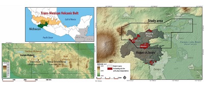 |
| Figure 1. Study area. |
The basin itself corresponds to a graben of about 250 km² closed to the north by an east-west normal fault. It once hosted a pseudo-endorheic lake whose outlet, to the northwest, was made permanent in the early 20th century (Arnauld et al.,1993; Pétrequin, 1994). West of the lacustrine plain are the highlands, which consist of overlapping volcanic structures, mainly lava flows and cones (Demant, 1992; Reyes et al., 2018). The oldest were formed during the Early and Mid-Pleistocene (2 Ma–100 Ka). Weathering and development of medium-age soils on volcanic ash deposits (1 Ma-100 Ka clay-rich soils with common vertic properties) have smoothed the structural morphologies of these geoforms while some display rather advanced erosional and depositional features, such as gullies, carcavas and colluviums (Dorison, 2019). A later phase of volcanic activity in the Late Pleistocene (30 Ka–12 Ka) and Holocene (since 12 Ka) have led to the formation of a cluster of rough-surfaced block lava flows (Demant, 1992; Reyes et al., 2018, 2021). These latter geoforms display marked structural features (e.g. pressure ridges, levées). Volcanic ash soils and colluvic soils are confined to concave areas of these flows (e.g. channels, depressions) (Dorison, 2019). The three youngest block flows, namely El Infiernillo, El Capaxtiro, and El Malpaís Prieto, are dated to 1490–1380 BC, 200–80 BC, and AD 900 respectively (Maghoub et al., 2017; Reyes et al., 2018, 2021) and display almost no soil cover.
Regarding current land use, the whole cluster of Late Pleistocene and Holocene lava flows described above is locally known as the Malpaís of Zacapu (MZC), a “badland” that farmers of European descent considered unsuitable for cultivation. In the old malpaís landforms (Late Pleistocene), where the pedogenesis has allowed the development of an oak forest, wood harvesting and grazing are currently practiced. The most part of the three youngest malpaís landforms are virtually not exploited. In the highlands around the MZC, rainfed (temporal) cultivation is the dominant type of agriculture practiced, in a piecemeal-like system of parcels (Gougeon, 1991). Parts of the highlands are also used for grazing or left under forest. The lacustrine plain, which concentrates the current villages, is entirely covered by parcels of extensive irrigated cultivation (Gougeon, 1991). The permeability of the parent materials of volcanic origin in the highlands and-conversely-the waterlogging of soils in the lacustrine plain make water management a major challenge for agriculture in the Zacapu area (Dorison, 2019).
2.2. ARCHAEOLOGY OF THE ZACAPU AREA AND THE QUESTION OF CULTIVATION IN THE MALPAÍS
The Zacapu lake basin and its surroundings have been thoroughly studied by archaeologists for over 40 years (Darras, 1998; Pereira and Padilla, 2018). Hunter-gatherer occupations have been documented as early as the 6th millennium BC 30 km north of the basin (Faugère, 2006). The earliest evidence of land clearing recorded in lake sediments dates back to 2000 BC (Pétrequin, 1994) and the first sedentary occupations have been identified within the former palustrine zones of the western basin around 100 BC (Arnauld et al., 1993). From the 6th century onwards, the occupation spread to the surrounding slopes and landforms and, despite an important phase of abandonment just before the Spanish conquest, the area remained inhabited without interruption thereafter (Arnauld and Faugère, 1998; Dorison, 2019).
In this long history, the Zacapu region is notably known for four urban settlements dated to the mid-13th century, which could accommodate more than 5,000 inhabitants each (Forest, 2014; Dorison, 2019) and constitute the earliest material evidence of the Tarascan culture (Michelet et al., 2005). At its peak in the 15th century, this political entity dominated Western Mexico (Warren, 1985; Pollard 1993). What is striking in Zacapu is that these four cities were built on top of the three youngest and roughest lava flows of the MZC (Michelet et al., 2005; Michelet, 2008; Forest, 2014; Migeon, 2016; Pereira and Padilla, 2018), whereas, without draft animals or cattle, the Tarascan subsistence economy was based almost exclusively on manual agriculture, supplemented by hunting and gathering. This raises the question of why people have settled in such an environment. The urban centers were abandoned two centuries later, almost a century before the arrival of the Spaniards in Mexico, and the MZC was not occupied thereafter.
The MZC is therefore paradoxical in many ways. Its rugged terrain constitutes at the same time the cradle of a major agrarian society and a time capsule that has preserved archaeological remains in an exceptional way. Yet, regarding agrarian archaeology, it also constitutes a geoecological context seemingly unsuitable for agriculture. Thus, one of the main questions was to understand where the pre-Hispanic inhabitants of the MZC obtained the agricultural products necessary for their subsistence. Before anything else, it is in an attempt to answer this question that we undertook to locate and map the agrarian features in and around the MZC as well as the exploited and exploitable soil landscapes.
- Material and Methods
The study presented in this article is part of a postdoctoral dissertation that focused on the western part of the Zacapu basin. It was undertaken in the frame of the Uacúsecha archaeological project (CEMCA-CNRS). The survey area was an 81 km² window at the interface between the drained lacustrine plain and the highlands, where lie the MZC. The methodology and fieldwork were implemented in the most comprehensive way within an area of 5 km² encompassing the northernmost part of the MZC. It corresponds to the urban site of Malpaís Prieto and its surroundings.
We set up a methodology in three steps. Although the protocol would have required a linear sequence of steps, they were necessarily aligned with the requirements of field operations. For example, several field phases preceded LiDAR data acquisition in 2015 and were thus incorporated into the mapping and corrected afterwards.
3.1. STEP ONE – PRELIMINARY MAPPING
The first step was the compilation of different digitized or georeferenced datasets in a geographic information system (gis) under Qgis to perform a preliminary cartographic interpretation of anthropogenic and geopedological features. We used (1) existing maps (e.g. archaeological maps made by the Uacúsecha project team, topographic, pedological and geological maps provided by the INEGI [DETENAL 1977, 1978, 1979]), (2) satellite images (e.g. Google Earth, Birdseye, ESRI World Imagery), (3) satellite-based digital elevation models (dems) (e.g. ASTER GDEM, SRTM), and (4) 50 cm resolution LiDAR data acquired in 2015 and preprocessed by the National Center for Airborne Laser Mapping (NCALM). Preprocessing of the LiDAR data included classification of the LAS point clouds, semi-automated data correction (including removal of contemporary buildings), and kriging to generate the 50 cm dem.
Satellite images were processed using the DStretch plugin (Harman, 2011) on ImageJ to enhance their readability where necessary. Similarly, LiDAR dems (at 50 cm and resampled to 5 m for some aspects of the geopedological study) were processed on Qgis v.2.8., Sagagis v.2.3. and RVT v.1.3. (SAZU-ZRC) to obtain visualizations improving the readability of features (e.g. shadings, slopes, local relief models, sky view factor) (Kokalj and Hesse, 2017; Dorison, 2019) and to model material movements on the model surface (e.g. water flows and accumulation) (Figure 2). We have notably developed a transparency overlay of three visualizations (Dorison, 2019). In order of position, we superimpose (a) the multiple shadings (MHS) (16 directions, sun elevation angle 35°) which, compared to a simple shading, limits the loss of information in the darkest or the most exposed areas, (b) the Simple Local Relief Model (SLRM), which emphasizes relief according to a given pixel radius (10 or 20 px radius are well-suited for the identification of archaeological features and may be augmented by a second overlaid SLRM visualization at 50 px to highlight landforms in low relief landscapes), and (c) the Sky View Factor (SVF), which materializes the radius of visibility of a pixel with respect to its neighbors (in other words, the darker the pixel, the less visible it is compared to its neighbors and vice versa). SVF thus emphasizes ridges (e.g. elevated walls), and depressions (e.g. excavated paths). We also implemented a colorimetric reclassification of slopes based on geomorphic hillslope models (Dalrymple et al., 1968; Siebe, et al., 2006). This visualization allows us to distinguish “natural” breaks in the slopes at the scale of the archaeological feature (e.g. terrace) as well as at the scale of the landform.
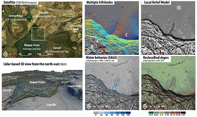 |
| Figure 2. Examples of LiDAR-derived visualizations and modeling A. looted pyramid, B. civic house, C. terrace (stone-ridges) network. |
The preliminary mapping was established on the basis of these datasets by digitizing the geoforms and landforms within them as polygons. The corresponding geopedologic legend was constructed as we went along, systematically naming the features drawn. For each one, one or more potentially associated soil types were proposed according to the geoecological context, whose characteristics could be estimated on the basis of digital data (topography, theoretical humidity) and known information (soil map, geology, previous fieldwork). The legend was constructed following the criteria established by the works of Alfred Zinck (1988, 2012) and Jean Tricart (1965, 1977), among others. In parallel, the archaeological elements were recorded as polylines.
In this case, the legend could rely on the general typology established by the members of the successive archaeological projects in the region (Michoacán projects 1983-1989 [Michelet, 1992], Zacapu III 1993-1997 [Michelet, 1998; Migeon, 1998] and Uacúsecha, 2010-today [Forest, 2014; Dorison, 2019, 2020; Pereira and Padilla, 2018]).
3.2. STEP TWO – FIELDWORK AND ANALYSES
The purpose of the fieldwork was to verify the preliminary mapping. It was carried out during four campaigns of about one month each between 2013 and 2015. At the archaeological level, we carried out several pedestrian surveys, first guided by existing archaeological maps, satellite images and local informants, then by LiDAR images. In addition to seven systematic prospection transects (1,000x100 m) established in forested areas before the acquisition of the LiDAR, the majority of these operations consisted in localized survey, radiating around known archaeological zones.
Thirty test-pits (2x2m) were then carried out specifically for this study, mainly focused on agrarian features (e.g. terraces), for characterization and dating. These excavations were completed by 73 collections of surface material.
At the geopedologic level, beside the systematic description of archaeological test-pits in pedological terms, we conducted more than 100 auger observations and excavated 23 soil pits for sounder descriptions. Fifteen of these pits, concentrated in the direct surroundings of the archaeological site of Mich 31-Malpaís Prieto, were sampled for analysis.
The archaeological material, mostly ceramic sherds (14,000 individuals), was then analyzed at the Centre d’Études Mexicaines et Centre-Américaines (CEMCA) in Mexico City for dating based on local typochronology (Michelet, 2013; Jadot, 2016).
Soil samples (bulk and cylinders for bulk density) were analyzed by the Laboratorio de Edafología Ambiental of the Universidad Nacional Autónoma de México (UNAM) to characterize theoretical soil fertility (total C and N [Perkin Elmer elemental determiner], total P and fixed P [Bray or Olsen methods], pH and conductivity [solution 1:2.5 potentiometer], exchangeable cations [atomic absorption spectrometry], texture [pipette], bulk density [loss on ignition]).
3.3. STEP THREE – DATA INTERPRETATION AND FINAL MAPPING
The field and laboratory data were finally interpreted and integrated to the GIS mapping to perform spatial analyses. At the geopedologic level, we proceeded to the retro-validation of the mapped entities and thus established a 1:50,000 scale map encompassing the whole survey area (Figure 3). A 5 km² test-zone around Mich 31-Malpaís Prieto was mapped at 1:10,000 (Figure 4).
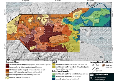 |
| Figure 3. Simplified geopedologic map of the survey area (1:50,000). |
In the same way, the archaeological elements already mapped have been retro-validated and the archaeological map significantly increased (more than 5,000 additional entries) through the interpretation of LiDAR images in light of the field verifications.
Thus, in addition to Michoacan 31-Malpaís Prieto, whose almost exhaustive GPS mapping was available (Forest, 2014), the majority of the other 30 sites in the study window were mapped in their entirety, especially taking into account the agrarian features. As for the other two Tarascan urban centers of the area (Mich. 38 and 95), their exhaustive mapping was conducted in the frame of a collaborative mapping exercise on WebGIS (see Forest et al., 2020).
 |
| Figure 4. Geopedologic map of the northern Malpaís of Zacapu (1:10,000). |
- Results
In this section, we describe the results of the study concerning the characterization of landforms, soils and cultural trajectories in the MZC and its surroundings. Cultural aspects will only be described briefly. We invite the reader to refer to previous publications for more details on this point (Dorison, 2019, 2020).
4.1. GEOPEDOLOGY: AGRONOMIC POTENTIAL OF THE MALPAÍS OF ZACAPU AND ITS SURROUNDINGS
The auger observations, soil pits, and analyses conducted for this study have improved our overall understanding of the local pedology (Figure 3 and 4). Our work affirmed the strong contrast that exists between lowland and upland areas, as well as the variability within the different flows of the MZC. In order to clarify the following paragraphs for non-specialists, we will give an order of magnitude of the productivity of maize-the main Mesoamerican staple crop-for each soil type described.
The lake depression shows soils that are still strongly influenced by the water table despite the drainage in the 20th century. Formed from parent material of lacustrine origin but also from the surrounding intermediate to basic volcanism (ash deposits, colluvium), the soils present for the most part surface horizons rich in bases and organic matter where humification is underway. The profile described on the shore of the former lake (P22 on Figure 3) corresponds to a poorly structured Phaeozem-maybe a Kastanozem (possible secondary carbonates in addition to the shells of lacustrine organisms). This Reference Soil Groups appears to be dominant in the area, in contrast to what is shown on the Detenal map (1979), which suggests a widespread occurrence of Vertisols. The evidence of constant moisture in most of the auger samples indicates that such a development is unlikely. On the other hand, histic horizons were observed several times as well as waterlogged profiles, which is consistent with the occurrence of Histosols proposed by the Detenal.
The mid-Pleistocene volcanic flows that form the islands of the former lake are characterized by soils with high stoniness, often visible on the surface (decimetric blocks), and a high clay content probably resulting from vertisolization processes (Duchaufour, 2001). Gleyic properties were observed in auger samples in the lower part of soil profiles in concave areas. In the absence of described profiles on the islands, the presence of Vertisols and Gleysols is a viable hypothesis. At the same time, the colluvial footslopes have thick silt clay loam A horizons suggesting that they may be Phaeozems in view of the basic parent materials. From an agronomic point of view, the lowland lacustrine soils are therefore chemically fertile and can easily yield over two tons of maize per year (more with chemical fertilizers [Gougeon, 1991]), but their exploitation is strongly constrained by the widespread waterlogging. The risk of crop freezing due to the topographic position is also an important problem. The soils of the former islands are heavy and stony so that current farmers equipped with tractors tend to avoid them. Maize harvests rarely exceed one ton per year in these lands.
In the highlands, a general distinction can be made between soils developed on mid-Pleistocene lava flows and those developed on more recent flows within the MZC. The former, which occur on much older geoforms, display more advanced pedogenetic features than the latter. However, both are soils formed from ash deposits whose profiles have been rejuvenated several times by later tephra deposits and colluvial processes along the slopes. Medium-range soils (1 Ma-100 Ka) on mid-Pleistocene lava flows generally have rather high clay content overall (over 30 percent), which increases with depth (endovertic horizons). The surface horizons show silt loam to silt clay loam textures and are better aerated. Just like the clay content, the structure increases with depth, from granular to blocky. In concave areas where the drainage is slow, true Vertisols may occur. Such soils are also observed on shoulder areas. In these geomorphic contexts, clays tend to accumulate in the sub-soil because of lateral sub-surface water movement while, at the same time, surface horizons tend to be eroded by heavy rainfall during the wet season. Shoulder Vertisols are thus typically shallow and stony. On the other hand, in well-drained areas, the soils have textures and structures better suited for cultivation (silt clay and granular). They also benefit from moisture storage retained by the clays in the deeper horizons. The reference soil groups are Endovertic Phaeozems (P1, 2, 4 and 6), Vertisols (P3), Cambisols (P5) and, presumably, Luvisols (not identified in the soil pits), with overall good chemical fertility thanks to intermediate to basic parent material. These soils can yield over one ton of maize per year, or even more, if carefully managed according to their specific limitations.
Within the MZC, the soil cover is intimately related to the age of the lava flows, the ash deposits that have covered them, and the colluviation processes between their pressure ridges. A distinction can thus be made between the late Pleistocene flows, which present accumulation areas with deep soils between the rocky outcrops, and the Holocene flows, where soils are almost if not completely absent (Hyperskeletic and Nudilithic Leptosols). The former, considered as “old” malpaíses, present Cambisols and Phaeozems with granular texture. They turn powdery when dry. The presence of Andosols is very likely, as indicated on the Detenal map (1979). However, our analyses indicate that phosphate levels are too low for such an identification (Takahashi et al., 2004), although the presence of unaltered volcanic glass cannot be ruled out (unquantified in the present study). The agronomic potential of soils developed on these flows is therefore quite good despite the outcrops and the inherent stoniness of the context, particularly with respect to their chemical fertility (intermediate to basic tephra). Water loss by infiltration is a problem that is slightly compensated by the residual moisture linked to the high porosity of these volcanic ash soils in areas where drainage is not too rapid. Here too, crops could theoretically yield over one ton of maize per year or more. Agronomically, the three Holocene lava flows of the MZC are not completely without interest. Volcanic ash soils have formed on the two oldest-Infiernillo and Capaxtiro-but remain extremely stony (over 40% stoniness) and Technosols were built on all MZC flows by pre-Hispanic populations to occupy them (Puaux, 1989; Forest, 2014). In many cases, test pits revealed soils too thin to cultivate, but some contexts, currently under investigation, may have been associated with agrarian practices (Dorison ,2019).
4.2. ARCHAEOLOGY: SETTLEMENT PATTERN AND ANTHROPOGENIC LANDSCAPE MODIFICATION
Our study has shown that a dichotomy also exists at the archaeological level between the lowlands, where evidence of occupation is scarce-even taking into account the poorer preservation conditions-and the highlands, where the vast majority of remains, especially houses, are concentrated, regardless of the period (Figure 3). Moreover, the rugged lava flows of the MZC constitute the main foci of habitat, despite the probable existence of remains buried in the zones of sediment accumulation between the flows. The highlands are first colonized during the Epiclassic period (AD 600-900). Then, settlements especially concentrate in the late Pleistocene lava flows. By the Early Postclassic (AD 900-1250), the region is largely depopulated, probably due to the eruption of the Malpaís Prieto volcano (Maghoub et al., 2017; Dorison, 2019). In the Middle Posclassic (AD 1250-1450), the region is settled again by non-native populations, probably merging with local groups (Michelet et al., 2005). They build and occupy the urban centers of the MZC on the Holocene flows.
Our work also showed the importance of landscape modification set by pre-Hispanic farmers to exploit their territory from the 6th to the 15th century CE. Agrarian features constitute more than 60% of the detected remains (Figure 5). Without surprise, terraces represent the majority of these features. They prevent erosion and water loss, especially in volcanic ash soils, and create deeper soils, as demonstrated by several excavations. More broadly, management of soil material (i.e. the use of natural soils movements and the relocation of sediments) to rejuvenate surface horizons during the period of use of the terrace is very likely, although not yet clearly demonstrated. Levelling terraces (narrow or wide depending on the spacing) have a stepped profile that creates a flattish area behind a simple wall of stones. Cross-channel terraces are stone walls perpendicular to the slope inside ravines, which retain the flows of soil and water naturally concentrated towards the talweg. Outcrop terraces are distributed along the pressure ridges in Late-Pleistocene volcanic flows. To exploit them, soil have been manually accumulated behind the retaining wall to create a narrow cultivable area, often near the houses that occupy the top of the outcrops. Contour ridges are terrace-like stone ridges that have been excavated on the shoulder of a mid-Pleistocene lava flow. They seem to have been built through a process of removal/accumulation of stones in situ to exploit thin, clayey and stony soils. Finally, other possible agrarian features were detected such as plots walls, area of removal/accumulation of stones in recent volcanic flows to create small plots (number 5 on figure 5) as well as small earth ridges probably associated with water management, but research is still ongoing to prove the agricultural nature of the latter.
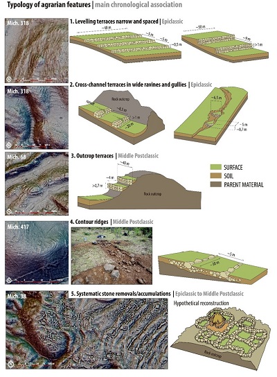 |
| Figure 5. Typology of the agrarian features. |
Chronologically, our study allowed us to demonstrate that there has been a shift in agricultural strategies, or rather, in the scale at which these strategies were implemented between the Epiclassic and the Middle Postclassic. The data from the Early Postclassic are still too uncertain to propose a reliable model for the period. As mentioned, Epiclassic groups settle mainly on late Pleistocene lava flows. Their volcanic ash soils are exploited while residences spread on the outcrops of the geoform to avoid encroaching on arable lands. In the Middle Postclassic, this “non-encroachment” strategy remains broadly similar, but is applied on a different scale: the residential areas are concentrated in the dense urban clusters settled on the roughest lava flows while the surrounding lands are exploited. Another notable difference is the fact that the more clayey soils of the mid-Pleistocene lava flows, which seem not to have been exploited during the Epiclassic, are now cultivated by means of specific agrarian features (i.e. stone ridges). At the same time, some of the volcanic ash soils previously cultivated in late Pleistocene flows are abandoned, perhaps for territorial reasons (Dorison 2019: 608-613). Finally, in the Holocene flows, plots of land are built as early as the Epiclassic period, presumably through the systematic displacement and accumulation of surface rocks. However, the potential for cultivation of the soils thus cleared is still under investigation.
- Discussion
The correlation of archaeological and geopedologic data carried in this study provides a more comprehensive understanding of pre-Hispanic cultivated landscapes. The methodology, and in particular the careful handling of LiDAR data, presents a number of advantages for improving mapping in both disciplines and offers new perspectives for data interpretation.
5.1. GEOPEDOLOGIC MAPPING IMPROVEMENTS
This section focuses on the improvements that can be achieved with the method in terms of soil mapping. The advantages of LiDAR data for archaeological mapping have already been presented in detail in numerous articles and dedicated books (Kokalj and Hesse, 2017, among others, is a good guide of general value; Dorison, 2019: 213-225, 2020 and Forest et al., 2020 presents the main aspects of LiDAR remote sensing in the Zacapu area). Regarding the detection of archaeological features, we only would like to stress out once again that the multiplication and/or combination of image visualizations of the LiDAR dem (e.g. shading, slopes, visibility-related algorithms) is crucial to achieve a somewhat relevant interpretation and to tend towards completeness.
Regarding soils, we mentioned that traditional geopedologic mapping is generally based on photo-interpretation of stereoscopic data developed from aerial photographs. The goal is to interpret what geomorphologists sometimes refer to as morphographic (geometry of geoforms), morphometric (dimensions), morphochronological, and morphogenic criteria (Tricart, 1965; Zinck, 2012). Thus, on stereoscopic images, geoforms are primarily delineated based on the first two criteria. Since these images make it possible to assess the degree of vegetation development, they also provide clues for morphochronological interpretation. The morphogenesis for its part is difficult to assess on photographs alone, besides some specific contexts (e.g. alluvial fans). In this case, other sources of information are needed (e.g. geological map). Additionally, beyond the pedological implications of geomorphology as defined by the clorpt model and its variants (McBratney et al., 2003), aerial images also enable to assess certain soil qualities from visible characteristics in the vegetation (e.g. humidity). Today, these photographs are complemented or even replaced by satellite images, which can be superimposed on digital elevation models (e.g. ASTER GDEM, SRTM). We personally relied heavily on this type of data for the preliminary mapping of our study before the acquisition of LiDAR imagery.
LiDAR data does not replace in any way the primary importance of aerial and satellite photographs but our study illustrates the fact that it enables us to overcome some of their limitations. Indeed, while vegetation is useful in assessing the delineation and nature of geoforms, it is also a significant obstacle to more accurate characterization. Vegetation masks the contours and internal variations of geoforms. Furthermore, variations during the growing cycle, but also current land use and associated political and socio-economic constraints (e.g. different use of the same area for land tenure reasons) influence the delimitation of geoforms and can even lead to interpretation errors. By complementing satellite and aerial photographs with LiDAR remote sensing, it is possible to assess with greater precision the limits of geoforms and their internal characteristics, such as pressure ridges on volcanic flows hidden by the canopy. However, the interest of LiDAR images does not stop there. Their analysis according to an approach akin to DSM studies offers great potentialities. Once again, the combination/superposition of LiDAR visualization is the key.
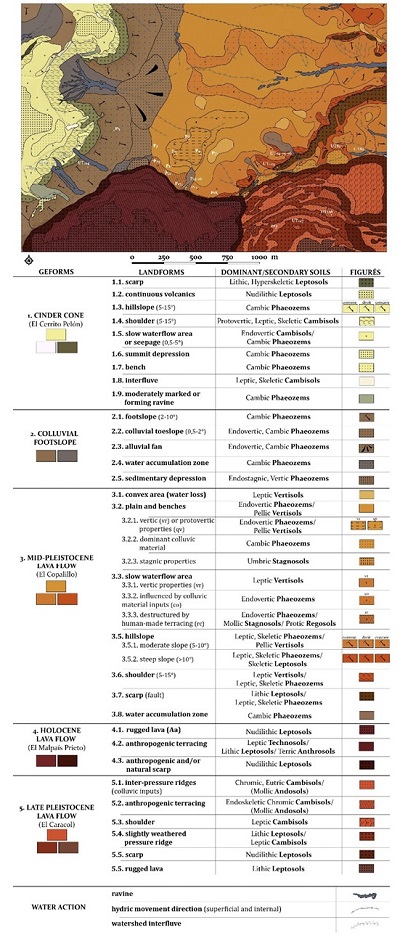
Thus, in a case such as the Zacapu area where the fieldwork has provided insight into the main drivers of the local morpho-pedogenesis (Figure 6), it is possible to correlate in situ observations with topographic data measured on the LiDAR dem to extrapolate the spatial extent of documented geopedologic processes. Among the relevant visualizations, slopes reclassified based on geomorphic models are particularly interesting. They allow the theoretical spatialization of natural breaks within a slope. Simple Local Relief Models (SLRM), generally used to highlight anthropogenic topographic anomalies (e.g. eroded mounds), are also useful for geopedology. Thus, by increasing the algorithm radius - ordinarily set to 10 or 20 pixels to detect anthropogenic features - to 50 pixels or more, it is possible to highlight concavities and convexities at the scale of a geoform. The SLRM thus allows a better appreciation of water and material movements and is particularly useful to address old and smoothed geoforms (e.g. early Pleistocene lava flows).
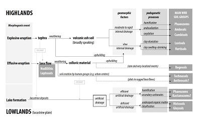 |
| Figure 6. Synthesis of the morpho-pedogenitic processes in the study area. |
Of course, as in the case of traditional spectroscopic mapping, extrapolations remain theoretical and only systematic ground-truthing would precise the spatial limits of soil features. Nevertheless, a partial validation of LiDAR-based interpretations is often possible by confronting the dem with satellite images. Once superimposed, a scrupulous analysis often makes it possible to correlate the morphographic variations detected on the LiDAR dem with variations in vegetation cover. Indeed, topographic micro-variations - highlighted through LiDAR visualizations - essentially influence water movement in soils and, consequently, pedogenetic processes and plant growth. Let us take the example of closed depressions. They are generally shown on satellite images as darker patches of vegetation because of temporary water accumulation in the soil. However, when very shallow and not clearly bounded, they can go undetected when examining satellite images alone. In such cases, the micro-topographic LiDAR visualizations that allows us to delineate more clearly the depressions offer new insights to reinterpret the satellite images. Reciprocally, the detection of darker patches of vegetation on satellite images validate the presence of an area where water tend to accumulate in the soil and thus validate the LiDAR-based interpretation.
We can mention a concrete example in Zacapu where a significant colluvium phenomenon almost invisible on satellite images have been highlighted thanks to LiDAR visualizations (Figure 7). The figure shows the colluvium limits as highlighted by the SLRM and modeling of waterflows. The satellite image shows a corresponding moisture concentration located at the edge of the phenomenon. This boundary have been verified in the field in the auger pits and one of the profile excavated actually show the colluviated horizon, which overlays an old humic Ah horizon.
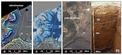 |
| Figure 7. Example of a colluvial event revealed by various clues on LiDAR-derived images, satellite images, and in a soil profile in the field. |
5.2. CONSEQUENCES FOR THE ARCHAEOPEDOLOGICAL INTERPRETATION
In sum, LiDAR data, if intelligently correlated with existing data, allows for greater accuracy in delineating and characterizing geoforms. Our methodology shows that we can improve the accuracy of knowledge-based soil maps and agrees with the results of studies in DSM (Ma et al., 2019). Beyond these rather obvious conclusions, one aspect that we find noteworthy in our approach is that we have taken advantage of advances in LiDAR-based RS primarily designed to detect archaeological features in order to highlight and assess the geomorphology and pedology of our study area. In other words, we have considered geopedologic features as archaeological objects. In doing so, landforms can be fully integrated into the archaeological analysis, notably by addressing the excavations and the mapping of the remains with a pedologist’s eye.
This archaeopedological approach makes it possible to take into account geopedologic criteria to establish the typology of anthropogenic remains and, by extension, to gain precision in the contextualization of elements. Environmental criteria are used as proxies for the archaeological spatial analysis. Agrarian features are considered as ensembles where one of the matching criteria is the exploited ecosystem. In this respect, LiDAR images enable quantitative approaches at an unprecedented scale. At the same time, the spatial proximity of agrarian features - often difficult to date - to better documented remains (e.g. pyramids, ball games, etc.) is also facilitated by LiDAR analysis. This proximity constitutes another diagnostic criterion; a cultural one. Consequently, it is possible to introduce a chronological dimension into the spatial analysis and to associate the remains to particular periods.
Conversely, the soil and landforms, considered as exploited remains, can also be “dated”, not by assigning them an absolute date but a period of preferential use by human beings.
Based on this, archaeology can play a role in the geopedologic mapping too. Our study of pre-Hispanic agriculture at Zacapu brought to light agrarian features whose characteristics correspond to specific geopedologic contexts. Leveling terraces are adapted to soils that are sensitive to erosion and show rapid internal drainage. The stone-ridges mentioned above take advantage of the moisture hold in clay soils and the warmth of the stones on the shoulders of hillslopes. Therefore, the identification of a particular type of agrarian feature can provide a clue to assess the characteristics of the soils they exploit. In other words, the reasoning goes the other way: the idea here is to consider archaeological objects as landforms, with their own geomorphological characteristics and their impact on the pedology at the micro-local scale. Furthermore, ancient farmers tried to improve natural landforms. It is difficult to find out whether these changes were beneficial or detrimental to agricultural productivity over the long term, though the ubiquity and large number of terraces suggest that farmers deemed them useful. What cannot be doubted is that these changes have had a lasting effect on the landforms and continue to have an impact on local soils.
More broadly, this predominantly spatial archaeopedological approach can serve as a guide for establishing paleopedological studies in the true sense of the word (i.e., that study paleosols). Conversely, a paleopedological study always benefits enormously from being contextualized and spatialized. Our approach is perfectly adapted to this type of issue. However, it should be remembered that the case of Zacapu is special, both because of the quality of the LiDAR coverage and the excellent preservation of the remains. Moreover, we focused here on remains dated by ceramics between the 6th and 15th centuries AD. At the same time, we were dealing with relatively young volcanic soils in an environment that has remained relatively unchanged between pre-Hispanic times and the present. All these factors must be taken into consideration and constitute as many limits to our approach.
- Conclusion
LiDAR data have become more and more accessible and widespread in the past few years (Evans, 2020). This constitute undeniably a phenomenal step forward for archaeology. Our study shows it once again. The possibilities for quantitative analysis are dramatically increased, if one takes the time to process the data to exploit fully their potential by combining visualizations. In doing so, we were able to highlight thousands of archaeological remains and, in particular, hard-to-detect agrarian features that allowed the pre-Hispanic farmers of Zacapu to exploit the ecosystem in which they lived. At the same time, these same LiDAR data hold great promise for the future of soil mapping. Beyond their potential to refine proxies in DSM approaches, they can improve more traditional knowledge-based mapping. Our method is certainly more time consuming than DSM approaches but offers the advantage of real-time retro-validation of the data by the cartographer.
More broadly, our study demonstrates that archaeology, geomorphology and pedology - sister disciplines in essence since they are intimately linked to the soil cover and its dynamics - can effectively complement each other. Looking at landforms in the same way as we look at archaeological elements actually broaden the very concept of anthropogenic remain. Scales are apprehended as a continuum. Each built remain is part of a larger context on which it depends, in the same way that artifacts constitute parts of an archaeological context. Our typochronology of agrarian features relies on this idea. Conversely, considering archaeological remains as landforms is a way to see them as fully integrated into the dynamics of the landscapes, in the same way as proposed by the variants of Jenny’s clorpt model that emphasize the anthropic factor “a” (McBratney et al., 2003).
To conclude, the approach presented through the case study of Zacapu revisits the question of human-soil relationship in light of new remote sensing and mapping tools: LiDAR and gis. The multiplication of LiDAR coverage in Mesoamerica promises the reproducibility of the methodology. This archaeopedological approach offers interesting perspectives for a more comprehensive understanding of pre-Hispanic agro-ecosystems, which emancipates itself from textual sources and significantly completes them.
Contributions of authors
Conceptualization: AD; analysis or data acquisition: AD; methodological/technical development: AD, GP, CSB, ME; writing of the original manuscript: AD; writing of the corrected and edited manuscript: AD; graphic design: AD; fieldwork: AD; interpretation: AD, GP, CSB; financing: AD, GP, CSB.
Financing
Antoine Dorison, Gregory Pereira and Christina Siebe Grabach.
References
Abrahams, P. W., Entwistle, J. A., Dodgshon, R. A., 2010, The Ben Lawers historic landscape project: simultaneous multi-element analysis of former settlement and arable soils by X-ray fluorescence spectrometry: Journal of Archaeological Method and Theory, 17(3), 231-248. https://doi.org/10.1007/s10816-010-9086-8
Arnauld, M.-C., Faugère, B., 1998, Evolución de la ocupación en el Centro-norte de Michoacán y la emergencia del Estado Tarasco, in Darras, v., (coord.), Génesis, culturas y espacios en Michoacán: Mexico, CEMCA, 13-34.
Arnauld, M.-C., Carot, P., Fauvet-Berthelot, M.-F., 1993, Arqueología de las Lomas en la cuenca lacustre de Zacapu, Michoacán, México: Mexico, CEMCA, 231p.
Aspinall, J., Sweeney, S., 2012, Digital soil mapping in Ontario, Canada: an example using high resolution LiDAR, in Minasny, B., Malone, B. P., McBratney, A., (eds.), Digital soil assessments and beyond: London, CRS Press, 307-312.
Barba, L., Pierrebourg, F. D., Trejo, C., Ortiz, A., Link, K., 1995, Activités humaines refletées dans les sols d’unités d’habitation contemporaine et prehispanique du Yucatan (Mexique): études chimiques, ethnoarchéologiques et archéologiques: ArchéoSciences, revue d’Archéométrie, 19 (1), 79-95.
Beucher, A., Adhikari, K., Breuning-Madsen, H., Greve, M. B., Österholm, P., Fröjdö, S., Jensen N.H., Greve, M. H., 2017, Mapping potential acid sulfate soils in Denmark using legacy data and LiDAR-based derivatives: Geoderma, 308, 363-372. https://doi.org/10.1016/j.geoderma.2016.06.001
Canuto, M. A., Estrada-Belli, F., Garrison, T. G., Houston, S. D., Acuña, M. J., Kováč, M., Marken, D., Nondédéo, P., Auld-Thomas, L., Castanet, C., Chatelain, D., Chiriboga, C. R., Drápela, T., Lieskovský,T., Tokovinine, A., Velasquez, A., Fernández-Díaz, J. C., Shrestha, R., 2018, Ancient lowland Maya complexity as revealed by airborne laser scanning of northern Guatemala: Science 361, 1355. https://doi.org/10.1126/science.aau0137
Chase, A. S. Z., Weishampel, J., 2016, Using LiDAR and GIS to investigate water and soil management in the agricultural terracing at Caracol, Belize: Advances in Archaeological Practice 4(3), 357–370. https://doi.org/10.7183/2326-3768.4.3.357
Chase, A. F., Chase, D. Z., Fisher, C. T., Leisz, S. J., Weishampel, J. F., 2012, Geospatial revolution and remote sensing LiDAR in Mesoamerican archaeology: Proceedings of the National Academy of Sciences, 109(32), 12916-21. https://doi.org/10.1073/pnas.1205198109
Coste, N., Guilaine, J., Revel, J.-C., 1988, Archéologie et pédologie. Essai de reconnaissance des territoires dʼexploitation autour des sites néolithiques: Bulletin de la Société Préhistorique Française 85, 390-411.
Dalrymple, J. B., Blong, R. J., Conacher, A. J., 1968, A hypothetical nine-unit landsurface rnodel: Zeitschrift für Geomorphologie, N.F. 12 (1), 60-76.
Darras, V.(coord.), 1998, Génesis, culturas y espacios en Michoacán: México, CEMCA, 142p. https://doi.org/10.4000/books.cemca.3387
Demant, A., 1992, Marco Geológico regional de la laguna de Zacapu, Michoacán, México, in Michelet, D. (coord.), El Proyecto Michoacán 1983-1987 : medio ambiente e introducción a los trabajos arqueológicos, Cuadernos de estudios michoacanos 4: México, CEMCA 53–72.
Dirección de Estadística del Territorio Nacional (DETENAL), 1977, Carta Topográfica E14A11 Zacapu, Escala 1:50 000: Mexico City.
Dirección de Estadística del Territorio Nacional (DETENAL), 1978, Carta Geológica E14A11 Zacapu, Escala 1:50 000: Mexico City.
Dirección de Estadística del Territorio Nacional (DETENAL), 1979, Carta Edafológica E14A11 Zacapu, Escala 1:50 000: Mexico City.
Donkin R. A., 1979, Agricultural terracing in the aboriginal new world: Tucson, University of Arizona Press, 196p.
Dorison, A., 2019, Archéologie des systèmes agraires préhispaniques de la région de Zacapu, Michoacán, Mexique. VIIe–XVe siècle apr. J.–C.: Paris, Université Paris 1 Panthéon-Sorbonne, Doctoral Dissertation, 806p.
Dorison, A., 2020, Anthropisation d’un milieu volcanique : approches à partir du LiDAR du Malpaís de Zacapu, Mexique: Archéologies Numériques 4: Université Paris 1 Panthéon-Sorbonne.
Duchaufour, P., 2001, Introduction à la science du sol : sol, végétation, environnement, Science sup: Paris, Dunod, 352p.
Entwistle, J.A., Abrahams, P.W., Dodgshon, R. A., 1998, Multi-element analysis of soils from Scottish historical sites. Interpreting land-use history through the physical and geochemical analysis of soil: Journal of Archaeological Science, 25(1), 53-68.
Evans, D., 2020, Bibliography of Archaeological LiDAR: European Union´s, Cambodian Archaeological LiDAR Initiative. https://angkorLiDAR.org/bibliography/
Faugère B., 2006, Cueva de los Portales : un sitio arcaico del norte de Michoacán, México: Mexico, CEMCA/INAH, 288p. https://doi.org/10.4000/books.cemca.1079
Ferrari, L., Orozco Esquivel, T., Manea, V., Manea, M., 2012, The dynamic history of the Trans-Mexican Volcanic Belt and the Mexico subduction zone: Tectonophysics 522-523, 122–49. https://doi.org/10.1016/j.tecto.2011.09.018
Forest, M., 2014, L’organisation sociospatiale des agglomérations urbaines du Malpaís de Zacapu, Michoacàn, Mexique [1250-1450 après J.-C.]: Paris, Université Paris 1 Panthéon-Sorbonne, Doctoral Dissertation, 597p.
Forest, M., Costa, L., Combey, A., Dorison, A., Pereira, G., 2020, Testing web mapping and active learning to approach LiDAR data: Advances in Archaeological Practice, 8(1), 25-39. https://doi.org/10.1017/aap.2019.42
García, E., 2004, Modificaciones al sistema de clasificación climática de Köppen. Serie Libros 6: México, Instituto de Geografía, UNAM, 97p.
Girard M.-C., Schvartz, C., Jabiol, B., 2011, Étude des sols. Description, cartographie, utilisation: Paris, Science sup, Dunod, 432p.
Gougeon, O., 1991, El noroeste de Michoacán : un paisaje en busca de identidad, in Reyes, C., Gougeon, O. (eds.), Paisajes rurales en el Norte de Michoacán, Cuaderno de estudios michoacanos 3: México, CEMCA, 53-101.
Harman, J., 2011, Using DStretch to investigate paintings in Cueva San Borjitas, Baja California Sur, Mexico, in 76th Annual Meetings of the Society for American Archaeology: Sacramento, California, SAA.
Hasenaka, T., Carmichael, I.S.E. 1985, The cinder cones of Michoacán – Guanajuato, Central Mexico : Their age, volume and distribution, and magma discharge: Journal of Volcanology and Geothermal Resources, 25(1-2), 105-124. https://doi.org/10.1016/0377-0273(85)90007-1
Hengl, T., Reuter, H.I. (eds.), 2009, Geomorphometry : concepts, software, applications: Developments in Soil Science 33, Elsevier, 722p.
Hightower, J. N., Butterfield, A. C., Weishampel, J.F., 2014, Quantifying ancient Maya land use legacy effects on contemporary rainforest canopy structure: Remote Sensing 6 (11), 10716. https://doi.org/10.3390/rs61110716
Jadot, E., 2016, Productions céramiques et mobilités dans la région tarasque de Zacapu (Michoacán, Mexique): continuités et ruptures techniques entre 850 et 1450 apr. J.-C.: Paris, Université Paris 1 Panthéon-Sorbonne, Doctoral Dissertation, 675p.
Jenny, H., 1941, Factors of soil formation. A system of quantitative pedology: New York, Dover Publications Inc, 320p.
Kokalj, Ž., Hesse, R., 2017, Airborne laser scanning raster data visualization: a guide to good practice. vol. 14: Ljubljana, Založba ZRC, Institute of Anthropological and Spatial Studies, 90p. https://doi.org/10.3986/9789612549848
Lagacherie, P., McBratney, A. B., 2007, Spatial soil information systems and spatial soil inference systems: Perspectives for digital soil mapping, in Lagacherie, P., McBratney, A. B., Voltz, M., (eds.), Digital soil mapping: An introductory perspective: Amsterdam, Elsevier, 3–24.
Ma, Y., Minasny, B., Malone, B. P., Mcbratney, A. B., 2019, Pedology and digital soil mapping (DSM): European Journal of Soil Science, 70 (2), 216-235. https://doi.org/10.1111/ejss.12790
MacNutt, F. A., 1908, Letters of Cortes: London, G.P. Putnam, 384p.
Mahgoub, A. N., Reyes-Guzmán, N., Böhnel, H. Siebe, C., Pereira, G., Dorison, A., 2017, Paleomagnetic constraints on the ages of the Holocene Malpaís de Zacapu lava flow eruptions, Michoacán (México): Implications for archeology and volcanic hazards: Holocene 28 (2), 229–245. https://doi.org/10.1177/0959683617721323
McBratney, A. B., Mendonça Santos, M.L., Minasny, B., 2003, On digital soil mapping: Geoderma, 117, 3–52. https://doi.org/10.1016/S0016-7061(03)00223-4
Michelet, D. (ed.), 1992, El Proyecto Michoacán 1983-1987 : medio ambiente e introducción a los trabajos arqueológicos. Cuadernos de estudios michoacanos 4: Mexico, CEMCA, 197p.
Michelet, D., 1998, Topografía y prospección sistemática de los grandes asentamiento del malpaís de Zacapu: claves para un acercamiento a las realidades sociopolíticas, in Darras, V. (coord.), Génesis, culturas y espacios en Michoacán: México, CEMCA, 51-68.
Michelet, D., 2008, Vivir diferentemente. Los sitios de la fase Milpillas (1250–1450 dC) en el malpaís de Zacapu (Michoacán), in Sanders, W.T., Mastache, A.G., Cobean, R.H., (eds.), El Urbanismo en Mesoamérica / Urbansim in Mesoamerica, vol. 1: INAH-The Pennsylvania State University, México-University Park, 447-499.
Michelet, D., 2013, Cerámicas del Centro-Norte de Michoacán entre el Clásico y el Posclásico, in Pomédio, C., Pereira, G., Fernández Villanueva, E. (eds.), Tradiciones cerámicas del Epiclásico en el Bajío y regiones aledañas: cronología e interacción: Oxford, BAR International Series, Archaeopress, 48–56.
Michelet, D., Pereira, G., Migeon, G., 2005, La llegada de los Uacúsechas a la región de Zacapu, Michoacán: Datos arqueológicos y discusión, in Manzanilla, L. (ed.), Reacomodos demográficos del clásico al posclásico en el centro de México: Mexico, Instituto de Investigaciones Antropológicas, UNAM, 137–153.
Middleton, W.D., 2004, Identifying chemical activity residues on prehistoric house floors: a methodology and rationale for multi-elemental characterization of a mild acid extract of anthropogenic sediments: Archaeometry, 46 (1), 47-65. https://doi.org/10.1111/j.1475-4754.2004.00143.x
Migeon, G., 1998, El poblamiento del malpaís de Zacapu y de sus alrededores, del clásico al posclásico, in V. Darras (coord.), Génesis, culturas yespacios en Michoacán: México, CEMCA, 35–45.
Migeon, G., 2016, Patrones de asentamiento del Malpaís de Zacapu (Michoacán, México) y de sus alrededores en el Posclsáico: Oxford, Archaeopress Publishing, 152p.
Nicosia, C., Stoops, G., 2017, Archaeological soil and sediment micromorphology: New York, John Wiley and Sons, 476p. https://doi.org/10.1002/9781118941065
Pecci, A., Barba, L., Ortiz, A., 2017, Chemical residues as anthropic activity markers. Ethnoarchaeology, experimental archaeology and archaeology of food production and consumption: Environmental Archaeology 22(4), 343-353. https://doi.org/10.1080/14614103.2017.1359354
Pereira, G., Padilla Gutiérrez, E. F., 2018, La cuidad perdida. Raíces de los soberanos tarascos: Mexico, INAH/CEMCA, 121p.
Pétrequin, P., 1994, 8000 años de la Cuenca de Zacapu : evolución de los paisajes y primeros desmontes: Mexico, CEMCA, 144p. https://doi.org/10.4000/books.cemca.2340
Pollard, H. P., 1993, Tariacuri’s legacy: The pre-Hispanic state: Norman, University of Oklahoma Press, 340p.
Puaux, O., 1989, Les pratiques funéraires tarasques (approche ethnohistorique et archéologique): Paris, Université Paris 1 Panthéon-Sorbonne, Ph.D. dissertation.
Reyes-Guzmán, N., Siebe, C., Chevrel, M. O., Guilbaud, M.-N., Salinas, S., Layer, P., 2018, Geology and radiometric dating of Quaternary monogenetic volcanism in the western Zacapu lacustrine basin (Michoacán, México): implications for archeology and future hazard evaluations: Bulletin of Volcanology, 80(2), 18. https://doi.org/10.1007/s00445-018-1193-5
Reyes-Guzmán, N., Siebe, C., Chevrel, M. O., Pereira, G., 2021, Late Holocene Malpaís de Zacapu (Michoacán, Mexico) andesitic lava flows: rheology and eruption properties based on LiDAR image: Bulletin of Volcanology, 83(4), 28. https://doi.org/10.1007/s00445-021-01449-0
Rojas-Rabiela, T., 1988, Las siembras de ayer. La agricultura indigena del siglo XVI: Mexico, Secretaría de Educación Pública, CIESAS, 230p.
Ropelewski, C. F., Gutzler, D. S., Higgins, R. W., Mechoso, C. R., 2005, The North American Monsoon System, in Chang, C. P., Wang, B., Lau, N.C.G., (eds.), The global monsoon system: research and forecast, in International Committee of the Third International Workshop on Monsoons (IWM-III): Hangzhou, China: Genève, Secretariat of the World Meteorological Organization, 207-218.
Sanders, W. T., Murdy, C. N., 1982, Cultural evolution and ecological succession in the valley of Guatemala: 1500 BC—AD 1524, in Flannery, K.V., (ed.), Maya subsistence: Studies in memory of Dennis E. Puleston: New York, Academic Press, 19-63.
Sanders, W. T., Parsons, J. R., Santley, R. S., 1979, The basin of Mexico. Ecological processes in the evolution of a civilization: New York, Academic Press, 561p.
Siebe, C., Jahn, R., Stahr, K., 2006, Manual para la descripción y evaluación ecológica de suelos en el campo: México, Sociedad Mexicana de la Ciencia del Suelo, 57p.
Takahashi, T., Nanzyo, M., Shoji, S., 2004, Proposed revisions to the diagnostic critera for andic and vitric horizons and qualifiers of ardosols in the world reference base for soil resources: Soil Science and Plant Nutrition, 50(3), 431-7. https://doi.org/10.1080/00380768.2004.10408497
Tricart, J., 1965, Principes et méthodes de la géomorphologie: Soil Science 100 (4), 300. https://doi.org/10.1097/00010694-196510000-00015
Tricart, J., 1977, Précis de géomorphologie 2: Géomorphologie dynamique générale: Paris, Société dʼÉdition dʼEnseignement Supérieur, 345p.
Warren, B., 1985, The conquest of Michoacán. The Spanish domination of the Tarascan kingdom in Western Mexico, 1521-1530: Norman, University of Oklahoma Press, 352p.
Wells, E., Moreno Cortés, J., 2010, Chimie du sol et activités humaines anciennes: les exemples archéologiques du Mexique et d’Amérique Centrale: Étude et Gestion des Sols, 17 (1), 67–78.
Whitmore, T. M., Turner, B. L., 2001, Cultivated Landscapes of Middle America on the Eve of Conquest: Oxford, Oxford University Press, 338p.
Wilson, C.A., Davidson, D. A., Cresser, M. S., 2009, An evaluation of the site specificity of soil elemental signatures for identifying and interpreting former functional areas: Journal of Archaeological Science 36(10), 2327-2334. https://doi.org/10.1016/j.jas.2009.06.022
Zinck, J. A., 1988, Physiography and soils. Lecture notes: Enschede, International Institute for Aerospace Survey and Earth Sciences (ITC), 156p.
Zinck J. A., 2012, Geopedologia. Elementos de geomorfología para estudios de suelos y de riesgos naturales: Enschede, Faculty of Geo-Information Science and Earth Observation, 131p.
Peer Review under the responsability of Universidad Nacional Autónoma de México.
This is an open access article under the CC BY-NC-SA license(https://creativecommons.org/licenses/by-nc-sa/4.0/)