
|
Boletín de la Sociedad Geológica Mexicana Volumen 72, núm. 2, A220819, 2020 |
 |
Soils in extreme conditions: the case of the catenas karst-marsh-coastline in the Mexican Caribbean
Suelos en condiciones extremas: el caso de las catenas karst-pantano-costa en el Caribe mexicano
Patricia Fragoso-Servón1, Alberto Pereira Corona1,*, Francisco Bautista Zúñiga2, Benito Prezas Hernández1, Nina A. Reyes1
1 División de Ciencias e Ingeniería. Universidad de Quintana Roo. Boulevard Bahía esq. Ignacio Comonfort s/n. Colonia del Bosque. 77019, Chetumal, Quintana Roo, Mexico.
2 Centro de Investigación en Geografía Ambiental. Universidad Nacional Autónoma de México. Antiguo camino a Pátzcuaro no. 8701. Colonia Ex Hacienda de San José de la Huerta. 58190, Morelia, Michoacán, Mexico.
* Corresponding author: (A. Pereira) This email address is being protected from spambots. You need JavaScript enabled to view it.
How to cite this article:
Fragoso-Servón, P., Pereira Corona, A., Bautista Zúñiga, F., Prezas Hernández, B., Reyes, N. A., 2020, Soils in extreme conditions: the case of the catenas karst-marsh-coastline in the Mexican Caribbean: Boletín de la Sociedad Geológica Mexicana, 72 (2), A040619. http://dx.doi.org/10.18268/BSGM2020v72n2a040619
Abstract
This work is a contribution to the knowledge of marshy and coastal karstic environments, which show great spatial variability of landforms, soil, and plant formations. The aim of this study is to describe the interactions between different combinations of relief, soil, water availability, and vegetation in the Caribbean coast of Yucatan Peninsula using four toposequences to generate basic information for rational use and more effective conservation of resources in that area. The relief is plain with a slight slope and undulations that tend to form flooded areas during the rainy season. To characterize transects, stratified sampling was used in 38 points. Landforms that dominate the area are karst depressions, sandy beach, sandy dune ridges, and geological steps. The vegetation types are coastal dune vegetation, coastal scrub, three types of mangrove (red, white, and buttonwood), semiperennial and subdeciduous low forest, disturbed low forest, and natural and induced palm forests. According to the World Reference Base for Soil Resources, soils identified were Leptosol, Phaeozem, Solonchak, Gleysol, Arenosol, and Histosol. Soil groups have a wide variety of primary and secondary qualifiers due to extreme conditions that change often. The sequence of soil along the catenas is related to the distance to the beach and landforms. Thus, their presence and sequencing in each of them is not the same. Near the waterfront are the Arenosols; Leptosols lie in the far west. The distribution of the remaining soil groups between these two points varies with depressions, temporary or seasonal flooding areas, proximity to the sea, and depth of the water table. Diversity of these soil groups show the great heterogeneity of the karstic relief. Results of this study are worth using to prepare the management plan of the natural protected area and to be applied in nearby zones with similar characteristics.
Keywords: Karst, toposequence, soil, Quintana Roo, coastal environment.
Resumen
Este trabajo contribuye al conocimiento de los ambientes kársticos palustres y costeros, los cuales muestran gran variabilidad espacial de geoformas, suelos y formaciones vegetales. El objetivo fue analizar las interacciones entre diferentes combinaciones de relieve, suelo, disponibilidad de agua y vegetación en la costa Caribeña de la Península de Yucatán, utilizando cuatro toposecuencias, para generar información básica para el uso racional y más efectiva conservación de los recursos del área. El relieve es una planicie con ligera pendiente y ondulaciones que forman zonas de inundación durante la temporada de lluvias. Para caracterizar los transectos, se utilizó un muestreo estratificado con 38 puntos. Las geoformas predominantes son depresiones kársticas, playas arenosas, crestas arenosas y escalones geológicos. La vegetación presente es: vegetación de duna costera, matorral costero, tres tipos de mangle (rojo, blanco y botoncillo), selva baja subperennifolia y subcaducifolia, selva baja perturbada y palmar natural e inducido. De acuerdo con la Base Referencial Mundial del Recurso Suelo, se identificaron Leptosols, Phaeozems, Solonchaks, Gleysols, Arenosols e Histosols. Los grupos de suelos tienen variedad de calificadores primarios y secundarios como consecuencia de las condiciones extremas y cambiantes. La secuencia de suelos en las catenas está relacionada con la distancia a la playa y las formas del relieve. Por ello, su presencia y secuenciación en cada una de ellas no es la misma. Cerca de la costa hay Arenosols, en el extremo oeste hay Leptosols. La distribución de los tipos de suelo restantes entre estos dos puntos varía con: presencia de depresiones, áreas de inundación temporal o estacional, proximidad al mar y profundidad del nivel freático. La diversidad de suelos muestra la heterogeneidad espacial del ambiente costero kárstico. Los resultados del estudio son valiosos para elaborar el programa de manejo del área natural protegida y para aplicarse en áreas cercanas con características similares.
Palabras clave: Karst, toposecuencia, suelo, Quintana Roo, ambiente costero.
- Introduction
In the east side of the Yucatan Peninsula, Mexico, there is a wide diversity of soils resulting from the interaction of karstic, marsh, coastline areas and relief. They are very important environmental conditions for the formation of soils because these are of recent formation and they are changing due to both the sea waves and the continental freshwater flows that model them. Particularly, karstic areas are environments of high variability. Geomorphological factors along with the great diversity of soils, climatic variations, availability of water, and biota have allowed the development of many characteristic environments (Ford and Williams, 2007; Day, 2010; De Waele, 2017).
Use of the geopedological approach in tropical karstic low energy landforms has led to identification of several distinctive environments in the Yucatan Peninsula: depositional, erosional, structural, dilutional, residual, and mixed (Bautista et al., 2015; Aguilar et al., 2016; Fragoso-Servón et al., 2016). The basis of soil research is geomorphology (Zinck, 1989, 2012; Cotler, 2003; Bocco et al., 2009), and the composition and plant structure of soils result from water-soil-plant relations (Kirkham, 2014). Therefore, the study of complex environments must follow an interdisciplinary approach, oriented to the description of landscape composition and structure, through a stratified sampling method using clearly identifiable and comparable toposequences. Interdisciplinary approaches provide a way for more complete and integral analysis of environmental and biotic elements of a region in semi-detailed studies. They also provide reliable information to describe the structure, processes, and interactions that determine the dynamics and status of natural systems (Martínez-Zavala et al., 2005; Schaetzl and Anderson, 2005; Zavala et al., 2014).
Recently, toposequences and transects have been used to define soil sequences (catenas), ecological gradients, and, in general, to understand the relationships between geomorphology, soil, water availability, and plant cover in a spatial context. If georeferenced, this information shows soil variation, topography, vegetation, and local resource management patterns (Gobin et al., 2000; FAO, 2007). Information derived from these studies is useful for conservation strategy designs and degraded natural systems restoration (López-Galindo et al., 2003), needed due to the impact of phenomena (i.e., hurricanes, floods, fire, or human action) that can cause irreversible damage (Zinck, 2005).
In the western portion of the Caribbean Sea, along the coastal area of the Yucatan Peninsula, detrital and biogenic cumulative coastal environments and erosive coastal processes meet where the limestone reaches the sea. This forms beaches and rocky shores providing optimal zones for tourism development (Buzinde and Manuel-Navarrete, 2013). The area is a Natural Protected Area (NPA) that features fragile, protected vegetation types and species (Prezas, 2011). It lies in a region exposed to degradation pressures caused by tourism development in the Mayan Riviera (Brown, 2013). Such degradation takes the form of illegal harvesting of fauna (Urquiza-Haas et al., 2009) and vegetation (Urquiza-Haas et al., 2007), and pollution of soil and aquifer.
The description of spatial and temporal changes of landscape components in relation to human activities allows us to understand and foresee their dynamics. Such a description also provides a framework for the study of ecological succession and ecosystem dynamics. It is the basis for policy design and strategy planning towards the conservation and management of zones to appropriately harness and conserve natural resources (Ojima et al., 1994; Mena et al., 2016).
The aim of this study is to describe the interactions between different combinations of relief, soil, water availability, and vegetation in the Caribbean coast of the Yucatan Peninsula using toposequences to generate basic information for rational use and more effective conservation of resources in that area. Our goal is to support a more rational use and conservation of resources and to enrich the NPA management plan.
- Materials and methods
2.1 STUDY AREA
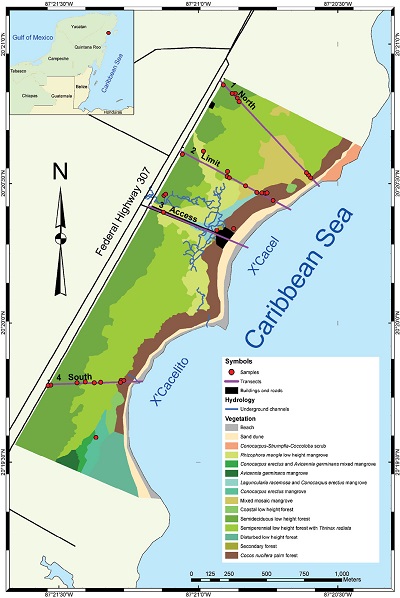
This research was conducted on the eastern coast of Quintana Roo, Mexico between 20°20ʹ39.31″ and 20°19ʹ31.49″ north, and between 87°21ʹ1.13″ and 87°21ʹ40.53″ west. The coast forms two inlets known as X’Cacel and X’Cacelito. The entire area comprises 146.3 ha (Figure 1) in which three zones are distinguished: the karst zone, the flooding zone, and the coast. Climate is Aw2 (x’) i’w” warm subhumid with summer rains, the wettest of subhumid climates. Annual rainfall is 1358.3 mm; 10.3% of it is winter rainfall. There is low thermal oscillation and midsummer drought (CONAGUA, 2015; INEGI 2015).
|
|
|
Figure 1. Study area and transects. |
The area lies on limestones from the upper Tertiary. Limestones are recrystallized, white to cream, with microfauna and scattered, well-cemented cockles and bivalves (Lopez-Ramos, 1973, 1975).The relief is a subhorizontal plain ranging from 0 m to 7 m (Fragoso-Servón et al., 2014), with a slight elevation and undulations that form permanent or seasonal flooding zones.
Rainwater easily infiltrates across the subsoil, forming underground streams that feed at least four cenotes. These are part of the hydrologic system Xuna’an-Ha, which flows from northwest to southeast and emerge at a rocky point between the two inlets of X’Cacel and X’Cacelito (QRSS, 2018). This beach hosts the largest number of nesting sea turtles Caretta caretta and Chelonia mydas in the region (Prezas, 2011). The remaining area serves as a refuge for wildlife, and as a recreational space for nearby communities and tourists.
There are nine types of vegetation: coastal sand dunes, coastal scrub, mangroves, semiperennial low forest (SPLF), subdeciduous low forest (SCLF), coastal low forest, disturbed low forest, palm forests (natural and induced), and secondary forests (Periódico Oficial del Gobierno del Estado de Quintana Roo, 2000). The chit palm (Thrinax radiata), kuka palm (Pseudophoenix sargentii), and ponytail palm (Beaucarnea pliabilis), classified as endangered species, are common in the NPA. Red mangrove (Rhizophora mangle), black mangrove (Avicennia germinans), white mangle (Laguncularia racemosa), and buttonwood (Conocarpus erectus), which amount to one fifth of plant cover, are species subject to special protection according to the Official Mexican Norm 059 (SEMARNAT, 2010).
2.2 METHODOLOGY
All information was processed in a geographic information system. For topographic reconstruction, a 15 m resolution digital elevation model (DEM) was used as basic input (INEGI, 2016). The DEM was enhanced and adjusted with field measurements and checks prior to extraction of landforms using the method depicted by Fragoso-Servón et al. (2017). Once identified, landforms were field verified.
Four transects were drawn between federal highway 307 and the coastline (Figure 1): two in the north, one in the central area, and one in the south. Federal highway 307 to the west and the beach to the east are used as limits of the study area to have a space free of infrastructure disturbances.
Thirty-eight sampling points were established along the four transects: nine in the northern transect, eleven in the limit zone, seven in the access transection, and ten in the southern transect. The main vegetation type and soil group was recorded at each sampling point.
At each sampling site pedological ditches were dug for profile description (FAO, 2007) and horizon soil sampling. Given the coincidence between techniques described by the Mexican Official Standards (NOM) and those recommended by the International Union for Soil Science (IUSS), both NOM identifier and technic name are provided between parentheses.
Soil properties measured were color (AS-22, Munsell charts); texture (AS-09, Bouyoucos method); structure; percentage of gravel size and bigger fragments; bulk density (Gravimetric method); pH (AS-02, 1:2 water-soil ratio); electrical conductivity (AS-18, Conductivity meter method); organic matter percentage (AS-07, Walkley-Black method); cation exchange capacity (AS- 12, Ammonium acetate extraction method); and Ca, Mg, Na, and K exchangeable bases (AS-12, atomic absorption spectrophotometry method). All soil properties were tested according to methods in the Official Mexican Norm 021 (SEMARNAT, 2000).
Soils were classified according to the rules in World Reference Base for Soil Resources (IUSS Working Group WRB, 2015).
Four environmental factors were recorded for each transect: landform integrity (presence of fractures or cracks), surface water availability (presence of ponding due to aquifer exposure or open exposures like dissolution blowholes, fractures or collapses), type of soil (data used for soil type identification are shown in Table 1), and main plant formation (vegetation, composition, and abundance).
|
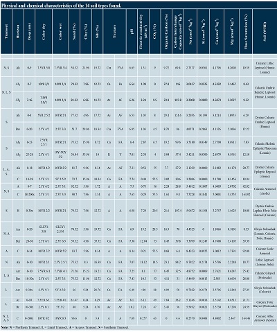
Table 1. Physical and chemical characteristics of the 14 soil types found. |
|
|
- Results
Each transect extends from the Federal Highway 307 to the tide line on the beach. Visible forms of terrain and their attributes were identified along the transect to define toposequences. The four toposequences have different lengths due to heading and distance between the Federal Highway and the beach, which varies with coastline changes.
3.1 TRANSECT 1 (NORTH)
Transect 1 has a length of 800 m, and the height varies between 0 m and 5 m (above mean sea level). Six types of topography, five types of vegetation, and six different soils (Figure 2) were identified. This transect starts at 5 m high in a karst platform that descends along 96 m to a height of 3 m. The dominant soil is Calcaric Lithic Leptosol (Humic, Loamic), very shallow, with abundant roots and organic material. After that 96 m, the staggered karst platform extends 453 m with a Calcaric Umbric Rendzic Leptosol (Humic, Loamic), deeper than the preceding soil with abundant organic matter content. SPLF vegetation dominates in these first 549 m, with chit palm (Thrinax radiata), chechén (Metopium brownei), jabin (Piscidia piscipula), chaca (Bursera simaruba), and chicozapote (Manilkara zapota) as the most representative species.
|
|
|
Figure 2. Transect 1: Sample point; SPLF: Semiperennial Low Forest; mamsl: meters above mean sea level; Distance in meters; Depth in cm; Soil horizons: O: organic, A: mineral surface soil, B: mineral subsoil, C: parent material, R: bedrock; Subordinate characteristics: h: accumulation of organic matter; z: salts accumulation; r: strong reductive environment. Note: Color and or hatching in drawings is solely for drawing purposes it is related to none of the soil characteristics. |
Beyond the platform, a depression with a fractured basement (floodable low) is formed, allowing vegetation to access the underlying aquifer. This depression spans 157 m (from 549 m to–706 m along transect) covered by red, white, and buttonwood mixed mangrove (Rhizophora mangle, Laguncularia racemosa, and Conocarpus erectus) over a hydromorphic saline soil of the Gleyic Solonchak (Loamic, Calcaric, Folic, Humic) that extends to the marginal rocky slope area. In this 62 m zone, lines of coconut palms (Cocos nucifera) grow on thin and lightly salty soils, i.e., a Umbric Lithic Leptosol (Loamic, Salic). These are relicts of coconut oil production plantations from the 1960s. Beyond the floodable low, lies the wind-carried sand zone comprising a 23 m wide sandy dune with Dystric Calcaric Arenosol (Aeolic) and coastal scrub vegetation, ending in a 19 m white, sandy beach slope (791-810) of a Calcaric Albic Arenosol (Aeolic) that extends to the tide line.
3.2 TRANSECT 2 (LIMIT)
Transect 2 was made with twelve sampling points (Figure 3), 270 m south of Transect 1. It has a length of 752 m, with five types of topography, six changes in vegetation, and alternating thin, hydromorphic, saline, and sandy soils.
This transect starts at the geological ridge with 6 m (one meter more than the preceding transect) with a slight rocky slope (two meters differential height) that extends for 75 m with typical species of SCLF such as kouka palm (Pseudophoenix sargentii) and ponytail palm (Beaucarnea pliabilis). These species are classified as threatened by the Official Mexican Standard 059 (SEMARNAT, 2010). There is also akits (Thevetia gaumeri) and pigeon plum (Coccoloba diversifolia) on a Calcaric Umbric Skeletic Leptosol (Humic) soil, which is shallow, very rocky, and rich in organic matter.
|
|
|
Figure 3. Transect 2: Sample point; SCLF: Subdeciduous Low Forest; SPLF: Semiperennial Low Forest; mamsl: meters above mean sea level; Distance in meters; Depth in cm; Soil horizons: O: organic, A: mineral surface soil, B: mineral subsoil, C: parent material, R: bedrock; Subordinate characteristics: h: accumulation of organic matter; z: salts accumulation; r: strong reductive environment. Note: Color and or hatching in drawings is solely for drawing purposes it is related to none of the soil characteristics. |
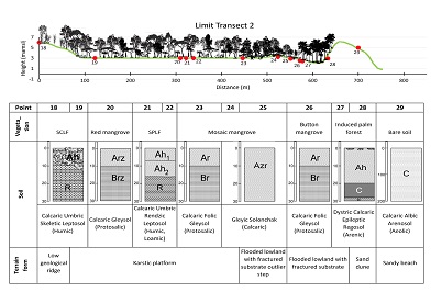
The karst platform extends 460 m beyond the geological ridge, with evidence of dissolution voids. SPLF vegetation alternates with chit palm and with seasonally and permanently flooded areas where red, white and buttonwood mangroves grow. The salt content of the soil increases eastward going from a Calcaric Gleysol (Protosalic) to a Gleyic Solonchak (Calcaric) to the non-saline flooded lowland with fractured basement.
The floodable lowland has a 99 m from one border to the other along the transect. Here, the sand content in the soil increases, going from buttonwood mangrove vegetation over Gleysols towards Arenosols with coconut plantations and then to the sandy dune with dominance of beach bean (Canavalia rosea), riñonina (Ipomoea pes-caprae), and cocklebur (Cenchrus incertus). The terrain rises from (2 m high to – 6 m high) to finally drop forming a white sandy beach up to the tide line.
3.3 TRANSECT 3 (ACCESS)
Transect 3 is 648 m long (Figure 4) and runs mainly through mangrove areas. It is parallel to the public access to the beach and reaches the middle of X’Cacel beach. In the seventh sampling point, five topographic forms and five vegetation types were identified on Leptosols, Solonchaks, Gleysols, and Arenosols.
|
|
|
Figure 4. Transect 3: Sample point; SCLF: Subdeciduous Low Forest; SPLF: Semiperennial Low Forest; mamsl: meters above mean sea level; Distance in meters; Depth in cm; Soil horizons: O: organic, A: mineral surface soil, B: mineral subsoil, C: parent material, R: bedrock; Subordinate characteristics: h: accumulation of organic matter; z: salts accumulation; r: strong reductive environment. Note: Color and or hatching in drawings is solely for drawing purposes it is related to none of the soil characteristics. |
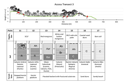
Like the previous two transects, transect 3 starts at the geological ridge at 5 m height followed by a flat platform 76 m length where the presence of SCLF vegetation over a stony substrate and thin soils (Calcaric Umbric Skeletic Leptosol (Humic)) was observed. Beyond this, there is a karstic platform extends for 106 m where a decrease in percentage of gravel size and bigger fragments and soil depth (less than 10 cm) Calcaric Lithic Leptosol (Humic, Loamic).At 106 m from the NW end of the transect, flooded lowlands with fractured basement begin and extend to 436 m, with a predominance of mangrove vegetation. Initially, red mangrove grows on saline soils with permanent flooding classified as Gleyic Solonchak (Loamic, Calcaric, Folic, Humic). Subsequently, as salinity decreases and hydromorphy remains constant on a Calcaric Gleysol (Protosalic), white and buttonwood mangrove develops toward areas where sand from the dune accumulates.
As the sand increases, the vegetation changes to SPLF with plenty of chit palm over a Dystric Calcaric Epileptic Regosol (Arenic) to finally reach the coastal dunes of less than 2 m high. This end of the transect 3 is a 58 m wide formation of sandy beach, the widest beach area that X’Cacel has during the time of year when the sampling was done.
3.4 TRANSECT 4 (SOUTH)
In the southern part of the study area (Figure 5) the geological ridge and the coastal dune are higher (7 m). Along the transect, the geological ridge extends from 0 to 23 m and the staggered karst platform from 23 to 214 m. The karstic platform is shorter (131 m).Vegetation composition changes from SCLF to SPLF and patches of induced coconut palm plantations. Soils are thin (Leptosols) along 368 m. They differ in depth (from 0 cm to 10 cm depth), rock content (around 40%), and the amount of deposited or incorporated organic matter. Thin and rocky soils are in the geological ridge; those with higher organic matter content are in the platform.The karstic platform, lying in the middle part of the transect, has soils deeper (up to 25 cm) and rich in organic matter, classified as Calcaric Skeletic Epileptic Phaeozem (Loamic) Epileptic, with a predominance of SPLF.
|
|
|
Figure 5. Transect 4: Sample point; SCLF: Subdeciduous Low Forest; SPLF: Semiperennial Low Forest; mamsl: meters above mean sea level; Distance in meters; Depth in cm; Soil horizons: O: organic, A: mineral surface soil, B: mineral subsoil, C: parent material, R: bedrock; Subordinate characteristics: h: accumulation of organic matter; w: change of color or silt proportion; Note: Color and or hatching in drawings is solely for drawing purposes it is related to none of the soil characteristics. |
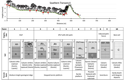
Beyond the platform, towards the beach, a 93 m wide lowland with fractured basement shows groundwater exposure by subsidence and dissolution processes. Depressions and similar forms accumulate sand and organic matter, favoring the development of natural palm vegetation on a Dystric Calcaric Epileptic Regosol (Arenic).At 461 m lies the section of sand dune with coconut palms where the height increases to more than 6 m. This plain gradually changes to a 48-meter sandy beach with rocky biogenic deposits in X’Cacelito. To the south of this transect lies an area with permanent flooding, covered with black mangrove (Avicennia germinans) growing on Dystric Ombric Leptic Fibric Folic Histosol (Calcaric).In the study area, Leptosols are dominant in the (very pebbly) geological ridge and karst-staggered platform where SCLF and SPLF vegetation grow. In the flooded lowlands and areas with fractures and cracks, where groundwater is exposed, soils are hydromorphic. There are Gleysols and Solonchaks, where mangrove (red, black, white, and buttonwood) has ideal conditions to develop.
Shoreward, sand content increases by wind deposition. Arenosols dominate and natural and induced palm vegetation prevails. Finally, this sequence reaches the coastal sandy dunes zone in which the presence of coastal dune scrub signals the proximity of the beach Arenosols dominated by the white sandy beaches that are typical of the Mexican Caribbean.
- Discussion
The karstic coast of Quintana Roo is classified as an eogenetic karst. In such systems, cavernous features include secondary porosity in epikarst as much as other eogenetic features, many of them attributed to glacioeustatic changes (Kambesis and Coke, 2013). The most densely dissolved karst of the coast of Quintana Roo occurs between Muyil and Puerto Morelos (south and north from X’Cacel-X’Cacelito study area respectively) and affects vegetation coverage and soil formation in the studied catenas.
The recognition of soils, vegetation, landforms, and water availability along the studied catenas may allow the evaluation of the environmental functions or ecosystem services of these components. Several sets of extreme soil development conditions, all of them imposing very distinctive environmental constraints in these catenas, resulted in different soil types. One of the soil types, and probably the most common in the study area, is a very thin soil layer over the calcareous rocky parental material. These are different kinds of Leptosols that fill tiny depressions of no more than a few millimeters depth. In these cases, water is the most important limiting factor due to low water retention and very rapid infiltration (Isphording, 1976).
In the study area, relative aridity and water scarcity define an extreme condition for soil formation. In these conditions, soils rapidly develop a mineralizing process, may be similar to that described by Sedov et al. (2008). This process just a few millimeters below soil surface, allowing tiny herbaceous plants to grow. Most of these little soil pockets (often hidden below litter) show a patchy distribution in zones with parental rocks moderately fractured. The smaller and bigger cavities (from a few centimeters up to 2 or 3 m in diameter) are used in other parts of the Yucatan Peninsula for growing plants in home gardens because of the natural accumulation of soil and the relatively impermeable surface of the rock (compared to that of soil) (Fedick et al., 2008).
Unlike data presented by Gray et al. (2016), these catenas do not have Calcisols because weathering of parental material runs at a very different rate from that for pedogenesis. The abundance of organic matter and repeated changes in water supply allow for rapid bedrock decomposition and soil formation far beyond the rate of dissolution or breaking of rocks, favoring the formation of Leptosols in thin layers over the bare superficially dissolved rock. These Leptosols are very fragile in such conditions, as shown by some paths (made by both animals and people) that run into the forest and lack this thin and finely patched pattern of soil accumulation, developing instead Nudilithic Leptosols that are characterized by organic matter (mainly litter) accumulation over more or less fractured rocks.
A contrasting extreme condition can be found a short distance away in places where the fractures in rocks reach the shallow aquifer in the area (Kambesis and Coke, 2013). In those places, parts of the rock rest over underground flows and dissolution has formed caverns, which in turn have collapsed forming flooded depressions with fractured basements that allow tree roots to penetrate down to the water table below the surface (Querejeta et al., 2007; Estrada-Medina et al., 2013). Some of these depressions have a dense cover of black mangrove with just a few specimens of other species (Mckee, 1993). Histosols are the main type of soil in such depressions, and can be found coexisting with the other two combinations of soil and vegetation over small distances of no more than 50 m.
Several of these combinations amount to a high hydrogeologic variability that promotes soil and vegetation diversity, as has been described by Bautista et al. (2011). Alternatively, Sedov et al. (2007) attributed this patched distribution in small scales to differentiated decarbonatation rates of the parental materials. This study shows that, among the soils of the karst area, Leptosols support the tropical forests high primary productivity and high rates of decomposition of organic matter, as pointed out by Sedov et al. (2007) and Cabadas-Báez et al. (2010). High productivity and decomposition of organic matter indicate increased rock weathering, and uneven distribution of soils as a consequence of permanent redeposition of soils in geomorphologically unstable karstic environments.
Gleysols and Histosols, in turn, support the hydrophilic vegetation as noted by Beach (1998) for northwestern Yucatan Peninsula. Both soils differ in that for Gleysols water only gets into contact with soil at times when the water table rises with tides or intense rains, while Histosols is in permanent contact through the fractured limestone that is filled with plant debris and fine materials dragged from the surface during rains. Both are conditions adequate for organic carbon accumulation.
Arenosols support coastal scrub and sandy dune vegetation. These are sites of low primary productivity and low organic carbon accumulation. However, beyond the first string of dunes toward inland, some relicts of coconut plantations still strive in those poor soils as the low forests in the cases studied by Beach (1998).
Notice that, due to the tight relationships between at least three of the four studied factors, the high biological richness clearly depends upon combinations of landform, soils, and water availability (Mckee, 1993; Beach, 1998; Fedick et al., 2008; Bautista et al., 2011; Pedro, 2017; Beach et al., 2018). Functionally, both dunes (Arenosols) and wetlands (Gleysols and Histosols) act as protective barriers against extreme hydrometeorological events, such as hurricanes, for the tropical forests in the karstic inner zone (Leptosols) (Granek and Ruttenberg, 2007; Ostling et al., 2009; Feagin et al., 2010; Spalding et al., 2014).According to Zinck (2005), the ecosystems and communities identified in the study area are particularly fragile and vulnerable because of their tropical nature and ecotonal coastal structure, where diversity is high, but the system redundancy and resistance to small disturbances are low. Regarding the same ecosystems, Sedov et al. (2008) referred to a factor contributing to fragility, thinness, and heavy weathering of soils that a very intensive pedogenesis gets influenced by vertical transport of material to karst sinkholes and fractures.
Because of the complexity of the coastal system studied, the characterization of the study area must be the first attempt to understand the relationship between relief, soil, water, and plants and should provide the framework for the restoration, conservation, and sustainable management of the NPA (Ojima et al., 1994; Lopez-Galindo et al., 2003; Mena et al., 2016). In this case, toposequence analysis provides a combination of outstanding and characteristic environmental attributes of the area and helps to identify interactions between physical and biotic components (Eyre, 1979; Applegarth and Dahms, 2001; Phillips, 2001; Lopez-Galindo et al., 2003).
Catenas make possible to observe spatial heterogeneity and complex relationships between geological, geomorphological, hydrological, and ecological attributes (Engel et al., 1996; Sommer and Schlichting, 1997). For the marine coastal environment in the northern portion of the Yucatan Peninsula, Bautista et al. (2004) and Leirana and Bautista (2014) reported that soils present in beach ridges are Solonchaks and Arenosols; the former filling the lower microrelief and Arenosols in the upper parts. They also reported the presence of Histosols, Solonchaks, and Leptosols for coastal lagoons and flooded karstic plains, which coincides with the findings presented here but at different scale.
Considering all the depicted characteristics and surrounding dynamics, the main degradation threats identified for these systems are as follows. Tourists modify the microrelief, soil and vegetation cover of sand dunes and beach, which favor Eolic erosion and sand transport toward inland (Davenport and Davenport, 2006; Schlacher et al., 2011). In the same way, anthropogenic disturbances along tracks and paths inside forests and mangrove stands will prevent soil accumulation in the tiny depressions and favoring soil transport toward fractures and sinkholes, thus preventing plant growing on the rock surface and modifying the rock weathering rates.
Also, the sea level rise, which makes soils saltier and changes vegetation dramatically (Granek and Ruttenberg, 2007; McKee et al., 2007; Spalding et al., 2014). In this scenario brackish water in caves and karstic funnels near the coast will change rock dissolution rates. Sea level rise forces upward the underground brackish water through fractures and dolines changing mangroves distribution and soil characteristics land inward.
- Conclusions
The freshwater flows, the marine swell, and the recent karst condition generate a great variety of landforms that in turn produce an important variability in the soils. Both extreme and changing conditions generate a great variability of primary and secondary qualifiers in the soils of the studied catenas.
Eight different landforms were identified in the karstic coastline of Quintana Roo in the study area: sandy beach, sandy beach with biogenic deposits, sandy dune, rocky depression, flooded lowlands with fractured basement, karstic platform, staggered platform, and the karstic geological ridge. Such heterogeneity means that communities extend over small areas, hence their fragility, causing subcommunities of this size to easily change in composition or even disappear if soil, climate, or other factors change.
Six reference soil groups were identified: Leptosol, Phaeozem, Solonchak, Gleysol, Histosol, and Arenosol. Soil groups have a wide variety of primary and secondary qualifiers due to heterogeneity in terrain forms and water availability. Seven types of vegetation were found: semiperennial low forest, semideciduous low forest, mangroves (red, white, buttonwood, and black), natural palm forest, induced palm plantation, coastal scrublands, and coastal dune vegetation.
Across the toposequences a succession of newly formed soils alternating with older ones is evident. On the coast there are soils that accumulate material by wind dragging and sea erosion, with little or no profile differentiation but with a dense vegetation cover that favors soil formation. An example is Arenosols, located beyond the sandy dune toward inland and protected from the wind with palm vegetation and coconut plantations.
As limestone dissolves and fractures, subsidence processes form lowlands and depressions that accumulate materials and allow ponding and flooding processes by precipitation and upwelling from the nearby shallow aquifer. Such conditions favor the formation of soils like Gleysols, or Solonchaks where salt accumulates.
Going up the karstic platform, SPLF vegetation grows with limited rooting due to shallow or highly rocky Leptosols. Finally, the SCLF dominant vegetation lies at the top, where moisture content in the geological ridge is the lowest.
The characterization of the site, from geological, edaphic, water availability, and associated vegetation points of view, establishes the foundation for the development of conservation strategies. These should ensure the continuity of ecological processes that are part of nutrient and water cycling and the formation and evolution of soil and vegetation.
Anthropogenic disturbances in such fragile ecosystems can easily lead to deforested areas. Erosion in the environments previously depicted will result in large areas of denuded rock, as seen previously in other areas of the coast like Xel-Ha, Tulum, and others.
Acknowledgements
We thank Laboratory of Ecology and Land Use Planning of the University of Quintana Roo for the facilities given for the use of cartographic information, field trips, and the use of computer equipment for statistical analysis through the projects “FOMIX-UQRoo.2011-2”, and “Update of the Socioecological Conditions of the Natural Protected Area X’Cacel - X’Cacelito and its Immediate Area of Influence” UQRoo- CA-38 for its support in the field work.
References
Aguilar, Y., Bautista, F., Mendoza, M.E., Frausto, O., Ihl, T., 2016, Density of karst depressions in Yucatán state, Mexico: Journal of Cave and Karst Studies, 78(2), 51–60. https://doi.org/10.4311/2015ES0124
Applegarth, M.T., Dahms, D.E., 2001, Soil catenae of calcareous tills, Whiskey Basin, Wyoming, USA: Catena, 42(1), 17-38. https://doi.org/10.1016/S0341-8162(00)00116-8
Bautista, F., Estrada, H., Jiménez, M., González, J., 2004, Relación entre el relieve y unidades de suelo en zonas cársticas de Yucatán: Terra Latinoamericana, 22(3), 243-254. http://www.redalyc.org/articulo.oa?id=57322301
Bautista, F., Palacio-Aponte, G., Quintana, P., Zinck, J.A., 2011, Spatial distribution and development of soils in tropical karst areas from the Peninsula of Yucatan, Mexico: Geomorphology, 135, 308–321. https://doi.org/10/fjx5md
Bautista, F., Frausto, O., Ihl, T., Aguilar, Y., 2015, Actualización del mapa de suelos del estado de Yucatán México: un enfoque geomorfopedológico y WRB: Ecosistemas y Recursos Agropecuarios, 2(6), 303-315.
Beach, T., 1998, Soil constraints on Northwest Yucatan, Mexico: pedoarchaeology and Maya subsistence at Chunchucmil: Geoarchaeology An International Journal, 13, 759–791. https://doi.org/10/c48mh6
Beach, T., Ulmer, A., Cook, D., Brennan, M.L., Luzzadder-Beach, S., Doyle, C., Eshleman, S., Krause, S., Cortes-Rincon, M., Terry, R., 2018, Geoarchaeology and tropical forest soil catenas of northwestern Belize: Quaternary International, 463, 198–217. https://doi.org/10.1016/j.quaint.2017.02.031
Bocco, G., Mendoza, M., Priego, Á., Burgos, A., 2009, La cartografía de los sistemas naturales como base geográfica para la planeación territorial: México, D.F., Secretaría de Medio Ambiente y Recursos Naturales, Instituto Nacional de Ecología, Universidad Nacional Autónoma de México, Centro de Investigaciones en Geografía Ambiental, 72 p. http://cambioclimatico.gob.mx:8080/xmlui/handle/publicaciones/203
Brown, D.F., 2013, Tourists as colonizers in Quintana Roo, Mexico: The Canadian Geographer / Le Géographe canadien, 57, 186–205. https://doi.org/10.1111/cag.12008.
Buzinde, C.N., Manuel-Navarrete, D., 2013, The social production of space in tourism enclaves: mayan children’s perceptions of tourism boundaries: Annals of Tourism Research, 43, 482–505. https://doi.org/10.1016/j.annals.2013.06.003.
Cabadas-Báez, H., Solleiro-Rebolledo, E., Sedov, S., Pi-Puig, T., Gama-Castro, J., 2010, Pedosediments of karstic sinkholes in the eolianites of NE Yucatán: A record of Late Quaternary soil development, geomorphic processes and landscape stability: Geomorphology, 122, 323–337. https://doi.org/10/fshksv
Comisión Nacional del Agua (CONAGUA), 2015, Información climatológica (en línea): Ciudad de México, Servicio Meteorológico Nacional, disponible en <http://smn.cna.gob.mx>, consultado mayo 11 de 2018.
Cotler, H., 2003, El uso de la información edáfica en los estudios ambientales: Gaceta Ecológica, 33–42. https://www.redalyc.org/articulo.oa?id=539/53906804
Davenport, J., Davenport, J.L., 2006, The impact of tourism and personal leisure transport on coastal environments: a review: Estuarine, Coastal and Shelf Science, 67, 280–292. https://doi.org/10/d7gwwf
Day, M., 2010, Human interaction with Caribbean karst landscapes: past, present, future: Acta Carsológica, 39(1), 137-146.
De Waele, J., 2017, Karst processes and landform, in Richardson, D., Castree, N., Goodchild, M.F., Kobayashi, A., Liu, W., Marston, R. (eds.), The International Encyclopedia of Geography: New York, John Wiley and Sons, 14 p. https://doi.org/10.1002/9781118786352.wbieg0968.
Engel, S., Gardner, T., Ciolkosz, E., 1996, Quaternary soil chronosequences on terraces of the Susquehanna River, Pennsylvania: Geomorphology, 17(4), 273-294. https://doi.org/10.1016/0169-555X(96)00005-0
Estrada-Medina, H., Graham, R.C., Allen, M.F., Jiménez-Osornio, J.J., Robles-Casolco, S., 2013, The importance of limestone bedrock and dissolution karst features on tree root distribution in northern Yucatán, México: Plant Soil, 362, 37–50. https://doi.org/10/f4h66g
Eyre, S.R., 1979, Vegetation and Soils: A World Picture: Great Britain, Edward Arnold Publishers Ltd., 328 p.
Feagin, R.A., Mukherjee, N., Shanker, K., Baird, A.H., Cinner, J., Kerr, A.M., Koedam, N., Sridhar, A., Arthur, R., Jayatissa, L.P., 2010, Shelter from the storm? Use and misuse of coastal vegetation bioshields for managing natural disasters: Conservation Letters, 3, 1–11. https://doi.org/10/d98r9w
Fedick, S.L., De Lourdes Flores Delgadillo, M., Sedov, S., Rebolledo, E.S., Mayorga, S.P., 2008, Adaptation of Maya Homegardens by “Container Gardening” In Limestone Bedrock Cavities. Journal of Ethnobiology, 28, 290–304. https://doi.org/10.2993/0278-0771-28.2.290
Food and Agricultural Organization of the United Nations (FAO), 2007, Technical papers no. 6 Land Evaluation towards a revised framework: Rome, Italy, FAO, 107 p. http://www.fao.org/3/a-a1080e.pdf
Ford, C., Williams, P., 2007, Karst hydrogeology and geomorphology: Chichester, England, John Wiley and Sons, 576 p.
Fragoso-Servón, P., Bautista, F., Frausto, O., Pereira, A., 2014, Caracterización de las depresiones kársticas (forma, tamaño y densidad) a escala 1:50000 y sus tipos de inundación en el Estado de Quintana Roo, México: Revista Mexicana de Ciencias Geológicas, 31(1), 127-137. http://www.scielo.org.mx/pdf/rmcg/v31n1/v31n1a10.pdf
Fragoso-Servón, P., Bautista, F., Pereira, C.A., Frausto, M.O., 2016, Distribución de Suelos en ambientes tectokársticos en la porción este de la Península de Yucatán, México: GEOS, 36, 265–273. https://ugm.org.mx/publicaciones/geos/pdf/geos16-2/distribucion-36-2.pdf
Fragoso-Servón, P., Pereira, A., Bautista, F., Zapata, G., 2017, Digital soil map of Quintana Roo, Mexico: Journal of Maps, 13, 449–456. https://doi.org/10.1080/17445647.2017.1328317
Gobin, A., Campling, P., Deckers, J., Feyen, J., 2000, Integrated toposequence analysis to combine local and scientific knowledge systems: Geoderma, 97(1-2), 103-123. https://doi.org/10.1016/S0016-7061(00)00029-X
Granek, E.F., Ruttenberg, B.I., 2007, Protective capacity of mangroves during tropical storms: a case study from ‘Wilma’and ‘Gamma’in Belize: Marine Ecology Progress Series, 343, 101–105. https://doi.org/10/fbzfgz
Gray, J.M., Bishop, T.F.A., Wilford, J.R., 2016, Lithology and soil relationships for soil modelling and mapping, Catena, 147, 429–440. https://doi.org/10/f8773h
Instituto Nacional de Estadística Geografía e Informática (INEGI), 2015, Mapa de climas de Quintana Roo, Escala 1:1,000,000 (shapefile). Sistema de descarga de productos digitales, disponible en http://www.beta.inegi.org.mx/temas/mapas/climatologia/consultado 4 mayo 2015.
Instituto Nacional de Estadística Geografía e Informática (INEGI), 2016, Mapa topográfico de Quintana Roo, Escala 1:50,000 (shapefile). Sistema de descarga de productos digitales, disponible en <http://www.beta.inegi.org.mx/temas/mapas/topografico/> consultado 4 mayo 2015.
Isphording, W.C., 1976, Weathering of Yucatan Limestones: The Genesis of Terra Rosas: Carbonate Rocks Hydrogeol. Yucatan Penins. Mex. 259–274. http://archives.datapages.com/data/nogs/data/006/006029/0259.htm
IUSS Working Group WRB, 2015, Base referencial mundial del recurso suelo 2014, Actualización 2015. Sistema internacional de clasificación de suelos para la nomenclatura de suelos y la creación de leyendas de mapas de suelos. Informes sobre recursos mundiales de suelos 106: Rome, FAO, 205 p. http://www.fao.org/3/i3794es/I3794es.pdf
Kambesis, P.N., Coke, J.G., 2013, Overview of the Controls on Eogenetic Cave and Karst Development in Quintana Roo, Mexico, in Lace, M.J., Mylroie, J.E. (eds.), Coastal Karst Landforms: Springer Netherlands, Dordrecht, 347–373. https://doi.org/10.1007/978-94-007-5016-6_16
Kirkham, M.B., 2014, Principles of soil and plant water relations: Manhattan, USA, second edition, Academic Press, 598 p. https://doi.org/10.1016/C2013-0-12871-1
Leirana, J.L., Bautista, F., 2014, Patrones de asociación entre la cobertura vegetal y la calidad del suelo en el matorral costero de la reserva Río Lagartos, Yucatán: Ciencia UAT, 8(2), 44-53. http://www.redalyc.org/articulo.oa?id=441942931005
López-Galindo, F., Muñoz, D., Hernández, M., Soler, A., Castillo, M., Hernández, I., 2003, Análisis integral de la toposecuencia y su influencia en la distribución de la vegetación y la degradación del suelo en la Subcuenca de Zapotitlán Salinas, Puebla: Boletín de la Sociedad Geológica Mexicana, 1(1), 19-41. http://dx.doi.org/10.22201/igl.14053322p.BSGM560103
López-Ramos, E., 1973, Estudio Geológico de la Península de Yucatán: Boletín de la Asociación Mexicana de Geólogos Petroleros, 25, 23-76.
López-Ramos, E., 1975, Geological Summary of the Yucatan Peninsula, in Nairn, A.E.M., Stehli, F.G. (eds.), The Gulf of Mexico and the Caribbean: Springer, US, 257–282. https://doi.org/10.1007/978-1-4684-8535-6_7
McKee, K.L., 1993, Determinants of mangrove species distribution in neotropical forests: biotic and abiotic factors affecting seedling survival and growth: Louisiana State University and Agricultural & Mechanical College, PhD dissertation. https://digitalcommons.lsu.edu/gradschool_disstheses/5656
McKee, K.L., Cahoon, D.R., Feller, I.C., 2007, Caribbean mangroves adjust to rising sea level through biotic controls on change in soil elevation: Global Ecology and Biogeography, 16, 545–556. https://doi.org/10/chs96x
Martínez-Zavala, A. Jordán, A., Anaya, M., Gómez, I., Bellinfante, N., 2005, Clasificación automática de elementos geomorfológicos en la cuenca del río Tepalcatepec (México) a partir de un modelo digital de elevaciones: Cuaternario y Geomorfología, 19(3-4), 49-61.
Mena, J.L., Rubio, H., Deza, J., Yagui, H., Vergel, C., Kanashiro, L., Valdivia, R., 2016, Servicios ecosistémicos que brindan las Áreas Naturales Protegidas. Documento de trabajo No. 23: Perú, Cano, 59 p. http://www.sernanp.gob.pe/documents/10181/116191/23+Doc+Traba
jo++Servicios+Ecosist%C3%A9micos+que+
brindan+las+ANP.pdf/a919597c.eef7-4673-
a9a8-30dff8b83160
Ojima, D.S., Galvin, K.A., Turner, B.L., 1994, The Global Impact of Land-Use Change: Bioscience, 44(5), 300-304. https://doi.org/10.2307/1312379.
Ostling, J.L., Butler, D.R., Dixon, R.W., 2009, The biogeomorphology of mangroves and their role in natural hazards mitigation: Geographical Compass, 3, 1607–1624. https://doi.org/10/cs5wbp
Pedro, N., 2017, Modelación de densidad aparente y retención de carbono: Arenas carbonatadas en playas cubanas. M+A Revista Electrónica Medioambiente 18(1), 49-61. https://doi.org/10/gfxcvp
Periódico Oficial del Gobierno del Estado de Quintana Roo, 2000, Decreto por el que se establece el Programa de manejo de la Zona Sujeta a Conservación Ecológica “Santuario de la tortuga marina X’Cacel-X’Cacelito”, ubicada en el municipio de Solidaridad, estado de Quintana Roo: México, Periódico Oficial del Estado de Quintana Roo, abril 28 de 2000, 87 p.
Phillips, J., 2001, Divergent evolution and spatial structure of soil landscape variability: Catena, 43(2), 101-113. https://doi.org/10.1016/S0341-8162(00)00122-3
Prezas, B., 2011, Áreas naturales protegidas en Quintana Roo, in Pozo, C., Armijo, N., Calmé, S. (eds.), Riqueza Biológica de Quintana Roo: Un análisis para su conservación, 1: México, Comisión Nacional para el Conocimiento y Uso de la Biodiversidad (CONABIO), Colegio de la Frontera Sur (ECOSUR), Gobierno del Estado de Quintana Roo, Programa de Pequeñas Donaciones-México, 300–309. https://www.biodiversidad.gob.mx/region/EEB/pdf/QuintanaRoo/TOMO_1/1_Capitulo_baja.pdf
Querejeta, J.I., Estrada-Medina, H., Allen, M.F., Jiménez-Osornio, J.J., 2007, Water source partitioning among trees growing on shallow karst soils in a seasonally dry tropical climate: Oecologia, 152, 26–36. https://doi.org/10/fsfqhd
Quintana Roo Speleological Survey (QRSS), 2018, Survey and cartography of the underwater caves of Quintana Roo Mexico: Tulum, Mexico (en línea), QRSS, disponible en < http://www.caves.org/project/qrss/qrssesp.htm>, consultado 4 mayo 2018.
Schaetzl, R., Anderson, S., 2005, Soils Genesis and Geomorphology: New York, USA, Cambridge University Press, 817 p.
Schlacher, T.A., De Jager, R., Nielsen, T., 2011. Vegetation and ghost crabs in coastal dunes as indicators of putative stressors from tourism. Ecological Indicators, 11, 284–294. https://doi.org/10/bk3fzz
Secretaria de Medio Ambiente y Recursos Naturales (SEMARNAT), 2000, Norma Oficial Mexicana que establece las especificaciones de fertilidad, salinidad y clasificación de suelos. Estudios, muestreos y análisis (NOM-021-RECNAT-2000): México D.F., Diario Oficial de la Federación, 31 de diciembre de 2002, 116 p. http://www.ordenjuridico.gob.mx/Documentos/Federal/wo69255.pdf
Secretaria de Medio Ambiente y Recursos Naturales (SEMARNAT), 2010, Norma Oficial Mexicana para Protección ambiental - Especies nativas de México de flora y fauna silvestres - Categorías de riesgo y especificaciones para su inclusión, exclusión o cambio - Lista de especies en riesgo, (NOM-059-ECOL-2001): México D.F., Diario Oficial de la Federación (Segunda sección), 30 de diciembre de 2010, 78 p.
Sedov, S., Solleiro-Rebolledo, E., Fedick, S.L., Gama-Castro, J., Palacios-Mayorga, S., Vallejo Gómez, E., 2007, Soil genesis in relation to landscape evolution and ancient sustainable land use in the northeastern Yucatan Peninsula, Mexico: Atti della Società Toscana di Scienze Naturali Serie A 112, 115–126.
Sedov, S., Solleiro-Rebolledo, E., Fedick, S.L., Pi-Puig, T., Vallejo-Gómez, E., Flores-Delgadillo, M. de L., 2008, Micromorphology of a Soil Catena in Yucatán: Pedogenesis and Geomorphological Processes in a Tropical Karst Landscape, in Kapur, S., Mermut, A., Stoops, G. (eds.), New Trends in Soil Micromorphology: Berlin, Heidelberg, Springer Berlin Heidelberg, 19–37. https://doi.org/10.1007/978-3-540-79134-8_3
Sommer, M., Schlichting, E., 1997, Archetypes of catenae in respect to matter-a concept for structuring and grouping catenae: Geoderma, 76(1-2), 1-33. https://doi.org/10.1016/S0016-7061(96)00095-X
Spalding, M.D., Ruffo, S., Lacambra, C., Meliane, I., Hale, L.Z., Shepard, C.C., Beck, M.W., 2014, The role of ecosystems in coastal protection: Adapting to climate change and coastal hazards: Ocean & Coastal Management, 90, 50–57. https://doi.org/10/gfsqmn
Urquiza-Haas, T., Dolman, P.M., Peres, C.A., 2007, Regional scale variation in forest structure and biomass in the Yucatan Peninsula, Mexico: Effects of forest disturbance: Forest Ecology and Management, 247, 80–90. https://doi.org/10.1016/j.foreco.2007.04.015
Urquiza-Haas, T., Peres, C.A., Dolman, P.M., 2009, Regional scale effects of human density and forest disturbance on large-bodied vertebrates throughout the Yucatán Peninsula, Mexico: Biological Conservation, 142, 134–148. https://doi.org/10.1016/j.biocon.2008.10.007
Zavala, J., Salgado, S., Marín, A., Palma, D. Castelán, M., Ramos, R., 2014, Transecto de suelos en Terrazas con plantaciones de cítricos en Tabasco: Ecosistemas y recursos Agropecuarios, 1(2), 123-137. http://www.scielo.org.mx/scielo.php?pid=S2007-90282014000200004&script=sci_arttext
Zinck, J.A., 1989, Physiography and Soils: Netherlands, ITC, 156 p. https://webapps.itc.utwente.nl/librarywww/papers_1989/tech/zinck_phy.pdf
Zinck, J.A., 2005, Suelos, información y sociedad: Gaceta ecológica, 76, 7-22. https://www.redalyc.org/pdf/539/53907603.pdf
Zinck, J.A., 2012. Geopedología: Enschede, Netherlands, ITC, 131p. https://www.actswithscience.com/Descargas/zinck_geopedologia_2012.pdf
Manuscript received: September 20, 2018
Corrected manuscript received: April 24, 2019
Manuscript accepted: June 4, 2019