
|
Boletín de la Sociedad Geológica Mexicana Volumen 74, núm. 1, A101121, 2022 http://dx.doi.org/10.18268/BSGM2022v74n1a101121
|
 |
Upper Cretaceous deposits on the Northern side of the High Atlas Range of Marrakesh (Morocco): tectonics, sequence stratigraphy and paleogeographic evolution
Depósitos del Cretácico Superior en el flanco norte de la Cordillera del Alto Atlas de Marrakech (Marruecos): tectónica, estratigrafía secuencial y evolución paleogeográfica
Ahmed Algouti1, Abdellah Algouti1, Fatiha Hadach1, Abdelouhed Farah1,*, Ali Aydda2
1 University of Cadi Ayyad, Faculty of Sciences Semlalia, Department of Geology, Geoscience Geotourism Natural Hazards and Remote Sensing Laboratory (2 GRNT), BP 2390, 40000, Marrakesh, Morocco.
2 University of Ibn Zohr, Faculty of Sciences Agadir, Department of Geology, B.P 8106, 80000, Agadir, Morocco.
* Corresponding author: (A. Farah) This email address is being protected from spambots. You need JavaScript enabled to view it.
How to cite this article:
Algouti, A., Algouti, A., Hadach, F., Farah, A., Aydda, A., 2022, Upper Cretaceous deposits on the Northern side of the High Atlas Range of Marrakesh (Morocco): tectonics, sequence stratigraphy and paleogeographic evolution: Boletín de la Sociedad Geológica Mexicana, 74 (1), A101121. http://dx.doi.org/10.18268/BSGM2022v74n1a101121
ABSTRACT
This paper presents a new interpretation of the paleogeographic evolution of the northern side of the High Atlas Range of Marrakesh (Morocco) based on a tectonic, lithological, sedimentological, and paleontological description of the three outcropping Upper Cretaceous Formations: The Anou-Nfeg Formation, the Aït Abbes Formation, and the Chichaoua Formation. In biostratigraphical terms, these formations areas signed to the Coniacian, Santonian, and Maastrichtian, respectively, and record three tectonic phases responsible for the geodynamic evolution of this part of the High Atlas Range. These phases are confirmed by the vertical elevation of the earth’s surface and the formation of some small restricted basins. A sedimentary pause corresponding to the Campanian has been recorded. Based on these findings, we conclude that these Formations were deposited in a confined environment influenced by the episodic marine incursions under a hot and humid climate.
Keywords: Sequence stratigraphy, paleogeographic evolution, Upper Cretaceous, High Atlas of Marrakesh, Morocco.
RESUMEN
Este artículo presenta una nueva interpretación sobre la evolución de la estratigrafia secuencial y paleogeografía del flanco norte de la Cordillera del Alto Atlas de Marrakech (Marruecos), basada en una descripción tectónica, litológica, sedimentológica y paleontológica de las tres formaciones aflorantes del Cretácico Superior: la Formación Anou-Nfeg, la Formación Aït Abbes y la Formación Chichaoua. Bioestratigráficamente, estas formaciones se asignan respectivamente al Coniaciano, Santoniano y Maastrichtiano, y son el registro de tres fases tectónicas responsables de la evolución geodinámica de esta parte del Alto Atlas. Estas fases se confirman por un movimiento vertical ascendente de la superficie y la formación de pequeñas cuencas restringidas. La investigación de campo confirma una pausa sedimentaria durante el Campaniano. Sobre la base de estos hallazgos, llegamos a la conclusión de que estas formaciones se depositaron en un entorno confinado influenciado por incursiones marinas temporales en climas cálidos y húmedos.
Palabras clave: Estratigrafía secuencial, evolución paleogeográfica, Cretácico Superior, Alto Atlas de Marrakech, Marruecos.
- Introduction
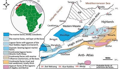
Three unequal extended gulfs were formed in Morocco during the Late Cretaceous (Senonian, according to Choubert and Salvan, 1950) as a result of sea-level fluctuations in the Atlantic Ocean (Figure 1): i); the Phosphate Plateau Gulf of the eastern Meseta or Inter-Atlasic Great Gulf, in the Khourigba-Boulemane-Tendrara area; ii) the Haouz Gulf, from Marrakesh to Essaouira, or ‘‘Sub-Atlasic Northern Gulf” which is separated from the Inter-Atlasic Great Gulf by the Jebilet Mass nearby Bengurir; and iii) the Souss-Ouarzazate Gulf or “Sub-Atlasic Southern Gulf”, which is separated from the Sub-Atlasic Northern Gulf by the rising High Atlas Range. This uplift of the High Atlas started during the Coniacian-Santonian (early Upper Cretaceous of Choubert and Faure-Muret (1962). Afterward, during the latest Cretaceous, the Atlantic-sea receded from a large part of the High Atlas Range (Choubert and Salvan, 1950; Choubert and Faure-Muret, 1962), and then a large transgression of the Atlantic-sea during the Maastrichtian induced the formation of the Gulfs, like “fingers of glove”, following the topography of Jebilet, Rehamna and High Atlas areas. The focus of this article is on the Sub-Atlasic Northern Gulf, which is characterized by the progressive transition from marine, through lagoonal, to continental facies along a west to east transect (Algouti et al., 2015). We propose an updated evolution of the stratigraphic and regional paleogeographic sequence of the northern side of the High Atlas Range of Marrakesh (Morocco) based on a re-assessment of the depositional age of the outcropping Upper Cretaceous (Senonian) formations.
 |
|
Figure 1. Facies map and schematic paleogeographic reconstruction of the Moroccan Atlas region during the Late Cretaceous (modified after Choubert and Faure-Muret, 1960-62). |
- Materials and Methods
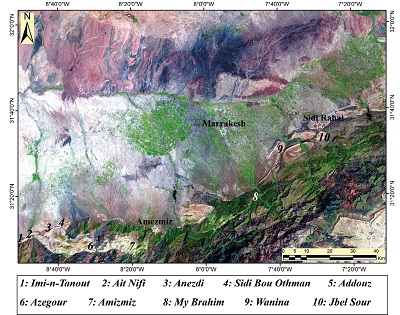
Several field missions were conducted for the paleogeographic reconstruction of the northern side of the High Atlas Range of Marrakesh during the Late Cretaceous. A sedimentological facies analysis to determine the depositional environments was carried out in the field by recognizing sedimentary structures and textures. The lithological characteristics observed in ten selected areas (Figure 2) allowed a lithostratigraphic subdivision in three formations (the Anou-Nfeg Formation, the Aït Abbes Formation, and the Chichaoua Formation, from which synthetic columns are reproduced in Figures 3, 4, and 5, respectively), with a recognition of different types of facies. A correlation panel of the measured columns is shown in Figure 6.
 |
|
Figure 2. Location of the study area and measured sections. |
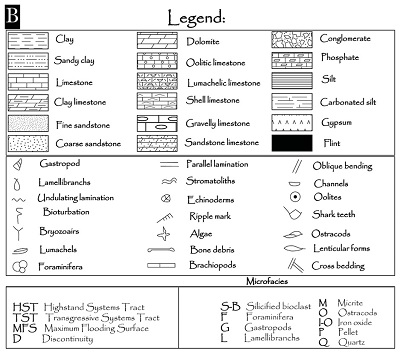
For sampling of unconsolidated materials, the weathered horizon was removed up to about 30 cm deep. After sieving marl, silt, and sandstone samples on 315 μm, 400 μm, and 500 μm sized graded mesh, the residues were studied by scanning electron microscopy at the Cadi Ayyad University laboratory for exoscopic analysis. Thin sections of 250 consolidated rock samples were prepared at the Faculty of Sciences Semlalia of Marrakech and studied under a petrographic microscope in the 2GRNT “Geoscience, Geotourism, Natural Hazards and Remote Sensing” laboratory. The ichnological analysis was limited to outcrop observations. The most marked trace fossils studied in the series (Diplocraterion and Skolithos) were recognized and recorded with photographs and their paleo-environmental significance was deduced from the observed context.
- Results and interpretation
3.1 FORMATIONS AND DEPOSITIONAL SEQUENCES
Three Upper Cretaceous formations have been distinguished on the northern side of the High Atlas Range of Marrakesh, more precisely from Imin’Tanout village in the west to the “Cuvettes area” of Ait Ourir in the east (Figure 2): The Anou-Nfeg Formation, the Aït Abbes Formation, and the Chichaoua Formation (Figures 3A and 3B).
The Anou-Nfeg Formation covers the Cenomanian-Turonian Casbah Formation (Ettachfini, 1993). The Chichaoua Formation underlies (Algouti, 1999; Algouti et al., 1998).
3.1.1. ANOU-NFEG FORMATION
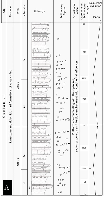
This Formation was nominated by Duffaud et al. (1966). It is about 50 m thick (Figure 3), and it is recognized only in the western part of the investigation field, especially in Imin’Tanout-Seksawa (1 in Figure 2). It consists of dolomitic limestones and marl-dolomite alternations, with some lumachellic levels at the base and it ends with gypsiferous red marls. North of Taroudant, this formation contains Coniacian ammonites: Barroisiceras n. sp., Hemitissotia tursoi Karr and Plesiotissotia dullai Karr. The Anou-Nfeg Formation also contains some ostracods and bryozoans. The following species of ostracods were found: Limburgina selloumensis Vivière, 1985, Ovocytheridea producta Grékoff, 1962, Brachycythere gr. sapucariensis Krömmelbein, 1964 (det. Andreu), Ovocytheridea reniformis Van Den Bold, 1964, O. sp. 780 Donze, O. brevis Grékoff, 1962, O. cf. reniformis, O. cf. brevis, Cytherella gr. ovata Roemer, 1841, Cythereis gr. algeriana Bassoullet and Damotte, 1969, Pterygocythere aff. allinensis Grékoff and Deroo, 1956, and Cythereis aff. morsottensis Vivière, 1985 (det. Bismuth). The bryozoans found are Bifflustrai (Conopeum) sp., which also indicate a Coniacian age (Peron, 1893). Consequently, based on its faunal elements and on lithostratigraphic correlation with the Upper Cretaceous sediments of the southern side of the Western High Atlas (Algouti, 1999; Algouti et al., 1998), the Anou-Nfeg Formation was assigned to the Coniacian.
The Anou-Nfeg Formation covers the Cenomanian-Turonian beds of the Casbah Formation of Agadir (Ettachfini, 1993) by a stratigraphic discontinuity surface, hereafter named D1 discontinuity, which is bioturbated, oxidized, and marked by flint nodules. This Formation includes two lithological units corresponding to the deposition of third-order sequences SI and SII (Units 1 and 2 in Figure 3) and which are bounded by another discontinuity surface between them, hereafter named D2 discontinuity.
 |
  |
|
Figure 3. A) Lithostratigraphic log and sequential evolution of the Anou-Nfeg Formation.B) List of figures (legend). |
THIRD-ORDER SEQUENCE SI
The sequence SI is about 30 m thick, is widely recognized in the Imin’Tanout area and is bounded at the base and the top by the D1 and D2 discontinuities, respectively (Figure 3).
The lower part of this sequence (sub-unit 1 in Figure 3) is characterized by a marl-limestone alternation and ends with a thin, oyster-rich condensed limestone bed (Figure 3). The upper part of this sequence (sub-unit 2 in Figure 3) is characterized by a carbonate-sandstone alternation (Figure 3). The carbonates are limestones with a mudstone texture and bearing ostracods and lamellibranchs at the base (Figure 7, Photo 1), which reveals a calm coastal depositional environment. However, at the top the sediments are barren and show tepee structures, stromatolite laminations, sheet cracks, mud cracks, and monogenic dissolution breccias, which indicate a mesolittoral depositional environment. The sandstones are dolomitic generally, coarsening-downward, lenticular, and having inclined laminations. At the top of this part, the sandstone bodies turn into azoic marls. Effectively, the morphoscopic analysis shows the abundance of rounded grains, which are mostly gleaming and rarely pecked.
THIRD-ORDER SEQUENCE SII
The sequence SII (30 m thick) is bounded by the D2 discontinuity at its base and by a new discontinuity (D3) at its top (Figure 3). The basal discontinuity (D2) corresponds to a noticeable facies change (an abrupt shift from continental sandstones to marine carbonate deposits). The lower part of this sequence (sub-unit 1 of Unit 2 in Figure 3) is marked by the alternation of fossiliferous limestone layers, coquinas in places, generally associated with stromatolitic structures, and azoic sandy marls.
The upper part of this sequence (sub-unit 2 of Unit 2 in Figure 3) is characterized by azoic sand/silt deposits. The quartz grains are mostly rounded having a gleaming surface. The gleaming surface grains reveal an aeolian source with a significant sub-aquatic mixing. The vertical evolution of the sequence SII units records a transition from an intertidal to a supratidal zone where sand dune corridors were accumulated.
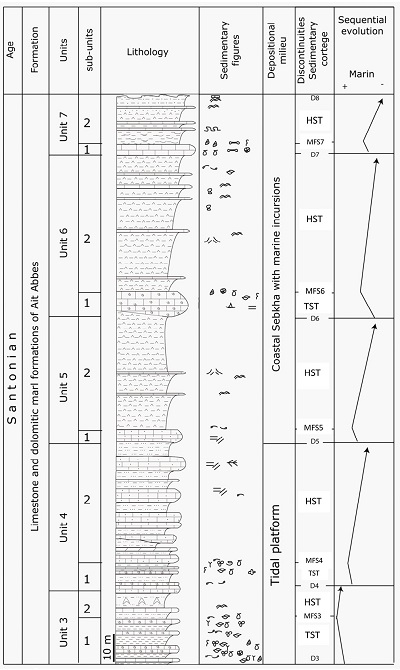
3.1.2 AÏT ABBES FORMATION
This Formation was nominated by Duffaud et al. (1966). It is formed by lumachellic limestones, often, sandstones at the base, then, green-yellow marly dolomitic limestone with some interspersed siliceous limestone beds. Brives (1905) found the ammonite Texanites texanum indicating lower Santonian. The Aït Abbes Formation is recognized over the whole study area. It includes two third-order sequences SIII and SIV bounded by the D3 and D8 discontinuities (Figure 4). Likewise, these sequences comprise several lithological units (Figure 4).
 |
|
Figure 4. Lithostratigraphic log and sequential evolution of the Aït Abbes Formation. |
Due to its lithostratigraphic correlation with the sediments of the southern side of the Western High Atlas (Algouti et al., 1999), and due to the detection of bryozoans, ostracod assemblages, echinoids, and ammonites within this formation, it was assigned to the Santonian. The bryozoans are represented by Flustrina ficheuri (det. P.D. Taylor), which characterizes the Santonian (Peron, 1893). This species has also been detected within the Santonian formations of Tunisia and Algeria (Abdallah, 1987; Matmati et al., 1991).
The ostracod assemblages have been recognized within the Coniacian-Santonian levels of the High and Middle Atlas (Andreu, 1991). As an example, we can mention: Ovocytheridea producta Grékoff, 1962, Cythereis dupliciterornatus Andreu, 1996, Cytherella mediatlasica Andreu, 1996, Cytherella cf. sarakundaensis Apostolescu, 1963, Limburgina selloumensis Vivière, 1985, Cytheropteron piscatorius Andreu, 1996 (det. Andreu), Ovocytheridea sp. B780 Donze, O.aff. brevis Bellion et al., 1973, Spinoleberis yotvataensis Rosenfeld, 1974, Cytherella aff. parallela Reuss, 1846, Protobuntonia aff. numidica Grékoff, 1953, Cythereis magnei Donze and Saint Marc, 1981 (det. Bismuth).
Among the echinoids, Clypeopygus pseudominimus Peron and Gauthier (det. Rey) and Petalobrissus species indicate a Santonian age (Algouti, 1991). One of the found ammonites, unfortunately, is in a poor state of conservation but belongs to the Tissotiidae family (det. Kennedy) which characterizes the Coniacian-Santonian.
 |
|
Figure 5. Lithostratigraphic log and sequential evolution of the Chichaoua Formation. |
THIRD-ORDER SEQUENCE SIII
The sequence SIII includes two lithological units U3 and U4 bounded by the D3 and D5 discontinuities (Figure 4).
A) UNIT 3
At about 20 m thick, unit 3 extends between the D3 and D4 discontinuities (Figure 4). The D3 discontinuity corresponds to one noticeable facies change (an abrupt shift from terrigenous deposits of the upper part of the Anou-Nfeg Formation to subtidal carbonate deposits of the Aït Abbes Formation). The lower part of this unit (sub-unit 1), about 10 m thick, gradually decreases from west to east and vanishes at the Anezdi area (3 in Figure 2). It is generally characterized by the alternation of the limestone and marl layers, which are thinning-upwards and thickening-upwards, respectively. The faunal elements discovered in this sub-unit 1 are: miliolids, planktonic foraminifera, echinoderms, bryozoans, ostracods, gastropods, bivalves, and brachiopods associated with dasycladaceans algae (Figure 7, Photo 2). The upper part of unit 3 (sub-unit 2), is characterized by the repetition of limestone, gypsum and marl facies in the west. The carbonate beds (centimetric thick layers) are dolomitic and whitish, with (saccharoid texture), and contain some gastropods and stromatolites, while the marls are azoic. To the east, silty facies and sandstone bed intercalations are more frequent, the carbonates become sandy and azoic, and include monogenic dissolution breccias and fenestrae (Figure 7, Photo 3). The overall lithostratigraphic evolution of this unit 3 reveals a change from infralittoral to intertidal and to supratidal environments.
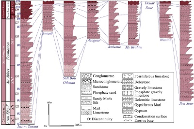 |
| Figure 6. Lithostratigraphic correlations. |
B) UNIT 4
Unit 4 is recognized in most of the study area, but it is absent in Amizmiz, Douar Sour near My Brahim, and at the east of Wanina (Figure 2). Unit 4 is bounded by the D4 and D5 discontinuities (Figures 3 and 5). The D4 discontinuity elsewhere corresponds to an erosive surface and more often to facies change from silty and evaporitic deposits to marine carbonate deposits. Generally, the lower part of this unit 4 (sub-unit 1 in Figure 4) is a metric dolomitic limestone layer including some planktonic foraminifera, bivalves, ostracods, echinoderms, bryozoans, and algae. Eastwards, this layer has a lenticular shape and brecciated appearance including stromatolites, evaporitic dissolution voids, and bioturbation traces. The surface of this layer is covered by a thin ferruginous crust in some places. From west to east, the lithostratigraphic profile of unit 4 reveals a change from a subtidal environment, with a temporary link to open-sea, to a more or less confined intertidal and supralittoral environment.
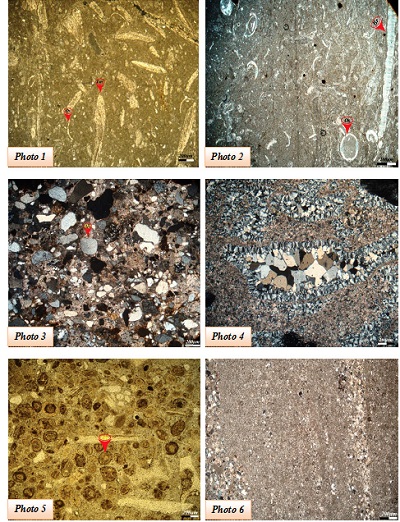 |
| Figure 7. Carbonate microfacies. Photo 1: Biomicrite with lamellibranch bioclasts (Lm) and ostracods (Os) of the Anou-Nfeg Formation (SI). Photo 2: Micrite with ostracods (Os) and bioclasts of brachiopods (Br) of the Aït Abbes Formation (unit 1 of SIII). Photo 3: Carbonated sandstone with poorly sorted, subrounded to angular quartz grains (Qz), Photo 4: Vacuoles filled by diagenetic silica, Photo 5: Phosphate grains (Phs) silicified with carbonate cement, Photo 6: Alternation of lighter detrital and darker micritic laminae. |
The upper part of this unit 4 (sub-unit 2 in Figure 4) is characterized by the alternation of azoic silts, channelized coarse sandstones (Figure 8, Photo 1), and predominating carbonate beds. The thickness of this sub-unit 2 is variable from one region to another (Figures 2 and 6); about 80 m in Imin’Tanout, 94 m in Sidi Bou Othman, and relatively reduced elsewhere (16 m). Westwards of Sidi Bou Othman, the metric carbonate layers are bioturbated and silicified with channelized aspects (Figure 8, Photo 2). They are gravelly and dolomitic with a wackestone texture, bivalve bioclasts, and dissolution vacuoles evidencing pre-existing evaporites. Furthermore, these carbonates display some horizontal laminations, oblique laminations, and herringbone structures suggesting that the sedimentation was dominated by tidal currents (Figure 8, Photo 3). Eastwards, these carbonate beds are whitish, thin- to very thin-bedded, azoic, dolomitic, and evaporitic, and show in some places large tepee structures (Figure 8, Photo 4) associated with the dissolution breccias, cavernous facies (cargneule) with local collapses, large desiccation cracks, and water-escape figures.
These carbonates were deposited in a tidal-flat environment ranging from intertidal to supratidal with brines, which are frequently emerged in the eastern area. From their lenticular aspect, the silts indicate marine sedimentation in shallow waters.
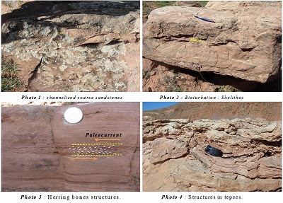 |
| Figure 8. Sedimentary figures and structures found in the Aït Abbes Formation. Photo 1: Coarse-grained channeled sandstone; Photo 2: Skolithos type bioturbation in sandstone beds; Photo 3: Herring bone structures; Photo 4: Tepees structures in carbonate levels. |
THIRD-ORDER SEQUENCE SIV
The sequence SIV is about 100 m thick and is recognized over the study area except for Douar Sour area (Figure 2). The sequence SIV consists of three lithological units: unit 5, bounded by the D5 and D6 discontinuities; unit 6, bounded by the D6 and D7 discontinuities; and unit 7, bounded by the D7 and D8 discontinuities. The D5 discontinuity is a great regional erosional surface with abrupt facies change from supratidal or continental gypso-detrital to subtidal carbonate deposits. The D6 and D7 discontinuities are associated with rapid facies changes from evaporitic to carbonate layers containing ostracods, gastropods, bivalves, echinoids, and fish teeth. Carbonates facies indicate an increasing water level and agitation in shallow subtidal environments. In terms of lithology, units 5, 6, and 7 are relatively monotonous and made of a succession of carbonates, gypsum, marls, and silts.
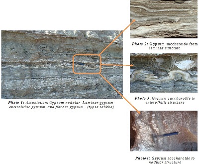 |
| Figure 9. Gypsiferous structures found in the Aït Abbes Formation (eastern area) within the SIV. |
The carbonates are centimetric platy (sandy or dolomitic) limestone layers with a mudstone texture. Sometimes they contain, some bivalves, stromatolites of LLH type (laterally linked hemispheroids: Logan et al., 1974), fenestrae, sheet-cracks, tepees, vacuoles formed after dissolution of halite, radial calcined anhydrite, and silicification traces (quartzine, lutecite, chalcedony, mosaic megaquartz, microcrystalline quartz (Figure 7, Photo 4). These platy limestones characterize a shallow, intertidal to supratidal, restricted environment with a high salinity, affected by repeated emersions probably under hot and humid climates (Afenzar and Essamoud, 2020). Furthermore, according to Cussey (1979), the most sedimentary structures identified within platy limestones indicate carbonated sabkha-type environment. The gypsum layers are generally whitish, with saccharoid textures and laminated, nodular, and enterolithic structures (Figure 9, Photos 1-4). According to Kinsman (1969) and Shearman (1978), this type of facies indicates an evaporitic environment of sabkha-type. The marls and silts are often reddish to greenish, gypsiferous and azoic, locally showing siliceous nodules. This type of facies characterizes a supratidal restricted environment. Consequently, the sequence SIV documents a restricted environment of sabkha-type under a hot and humid climate (Afenzar and Essamoud, 2020). On the other hand, the sequence SIV is presented essentially by thick sandy-silty and conglomeratic detrital deposits in Ait Nifi, Anezdi, Amizmiz, and in the western part of Jebel Sour. These deposits indicate the existence of mountains as the sedimentary source. The exoscopic study of the quartz collected from Amizmiz area provides valuable insights into the environmental evolution. Indeed, the quartz grains collected from the base of the sequence show some uniform surfaces with shock traces (Figures 10A and 10B). Furthermore, the dissolution figures (Figure 10C) around the edges and cavities, and the globular silica deposits within cavities (Figure 10D) indicate an intertidal environment (Le Ribault, 1975). However, the quartz grains collected from the top of this sequence show some violent shock traces and a high polishing, reflecting a fluvial heritage. Moreover, the presence of the flower-like silica with diatomaceous sequestration indicates subaerial exposure in a confined supratidal environment over a long period.
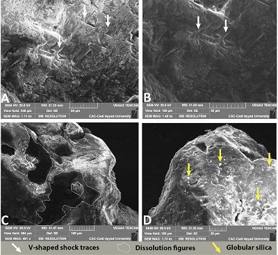 |
| Figure 10. Exoscopy of quartz grain from sandstones of the SIV of the Aït Abbes Formation in the Amizmiz area SIV. (A and B) V-shaped shock traces, (C) Dissolution figures, (D) Globular silica. |
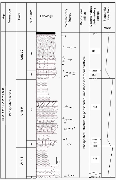
3.1.3 CHICHAOUA FORMATION
The Chichaoua Formation was named by Duffaud et al. (1966) and is also known as Phosphatic Series as it is characterized by phosphatogenesis (Slansky, 1980). It was traditionally reported to the Maastrichtian (Roch, 1930), which is confirmed by ammonites dating: Baculites cf. boulei Collignon, Nostoceras sp. and Baculites sp anceps. Lemarck. This dating was confirmed by the occurrence of shark remnants Ganntouria variabilis Noubhani, 1993, Ginglymostoma botmaense Noubhani, 1993, G. pectinatum Noubhani, 1993, and Plicatoscyllium youssoufiaense Noubhani, 1993, within the phosphated series of the Moroccan basins (Noubhani, 1993). The Chichaoua Formation is recognized over most parts of the study area except in the Amizmiz and Douar Sour areas. Three third-order sequences were distinguished within this formation: SV (Unit 8), SVI (Unit 9), and SVII (Unit 10). The sequence SV (about 10 m thick) is recognized in the Imin’Tanout and Azegour areas (Figure 2) and is bounded by the D8 discontinuity at the base and the D9 discontinuity at the top. Generally, the D8 discontinuity is an erosional surface in the Imin’Tanout area, where it is associated with rapid evaporitic to phosphatic facies changes, while it is represented by a karstified surface in Azegour area. The Sequence SVI (about 20 m thick) is observed in the Imin’Tanout, Azegour, and “Cuvettes area” of Ait Ourir (Figure 2). It is restricted by the D9 and D10 discontinuities, which are both represented by rapid facies changes accompanied by erosional surfaces. The sequence SVII (about 10 m thick) is recognized in the whole study area except in the Amizmiz and Douar Sour areas and is bounded by the D10 and D11discontinuities. The latter is mainly a bioturbated, oxidized, and karstified surface, in which the centimetric and metric irregular cavities are overfilled with some coarse sediments. D11 is a regionally omnipresent discontinuity, noticeably also recognized in Algeria (Belkodja et al., 1994), Tunisia (Abdallah, 1987; Matmati et al., 1991), and Greece (Pomoni-Papaioannou and Solakius 1991). Each sequence generally begins with a centimetric to metric fining-upwards deposit of its phosphatized and bioturbated microconglomerate that contains foraminifera, fish teeth, and other vertebrate bone debris, with an erosional basal surface and overlaid by an accumulation of oysters. In addition, each sequence ends by an alternation of channelized, fining-upwards microconglomerates, phosphatized and bioturbated sands (Figure 7, Photo 5), and carbonates. The sands show some oblique laminations, herringbone structures, and mega-ripples in the Aït Nifi-Anezdi area. The carbonates are represented by some phosphatized, fossiliferous, and bioturbated (skolithos) calcarenites or by dolomitic, fossiliferous, and bioturbated centimetre-thick platy limestones.
In the eastern part, the carbonates are represented by dolomitic and more or less silty mudstones/wackestones containing some ostracods and dissolution voids (vacuoles), which indicate evaporitic depositional environments. The limestone plates display some horizontal and undulated laminae, stromatolites (Figure 7, Photo 6), brecciations, micro-channels, lenticular bedding, tepees, water-escape figures, silicified levels as centimetric nodules or laminae, and Diplocraterion burrows. According to Seilacher (1967), these sedimentary structures are typical of a coastal and infralittoral environment exposed to moderate or relatively high energy conditions.
In summary, the Chichaoua Formation is characterized by phosphatic sedimentation within a restricted and hypersaline environment, which was influenced by the temporary marine incursions under a hot and humid climate, suitable for marine vertebrate fauna. The depth of this environment ranged from shallow to intertidal to deeper subtidal waters. The intertidal zone was influenced by hot periods promoting dolomitization and mixed sedimentation of carbonates and phosphates, while the subtidal zone was characterized by the sole sedimentation of phosphates.
3.2 PALEOGEOGRAPHIC AND GEODYNAMIC EVOLUTION
During the Coniacian (SI and SII), the eastern part of the study area from Ait Nifi to Jebel Sour (Figure 2) was emergent while the western part (precisely from Imin’Tanout to Seksawa) drowned to an intern infralittoral to supralittoral environment, episodically connected to the open-sea (Figure 12). This paleogeographic scheme indicates a major regression related to a pre-Coniacian tectonic phase that was responsible for the subaerial exposure of wide parts of northern Africa. However, this tectonic phase is not recorded in the “Casbah of Agadir” and “Anou-Nfeg” Formations. At the beginning of the lower Santonian (SIII), the sea had transgressed progressively from west to east over the Imin’Tanout, Seksawa, and Sidi Bou Othman areas (Figure 12).
At the end of the lower Santonian (SIII), the transgression was more important and reached the eastern end of the study area, notably the “Cuvettes area” of Ait Ourir (Figure 12). This transgression was followed by a second phase of tectonic instability that structured the whole region into shoals (Aït-Nifi Anezdi), low emerged lands (Amizmiz, Douar Sour and Jebel Sour), and some small restricted shallow basins. Indeed, this transgression covered from west to east the “My Brahim” and “Wanina” shallow basins. The “My Brahim” basin is separated from Sidi Bou Othman’s western shallow basin by the emergent land of Amizmiz. The Wanina basin is separated from My Brahim basin by the emergent land of Douar Sour (Hadach et al., 2017 and Algouti et al., 2017).
 |
|
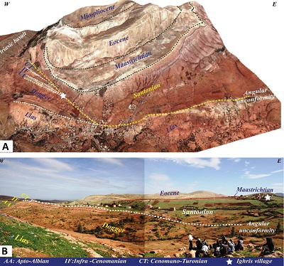
Figure 11. An angular unconformity encountered at the basin of Jbel Sour. (A) An image, through Google Earth, showing the Jbel Sour basin with a beveling to the east of almost all the Mesozoic series (Dogger, Apto-Albian, Infra-Cenomanian and Cenomano-Turonian), The Late Cretaceous (Senonian) is angularly unconformable with the rest of the cover. It shows a reduced thickness in the west, which becomes significant towards the east. (B) A panoramic view of the western part of the Jbel Sour basin showing the Late Cretaceous (Senonian) deposited in an angular unconformity on the rest of the Mesozoic cover. |
The second tectonic phase is recorded by an angular unconformity between the Upper Cretaceous deposits (SIV) and the rest of the Mesozoic cover of Jebel Sour and Sidi Bou Othman (Figure 11, Photos A-B; see also Algouti et al., 2016, 2018), and by the presence of some microfaults, monogenic breccias, and paleolandslides. The upper Santonian deposition (SIV) is marked by an important peneplanation of the whole region (Figure 12), related to the decrease of the water level in a confined environment of sabkha-type due to the hot and humid climate (Hadach et al., 2015, Afenzar and Essamoud, 2020). During this period, higher subsidence induced the deposition of a thick evaporitic series in the west (Imin’Tanout area) and in the east (Jebel Sour area). During the early Maastrichtian, a third tectonic phase accentuated the pre-existing reliefs (high rises and emergent land), especially those of Sidi Bou Othman, Amizmiz, Douar Sour, and Jebel Sour. In the whole region, the Santonian sediments are directly overlain by the Maastrichtian sediments, evidencing a sedimentary gap during the Campanian. During the Maastrichtian (SV, SVI and SVII: Figure 12), the Atlantic eustatic transgression had covered the whole region (Roch, 1930; Algouti, 1999) and reached, at south-east and east, the Saharan Platform, southern Tunisia, and eastern Egypt.
The sediments are unconformable, lying over the former deposits especially in Chichaoua and Jbel Sour. The Maastrichtian subtidal and mesolittoral deposits were deposited, from west to east, into several aligned small confined basins, suitable for phosphate deposition (Sidi Bou Othman, My Brahim, Wanina and Jebel Sour).
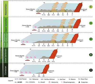 |
| Figure 12. Paleogeographic evolution of the Late Cretaceous of the Northern side of the High Atlas Range of Marrakesh. |
- Conclusions
The reassessment of the Senonian Formations of the High Atlas nearby Marrakesh led us to obtain some new sequence stratigraphic and paleogeographic data:
1) The Anou-Nfeg Formation, which includes two depositional sequences (SI and SII), was assigned to the Coniacian on the basis of ostracod assemblages.
2) The Aït Abbes Formation is also divided into two sequences (SIII and SIV) and, due to its faunal composition of bryozoans, ostracods, echinoderms, and ammonites, was assigned to the Santonian.
3) The Chichaoua Formation was assigned to the Maastrichtian age due to the presence of selachian faunas and includes three depositional sequences (SV, SVI and SVII). The Campanian Oued Lahouar Formation was not detected in the area.
4) Even if the role of eustasy is beyond doubt, three tectonic phases strongly impacted the sedimentary record in the area.
5) The first phase (ante-Senonian), was responsible for an important regression in the eastern area and promoted subsidence in the western area during the Coniacian. According to Floquet (1984), who made a correlation of the sedimentary discontinuities of the Upper Cretaceous Mesogean and Atlantic, the main cause for this Turonian-Coniacian sequence boundary is related specifically to the opening phase of the Atlantic.
6) The second tectonic phase structured the whole region into several high rises and low emergent lands. Several small confined basins were formed in the eastern area during the early Santonian. Effectively, several authors demonstrated the existence of halokinetic processes in the Essaouira basin, which resemble those observed in the eastern Atlantic margin (Jansa and Wiedman, 1982; Ruellan and Auzende, 1985). Moreover, due to the important peneplanation accounted at that time, sebkha-type environment spread over the whole area, and some short marine incursions reached the eastern basins (Late Santonian).
7) The third important regional tectonic phase (ante-Maastrichtian) accentuated the pre-existing paleotopography. During this period, a slow convergence started between Africa and Europe, which was indeed evidenced in the western Mediterranean (Taponnier, 1977). This tectonic phase triggered an important tectonic compression activity in Morocco. This activity is well marked in the southern side of the Central High Atlas Range (Toundout aquifer) (Laville et al., 1977). During the Campanian, the region recognized a sedimentary pause.
8) Indeed, according to Rosenbaum et al. (2000) the convergence between Africa and Eurasia began by c.a. 84 Ma (Santonian) and according to (Guiraud and Bosworth, 1997; Garfunkel, 1998; Guiraud et al., 2005, and Bosworth et al., 2008) this convergence is recorded in northeast Africa by a set of discontinuous compressive events during the Santonian, the end of the Cretaceous and the middle-late Eocene. Moreover, following the Santonian tectonism, an extensional (rifting) phase occurred in Central and North Africa, spanning from Campanian to Maastrichtian or Paleocene times (Guiraud and Bosworth, 1997).
9) During the Maastrichtian, eustatic rise, a marine transgression from the Atlantic Ocean flooded the area of the former (Late Santonian) small confined basins. During this period, essentially the phosphatized sands were deposited unconformably on the whole Cretaceous deposits.
This Maastrichtian transgression is related to the ante-Maastrichtian embryonic phase, and was accompanied by an erosional surface covered by coarse-grained sediments, generally (micro) conglomerates. In addition, the presence of the synsedimentary faults detected at the base of the Maastrichtian was certainly the result of tectonic events that, as well as a formation of angular unconformities, accounted between the Campanian and the deposition of the phosphate series (Chichaoua Formation).
The latter is best recorded at:
* Chichaoua where the Maastrichtian is directly laid on the Casbah formation of Agadir;
* Timahdit, where the Danian lays unconformably on all of the Cretaceous and Jurassic terms until it reaches the Lower Jurassic;
* And Meskala where an unconformity between the Campanian and the Maastrichtian was observed (Ambroggi, 1963).
10) In our study area, this tectonic phase is accompanied by a second halokinetic activity, which will accentuate the pre-existing Santonian reliefs. The study area behaves, then, in small sedimentary basins showing lagoon-brackish influences and functioning as morphological traps facilitating the precipitation of phosphate in a hot and arid climate, an environment that favored the development of vertebrates.
11) The end of the Maastrichtian is marked by a hardened, generally karstified surface, the result of the sea retreating during this period. It is a very extensive regional discontinuity that can even be encountered beyond Morocco, for example in Algeria (Belkodja et al., 1994), Tunisia (Matmati et al., 1991), and Greece (Pomoni-Papaiouanou and Solakins, 1991).
Furthermore, the mass extinction of living beings, occurring on a global scale during this period, was probably due to the regression at the end of the Cretaceous (Ginsburg, 1984).
Contributions of authors
Ahmed Algouti and Abdellah Algouti: investigation, methodology, writing-original draft Validation, writing-review and editing, supervision. Fatiha Hadach: investigation, methodology, writing-original draft. Farah Abdelouhed: investigation, methodology, writing-original draft. Ali Aydda: investigation, methodology, writing-original draft. The authors read and approved the final manuscript.
Financing
No specific funding has to be declared for this work.
Acknowledgments
We would like to express our sincere gratitude to P. D. Taylor, B. Andreu, J. Rey, and Bismuth for the identification of the following fossils (bryozoans, ostracods, and echinoderms). The authors are also grateful to the journal editor, Pr. Essamoud Rachid, Pr. Agustín Martín Algarra and anonymous reviewers for their valuable comments and suggestions.
Conflicts of interest
The authors declare that they have no competing interests.
References
Abdallah, H., 1987, Le Crétacé supérieur de la Chaîne Nord des Chotts (Sud Tunisien), Biostratigraphie, Sédimentation, Diagenèse, University of Bourgogne, Dijon, Unpublished, Thesis of 3rd cycle, 255 p.
Afenzar, A., Essamoud, R., 2020, Sedimentological and sequence stratigraphy of the syn-rift Triassic series of the Mohammedia- Benslimane- ElGara- Berrechid basin: MBEB (Moroccan Meseta), Comptes Rendus: Geosciences, 352, 417-441. https://doi.org/10.5802/crgeos.36
Algouti, A., 1991, Turonien supérieur et Sénonien du versant nord du Haut Atlas de Marrakech: Caractérisation sédimentologique et stratigraphique, University of Cadi Ayyad, Marrakech, Unpublished Ph.D. thesis of 3rd cycle, 242 p.
Algouti, A., 1999, Le Sénonien (Coniacien, Santonien, Campanien et Maastrichtien) du Haut Atlas Occidental (Maroc): Sédimentologie, Stratigraphie Séquentielle, Biostratigraphie et Evolution Géodynamique, University of Cadi Ayyad, Marrakech, Unpublished Ph.D. thesis of State, 418 p.
Algouti, A., Algouti, Ab., Taj-Eddine, K., 1999, Le Sénonien du Haut Atlas Occidental, Maroc : Sédimentologie, analyse séquentielle et paléogéographie: Journal of African Earth Sciences, 29(4), 643-658. https://doi.org/10.1016/S0899-5362(99)00121-9
Algouti, A., Algouti, Ab., Hadach, F., 2015, Le Crétacé supérieur de la région d’Imin’Tanout (Haut Atlas Occidentel. Maroc): Sédimentologie, Biostratigraphie et Analyse Séquentielle: European Scientific Journal, 11(24), 182-204.
Algouti, A., Algouti, Ab., Hadach, F., 2016, Mise en évidence d’une phase tectonique au Santonien du versant Nord du Haut Atlas Occidental, Maroc: European Scientific Journal January, 12(3), 107-122. https://doi.org/10.19044/esj.2016.v12n3p107
Algouti, A., Hadach, F., Algouti, Ab., Mourabit, Z., 2017, Paleogeographic history of the Senonian in the High Western Atlas of Morocco. 10th International Symposium on the Cretaceous Vienna, August 21–26, 2017, 8.
Algouti, A., Algouti, Ab., Hadach, F., 2018, Mapping of the Aït Ourir Basin Area (Marrakesh High Atlas): Using Remote Sensing and GIS Techniques. InterCarto-InterGIS 24 Interdisciplinary Conference, Bonn (Germany) 2018.
Ambroggi, R., 1963, Etude géologique du versant méridional du Haut Atlas Occidental et la plaine du sous. Notes et Mém. Serv. Géol. Maroc, 157, 332.
Andreu, B., 1991, Les Ostracodes du Crétacé moyen (Barrémien à Turonien) le long d’une transversale Agadir-Nador (Maroc): Strata, 2(14) 1-765
Belkodja, L., Bignot, G., and Riveline, J., 1994, Age et modalités de la transgression paléocène dans les Aurès (Algérie NE) d’après la coupe d’Elkantara. In 12ème Colloque Africain de Micropaléontologie, Angers, 17.
Bosworth, W., El-Hawat, A. S., Helgeson, D. E., Burke K., 2008, Cyrenaican “shock absorber” and associated inversion strain shadow in the collision zone of northeast Africa: Geology, 36, 695–698. https://doi.org/10.1130/G24909A.1
Choubert, G., Salvan, H., 1950, Essai paléogéographique du Sénonien au Maroc. Notes et Mémoire du Service Géologie du Maroc, 7, 13-50.
Choubert, G., Faure-Muret, A., 1962, Evolution du domaine atlasique marocain depuis les temps paléozoïques. In Livre à la mémoire du Professeur Paul Fallot, La Société géologique de France, Mémoire, Tome 1, 447–527.
Cussey, R., 1979, Anhydrite diagénétique de sebkha carbonatée dans le Tertiaire d’Irak. In Dépôts Évaporitiques: Illustration et interprétation de quelques séquences. Ed., Techn, Paris, 51- 56.
Duffaud F., Brun L., Plauchut B., 1966, Le bassin du Sud-Ouest marocain. In Reyre, D. (Ed.), Bassins Sédimentaires du Littoral Africain. Paris, Association des Services géologiques africains.
Ettachfini, E.M., 1993, Le Vraconien, Cénomanien et Turonien du bassin d’Essaouira (Haut Atlas Occidental, Maroc). Analyses lithologique, biostratigraphique et sédimentologique, stratigraphie séquentielle: Strata, 2(18), 1-245.
Floquet, M., 1984, Discontinuités sédimentaires et corrélations: Exemples dans le Crétacé supérieur mésogéen et atlantique: Bulletin de la Société Géologique de France, 7(6), 1211-1221. https://doi.org/10.2113/gssgfbull.S7-XXVI.6.1211
Garfunkel, Z., 1998, Constrains on the origin and history of the eastern Mediterranean basin: Tectonophysics, 298, 5–35. https://doi.org/10.1016/S00401951(98)00176-0
Guiraud, R., Bosworth W., 1997, Senonian inversion and rejuvenation of rifting in Arabia and Africa: Synthesis and implications to plate-scale tectonics: Tectonophysics, 282, 39–82. https://doi.org/10.1016/S0040-1951(97) 00212-6
Guiraud, R., Bosworth, W., Thierry, J., Delplanque, A., 2005, Phanerozoic geological evolution of northern and central Africa: An overview: J. Afr. Earth Sci., 43, 83–143. https://doi.org/10.1016/j.jafrearsci.2005.07.017
Ginsburg, L., 1984, Théories scientifiques et extinctions des dinosaures: C.R.A.S, Paris, 298 (2) . 317-320.
Hadach, F., Algouti, A., Algouti, Ab., and Mourabit, Z., 2015, Example of paleosebkha littoral deposits of Senonian in the “Basins Zone” of Aït Ourir (Marrakech High Atlas, Morocco: European Scientific Journal, 11 (8), 306-316.
Hadach, F., Algouti, A., Algouti, Ab., Mourabit, Z., 2017, Paleoenvironmental of the senonian of wanina basin: area of Aït Ourir basins, Morocco: International Journal of Innovation and Applied Studies, 20(2), 479-487.
Jansa, L.F., Wiedman, J., 1982, Mesozoïc-Cenozoïc development of the Eastern North American and Northwest Africa continental margins: A comparaison. In Geology of the Northwest African continental Margin, Springer Verlag, Berlin, 215-269.
Kinsman, D.J.J., 1969, Model of formation, sedimentary associations and diagnostic features of shallow water and supratidal evaporites: American Association of Petroleum Geologists Memoir, 53(4), 830-840. https://doi.org/10.1306/5D25C363-16C1-11D7-8645000102C1865D
Laville, E., Lesage, J.L., Seguret, M., 1977, Géométrie cinématique (dynamique) de la tectonique atlasique sur le versant Sud du Haut Atlas marocain: Aperçu sur les tectoniques hercyniennes et tardi-hercyniennes: Bulletin de la Société Géologique de France, 7(3), 527-539. https://doi.org/10.2113/gssgfbull.S7-XIX.3.527
Le Ribaut, L. (1975). L’exoscopie, méthodes et application. In Notes et Mémoires, Total, Compagnie française des pétroles, Asnières, No 12, 231.
Logan, B.W., Hoffman, P., Gebelein, C.D., 1974, Algal mats, cryptalgal fabrics structures Hamelin pool, Western Australia: American Association of Petroleum Geologists Memoir, 22, 140-194.
Matmati, M., Maamouri, A., Belkaj, A., Salaj, J., Donze, P., 1991, Etude stratigraphique et micropaléontologique dans le Crétacé supérieur et le Paléocène de la chaîne Faid-Chaabat El Attaris (Axe Nord-Sud, Tunisie centrale) : Notes du Service Géologique du Tunisie, 57, 35-69.
Noubhani, A., 1993, Les Sélaciens des bassins à phosphate du Maroc (Maastrichtien-Lutétien): Systématique, Biostratigraphie, Évolution et Dynamiques des faunes, University of Montpellier, Montpellier, Unpublished Ph.D. thesis, 293 p.
Peron, A., 1893, Description des invértébres fossiles des terrains crétacés de la région sud des hauts-plateaux de la Tunisie recueillis en 1885 et 1886 par M. Philippe Thomas, 21-23.
Pomoni-Papaioannou, F., Solakius, N., 1991, Phosphatic hard-grounds and stromatolites from the limestone/shale boundary section at Prossilion (Maastrichtien-Paléocène) in the Parnassus-Ghiona Zone, Central Greece: Palaeogeography, Palaeoclimatology, Palaeoecology, 86 (3-4), 243-254. https://doi.org/10.1016/0031-0182(91)90083-4
Roch, E., 1930, Etudes géologiques dans la région méridionale du Maroc Occidental : Notes et Mémoire du Service Géologie du Maroc, 9, 1-542.
Rosenbaum, G., Lister, G.S., Duboz, C., 2002, Relative motions of Africa, Iberia and Europe during Alpine orogeny: Tectonophysics, 359, 117–129. https://doi.org/10.1016/S0040-1951(02)00442-0
Ruellan, E., Auzende, J.M., 1985, Structure et évolution du plateau sous-marin d’Eljadida (Mazagan, Ouest Maroc): Bulletin de la Société Géologique de France, 8, 103-114. https://doi.org/10.2113/gssgfbull.I.1.103
Seilacher, A., 1967, Bathymetry of trace fossils: Marine Geology, 5, 413-428. https://doi.org/10.1016/0025-3227(67)90051-5
Shearman, D.J., 1978, Evaporites of coastal sabkhas. In Dean W.E., Schreiber, B.C,(eds.), Marine evaporates: SEPM Short Course Notes 4, 6-42.
Slansky, M., 1980, Géologie des phosphates sédimentaires: Mém. B.R.G.M., 114, 90.
Taponnier, P., 1977, Evolution tectonique du système alpin en méditerrannée: poinçonnement et écrasement rigide plastique: Bulletin de la Société Géologique de France, 177(3), 437-460.
Manuscript received: April 28, 2021
Corrected manuscript received: November 7, 2021
Manuscript accepted: November 10, 2021
Peer Reviewing under the responsibility of Universidad Nacional Autónoma de México.
This is an open access article under the CC BY-NC-SA license(https://creativecommons.org/licenses/by-nc-sa/4.0/)