
|
Boletín de la Sociedad Geológica Mexicana Volumen 74, núm. 3, A080622, 2022 http://dx.doi.org/10.18268/BSGM2022v74n3a080622
|
 |
Geoarchaeological interpretations of the formation and environment of Samaca H–8, Ica Valley, south coast Peru (c. AD 900–1550)
Interpretaciones geoarqueológicas de la formación y el ambiente de Samaca H–8, Valle de Ica, costa sur de Perú (c. 900-1550 d. C.)
Lady Santana Quispe1,*, Charles French2, David Beresford-Jones3, Carlos Enrique Rengifo Chunga4
1 National University of San Marcos, 1564, Lima, Peru.
2 Department of Archaeology, University of Cambridge, CB2 3DZ, Cambridge, UK.
3 Fellow, Heinz Heinen Centre for Advanced Study, University of Bonn, Heussallee 18–24, D-53113, Bonn, Germany.
4 National University of Trujillo, Jr. San Martin, 380,13001,Trujillo, Peru.
* Corresponding author: (L. Santana Quispe) This email address is being protected from spambots. You need JavaScript enabled to view it.
How to cite this article:
Santana Quispe, L., French, C., Beresford-Jones, D., Rengifo Chunga, C.E., 2022, Geoarchaeological interpretations of the formation and environment of Samaca H–8, Ica Valley, south coast Peru (c. AD 900–1550): Boletín de la Sociedad Geológica Mexicana, 74 (3), A080622. http://dx.doi.org/10.18268/BSGM2022v74n3a080622
Manuscript received: October, 31, 2021; Corrected manuscript received: May 20, 2022; Manuscript accepted: June 8, 2022.
ABSTRACT
Today the Lower Ica Valley (Peru) exhibits evidence of environmental degradation, strong activity of deposition and erosion processes through modifying agents such as water and wind. All of this is the product of a long process of environmental transformation both during and since pre-Columbian times. Archaeological remains present in this valley evidence a long and important pre-Columbian cultural trajectory. We provide a case study of the geoarchaeology of the Samaca H-8 archaeological site that was founded sometime towards the end of the Middle Horizon (c. AD 900-1000) and consolidated its development during the Late Intermediate period (AD 1000-1400). This work contemplates the analysis of soils and sediments using micromorphology, geochemical-geophysical analyzes and radiocarbon dating. The results reveal that the construction and first occupation of Samaca H-8 (or at least the eastern part of the site), during the transition from the Middle Horizon period to the Late Intermediate Period, was marked by environmental dynamics and drastic landscape change toward more arid conditions. Recurrent deposition of windblown materials took place, perhaps due to a lack of protection offered by riparian dry forest cover. The Samaca H-8 site was established under these environmental conditions around AD 900.
Keywords: geoarchaeology, Lower Ica Valley, Samaca-H8, Middle Horizon and Late Intermediate Period.
RESUMEN
En la actualidad, el Valle Bajo de Ica (Perú) exhibe evidencias de degradación ambiental, fuerte actividad de procesos de deposición y erosión a causa de la acción de agentes modificadores como el agua y el viento. Todo ello, producto de un largo proceso de transformación ambiental registrado desde épocas precolombinas. En este escenario, los diversos restos arqueológicos presentes en este valle muestran una larga e importante trayectoria cultural prehispánica. Proporcionamos un estudio de caso sobre la geoarqueología del sitio arqueológico Samaca H-8 que surgió a fines del periodo Horizonte Medio (c. 900-1000 d. C.) y consolidó su desarrollo durante el periodo Intermedio Tardío (1000-1400 d. C.). Este trabajo contempla el análisis de suelos y sedimentos mediante micromorfología, análisis geoquímico-geofísicos y datación radiocarbonica. Los resultados revelan que, la construcción y primera ocupación de Samaca H-8 (o al menos la parte este del sitio), durante la transición del periodo Horizonte Medio hasta el Período Intermedio Tardío, estuvo marcado por una dinámica ambiental y cambio drástico del paisaje hacia condiciones más áridas y con la deposición recurrente de materiales arrastrados por el viento. Tal vez como consecuencia de la falta de protección que ofrece la cubierta de bosque seco ribereño. El sitio Samaca H-8 comenzó a formarse bajo estas condiciones ambientales alrededor del año 900 d.C.
Palabras clave: geoarqueología, Valle Bajo de Ica, Samaca H-8, Periodo Horizonte Medio y Periodo Intermedio Tardío.
1.Introduction
The Ica Valley of the south coast of Peru (Figure 1) has long been important to the development of Peruvian archeology. This region was the cornerstone from which a chronology for the entire Andean region was proposed first by Rowe, Menzel and colleagues (see Rowe, 1962; Menzel, 1971). Despite numerous critiques, revisions and updates, this periodization, better known as Rowe’s Ica Valley Master Sequence (Figure 2) (Rowe, 1960, 1962; Menzel, 1964, 1971, 1976), continues to be used by Andean researchers (e.g., Ramón, 1994, 2005, 2010, 2013; Del Águila, 2010; Tantaleán, 2016). Years of research here have revealed the long pre–Columbian history of the Ica Valley, opening up several lines of study. The valley is widely related to the development of the Nasca culture, of the Early Intermediate Period, which understandably calls the attention of specialists and the general public. This paper, however, centers on a less disseminated period of this region, the Late Intermediate Period —considered to be a span of time in which several Andean regions consolidated locally–based cultural expressions, from a site called Samaca H–8, which emerged by the end of the Middle Horizon and consolidated its development around AD 1000. Moreover, it examines this case study from a geoarchaeological perspective to explore how environmental aspects, alongside anthropogenic interventions, shaped the history of this ancient community.
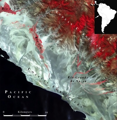 |
| Figure 1. Geological characteristics of Ica, South coast of Peru (Beresford-Jones, 2014). |
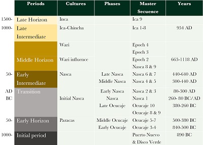 |
| Figure 2. Chronology of the valleys of Ica, Palpa-Nasca and master sequence of the Ica Valley (Menzel 1971). Based on Beresford-Jones (2014); Cadwallader et al. (2015); Cadwallader et al., (2018) and Unkel et al. (2012). |
The Ica Valley, especially its lower, downstream parts (see Figures 1 and 3) (Massey, 1991), preserves abundant archaeological remains that give an account of continuous and intense occupation through time, beginning at least ten millennia ago (Engel, 1991; Beresford–Jones et al. 2015; Beresford–Jones et al., 2018). Research here has focused on understanding general cultural development (Menzel, Rowe and Dawson, 1964; Menzel, 1964, 1971, 1976; Engel, 1981; Massey, 1991; Cook, 1994; DeLeonardis, 1997, 2005; Bachir Bacha and Llanos, 2013), mostly for earlier time periods -the Initial Period (c. 1800–800 BC), Early Horizon (c. 800 BC–AD 100) and Early Intermediate Period (c. AD 100–750)- with less attention paid to later Middle Horizon (c. 700–1000 AD) and Late Intermediate periods (c. 1000–1400 AD) (Figure 2). Moreover, these investigations mostly entail analyses of ceramics and architecture with little information about past landscapes and environments.
 |
| Figure 3. Location of the Samaca basin and the archaeological site Samaca H–8 in the Lower Ica Valley. |
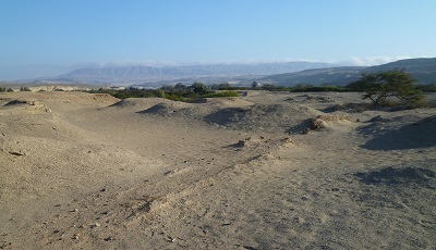
Recently, however, the Samaca Archaeological Research Project (‘PIA Samaca’ by its acronym in Spanish) has carried out many studies in the Lower Ica Valley and published abundant data on societal development throughout the Middle Horizon (MD), Late Intermediate (LIP) and Late Horizon periods (Beresford–Jones et al., 2009a, Cadwallader, 2013; Cadwallader et al., 2015; Beresford–Jones, 2014; Haburaj, 2016; Chauca et al., 2017; Cadwallader et al., 2018; Santana, 2021; among others). Following its development of a non–deterministic environmental approach, the Samaca Project has, over two decades, generated new geoarchaeological, bioarchaeological and archaeobotanical data, which offer new insights into significant and sometimes dramatic changes in the environment and landscape of the Samaca and Ullujaya basins of the Lower Ica Valley, related to extraordinary ENSO (El Niño–Southern Oscillation) event(s), alongside deforestation and consequent geomorphological transformation. According to the archaeological record registered in the eastern flanks of both these basins, it is observed that prior to the Middle Horizon, once active river floodplain terraces were abandoned to productive agriculture (see Figure 4), and a long process of wind erosion in the Samaca and Ullujaya basins began (Beresford–Jones et al., 2009a and 2009b; Beresford–Jones, 2014).
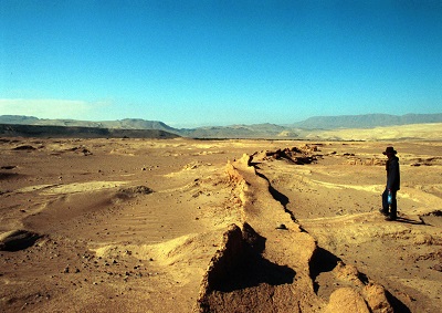 |
| Figure 4. Floodplain terraces had been abandoned to productive agriculture. The figure shows a relict Nasca canal on H–13 (PIAS file). |
Geoarchaeological findings in the south of the Ica Valley in the Palpa–Nasca region register similar changes in the landscape over time. This, together with an apparent lacuna in recorded archaeological sites, has led to the hypothesis of widespread abandonment of the lower parts of the Palpa and Nasca valleys and relocations of their populations elsewhere, driven by climate and environmental changes at the end of the first millennium AD (e.g., Unkel et al., 2009; Soßna, 2015). In this context, research on this time period in the Lower Ica Valley is important since it enables a more complete environmental trajectory and insights into how widely the hypothesis proposed for the Palpa and Nasca valleys might apply for the first centuries of the Late Intermediate Period on the south coast of Peru.
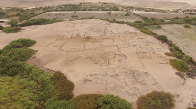 |
| Figure 5. Archaeological site Samaca H–8. Aerial photograph taken by Cesar Durand (PIAS file). |
In this article we focus on Samaca H–8, a well–preserved archeological site located on the eastern bank of the Rio Ica in the Samaca basin and dated mainly to the Late Intermediate Period–Late Horizon (c. AD 1000–1532) yet still occupied into the first decades of the early Spanish Colonial period (Figure 5 and 6). The site’s adobe architecture comprises many groups of small rooms, often linked to larger, open areas and divided by long, narrow passages (Arce et al., 2013, 44). Its surface is covered by dense conglomerations of marine molluscs and pottery fragments along with textile fragments and bivalve molluscs such as Spondylus (Figure 6). Much of its material culture dates to the Late Intermediate Period, but some may belong to styles previous to this period (Arce et al., 2013; Chauca et al., 2017; Santana, 2021).
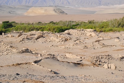 |
| Figure 6. Natural and cultural material exposed on the surface of Samaca H-8. |
Our objective is to characterize the landscape and environment in which Samaca H-8 was first established through a detailed geoarchaeological study of certain deep contexts underlying its initial foundation. For this, we developed a geoarchaeological approach, where geoarchaeology is understood to be a sub-discipline that integrates methods and theories of Earth Sciences and archeology (Butzer, 1989, 2008, 2011; BenitoCalvo et al., 2014; Gilbert et al., 2017), to recognize and understand the implications of the interrelationship between the environment and past societies. However, as Butzer (2008) emphasizes, the development of a geoarchaeological proposal must go beyond the simple fact of applying geo-scientific techniques. Rather, it must presuppose the understanding past geomorphological and sedimentation processes which are critical to understanding both the past environments of archaeological sites and how they are presented to us today (Goldberg and Macphail, 2006; Butzer, 2011; Gilbert et al., 2017).
We therefore present here analyses of soils and sediments underlying Samaca H–8 using methods of physical characterization, micromorphology and geochemical analyses that, together, shed light on the processes which can be associated with both natural and cultural events and factors (e.g., French, 2003, 2015; Holliday, 2004). The calibrated radiocarbon dates, modeled using OxCal Bayesian analysis, provide the geochronological base to these processes and establish the date of the first foundation of Samaca H–8.
1.1. THE LOWER ICA VALLEY: ENVIRONMENTAL AND CULTURAL CONTEXT
Our area of interest focuses on the Samaca basin, which, together with the basins of Ullujaya, Ocucaje, Callango and Montegrande, forms the Lower Ica Valley (see Figure 3). This area is characterized by an extreme environmental juxtaposition (Figure 7): a hyper–arid desert crossed by fertile river oases in the basins along the perennial Ica River and adjacent to one of the richest marine ecosystems in the world (Beresford–Jones, 2014). Today these basins are deserted and largely uninhabited and uncultivated, although there is agriculture in Callango and some efforts have been made to cultivate in Ullujaya and Samaca (Arce et al., 2013). This entire area is integrated into the so–called Peruvian–Chilean Desert or Atacama Desert. Here, distinctive climate, geology, hydrology and geomorphology have configured particular cultural trajectories for what archaeologists refer to as the ‘south coast’ of Peru (Wiley, 1971). The geomorphology of this area presents buried soils, remains of alluvial sediments composed of clay, silt and sand, which are all indicative of frequent periods of flooding and erosion (Beresford–Jones et al., 2009; Hesse and Baade, 2009; Beresford-Jones, 2014; Santana et al., 2021).
 |
| Figure 7. Deflated landscape, buried soils and relics of vegetation cover in the Samaca basin. |
The intermittent rivers of the Peruvian desert coast emerge from the western slopes of the Andes and flow through a narrow coastal strip before reaching the Pacific Ocean (Beresford–Jones, 2005, 2014; Beresford–Jones et al., 2009b). However, the Ica River, located on the southern coast of Peru, presents a different geomorphological configuration (see Figure 1), because its access to the sea is “blocked by the uplifted formations of the Tablazo de Ica, resulting in the river being diverted south, parallel to the coast, for 150 km” (Beresford–Jones et al., 2009b, 238). Another characteristic that this area presents is the strong winds, commonly known as ‘paracas’, that blow persistently from the southeast (Rossel, 1977). Measurements for the Samaca basin show an average air speed between 32.2 kph (October 2004) and 27 kph (December 2004), with the general average for the basin at 28.8 kph (Beresford–Jones, 2014, p. 31). Likewise, rainfall is scarce and only occurring during the months of December to April, with readings indicating that “accumulated annual precipitation is 145 mm” (SENAMHI, 2021, 63).
In this environmental context, important pre–Columbian cultures emerged (see Figure 2) including Paracas and Nasca (c. 200 BC–AD 600), and Ica (c. AD 1000–1438 or LIP). At different times the cultural trajectory of the Ica Valley was also influenced by the Wari State (AD 600–1000 or MH), with its capital Huari located near Ayacucho in the southern highlands of Peru; and, later, the Inca Empire, with its capital in the current city of Cusco, also in the southern highlands. The archaeology of the Lower Ica Valley, like that of the south coast region more widely, therefore presents a vast cultural development evidenced by diverse settlements built through time (Massey, 1991). Present–day environmental and landscape conditions might perhaps seem unfavorable for a long and complex cultural development. However, we must keep in mind that “the [current] ecological conditions show very poor conservation, and do not necessarily represent the conditions of the past” (Cook, 1994, 65; our translation).
1.2. EL NIÑO–SOUTHERN OSCILLATION (ENSO)
The Ica Valley, like other parts of the Peruvian coast, is impacted by the effects of the periodic El Niño–Southern Oscillation (‘ENSO’) phenomenon. El Niño cycles typically occur in a time period of two to ten years, causing ‘interannual climate variability’ with a tendency to increase sea surface temperature (‘SST’) (SENAMHI, 2014). Variations in the frequency and intensity of SST can have powerful influence on human populations and their subsistence. During the major ENSO of summer 2017, for instance, heavy rainfalls and flooding affected large part of the usually arid landscape of the Peruvian northern and central coast. The 1997–1998 El Niño, on the other hand, was one of the most powerful events of the last 30 years and had particular impact on the south coast (Beresford–Jones, 2014; SENAMHI, 2014; Sandweiss et al., 2020). The city of Ica suffered floods and the partial destruction of its infrastructure, while, in the Samaca basin, the Late Intermediate archaeological site of H–9 was washed away by river floods (Beresford–Jones, 2014). Consequently, ENSO is the focus of many new lines of interdisciplinary research which aim to evaluate the relationships between “climate variability and human activities” (SENAMHI, 2014, 22).
These lines of research engage with Andean archaeology in a special way, as many archaeologists have long tried to argue for a direct relationship between devastating ENSO episodes and social dynamics along the Peruvian coast (Nials et al., 1979; Moseley and Feldman, 1982; Sandweiss et al., 2001; Contreras 2010; among others).
However, over time, these investigations have become more refined (Beresford–Jones et al., 2009b; Sandweiss and Kelley, 2012; Machtle and Eitel, 2013; Beresford-Jones, 2014; Carré et al., 2014; Sandweiss et al., 2020; among others), especially through the development of an interdisciplinary approach. Nevertheless, the development of other studies and discussions that allow us to understand and clarify that not all flood deposits registered in sedimentological stratigraphies are necessarily consequences of El Niño, as normally done in Central Andean archaeology, are still pending (Ortlieb and Vargas, 2003; Beresford–Jones et al., 2009b; Beresford–Jones, 2014; Uceda et al., 2021).
- Geoarchaeological Research on the South Coast of Peru
Most of the archaeological research contemplating an environmental approach in the basins of the Lower Ica Valley, developed by the PIA Samaca, Beresford–Jones and collaborators, offer accounts of geomorphological changes through time (Beresford–Jones et al., 2009b; Beresford–Jones, 2014). These, in turn, have been correlated with archaeological contexts, such as the aforementioned river terraces of the various Early Horizon to Middle Horizon contexts, that have become extinct over the now abandoned river terrace areas denoted as H–13 (Samaca basin) and G–8/9 (Ullujaya basin) (Beresford–Jones, 2005; Beresford–Jones et al., 2009b, Beresford–Jones, 2014). Geomorphological and micromorphological studies have revealed the past occurrence of high–energy flood episodes with deposition of alluvial sediments, alternating with dry periods and higher wind deposition, suggesting an open environment undergoing a gradual process of aridification (see Figure 4 and 7) (Beresford–Jones et al., 2009a and b; Beresford–Jones, 2014; French, 2015; Santana et al., 2021). Fragments of a fluvial layer up to 60 cm thick are recorded at various locations below the H–13 terrace, which in digital elevation model (DEM) reconstructions suggest an ancient flood event of far greater spatial extension across the Samaca Basin than the one in the 1997/8 El Niño, occurring sometime towards the end of the Nasca–Early Intermediate Period (EIP) (Beresford–Jones et al., 2009b; Beresford–Jones, 2014). Later, “at some time in the past the river has incised into its floodplain, exposing the five–meter embankment described as Section 1/013 and creating the H–13 relict terrace” (Beresford–Jones et al., 2009b, 245). Likewise, the presence of extensive but varying calcium carbonate concretions on the currently dry surfaces of H–13 along with ‘cemented’ anthropogenic features such as canals, suggest human intervention in this part of the basin through probable water manipulation (Beresford–Jones et al., 2009b). In addition, archaeobotanical studies, palynological analysis and plant macrofossils suggest that both basins (especially the H–13 and G–8/9 terraces) supported agriculture during the Nasca–Early Intermediate Period as shown by the presence of a wide repertoire of crops that are characteristic of the south coast: cotton, corn, lima beans, chili, cucurbits, etc. (Beresford–Jones, 2005; Beresford–Jones et al., 2009a; Cadwallader, 2013; Beresford–Jones, 2014). All these occur within a landscape composed also of Prosopis sp, (huarango) woodland, the trunks of which are found in situ during excavations. Through time, however, investigations revealed a gradual disappearance of these forests as a consequence of the intensification of agriculture, especially during Late Nasca–EIP and the early MH period (see Figure 2). By the end of the Middle Horizon, these parts of the landscape of both basins had become degraded, without vegetation cover and exposed to the effects of geomorphological processes triggered by ENSO events (Beresford–Jones, 2005; Beresford–Jones et al., 2009a; Beresford–Jones, 2014).
Although it is argued that these processes became more accelerated due to ENSO–induced climatic fluctuations at the end of the Nasca–EIP, they were also induced by anthropogenic factors. Particularly, it is suggested that they arose out of changes in Late Nasca society and with the arrival of a new Wari political order (Beresford–Jones et al., 2009a; Beresford–Jones, 2014), caused by the socio–economic and political transformations that the area underwent since the end of the Early Intermediate to the Middle Horizon. In sum, intensifying agriculture and ceramic production caused the removal of extensive dry forests and riparian vegetation which had protected these basins from the impacts of extreme ENSO cycles (Beresford–Jones et al., 2009b). Changes in the landscape of the Samaca and Ullujaya basin are evident by the MH, as their alluvial terraces were abandoned and reused thereafter (late MH and during the LIP) as cemeteries (Cadwallader et al., 2015).
Cadwallader et al. (2018) studied and dated a number of disturbed funerary contexts for the Samaca and Ullujaya basins to argue that changes in the location patterns of funeral contexts (mainly during the first millennium BC) correspond to processes of landscape change. Burials belonging to periods ranging from the Early Horizon to the Late Intermediate Period were located along “the western edges of the basins” (Cadwallader et al., 2018, 14), beyond the margins of arable land. It is highly significant that after the Nasca–EIP the river terraces which had formerly been agricultural spaces became cemeteries during the Middle Horizon and Late Intermediate Period, demonstrating that they presented a dry landscape of high terraces devoid of vegetation or crops. Finally, Haburaj (2016) developed a spatial–temporal analysis of the settlements along the Ica River using a geographic information database and statistical analysis to argue that changes were generated in the settlement pattern throughout the Ica River basin due to repeated climatic fluctuations. Thus, from the Early Horizon to the Late Intermediate Period, the locations of the sites were related to general arid or humid climatic conditions (Haburaj, 2016, 55).
South of the Ica Valley, the DAI’s Nasca–Palpa Archaeological Research Project used a multidisciplinary research approach including geoarchaeology to characterize the environmental evolution of this part of the Peru–Chile Desert. The project used various proxy–data such as sediment studies, geological analysis and loess dating by OSL, to argue for the past existence of alternating more humid and arid landscapes over time (Eitel et al., 2005; Unkel et al., 2007, Hesse and Baade, 2009; Mächtle and Eitel, 2013; Mächtle et al., 2017). These alterations were related to past increases in rainfall as a consequence of monsoon fluctuations over Amazonia (Eitel et al., 2005). Thus, during the Middle Holocene, they argue that this region would have experienced more humid conditions (6.42 ± 0.53 ka; see Eitel et al., 2005, 151), with some rainfall on lower Andean slopes, open grasslands and a retired desert margin. Their model would have a first period of aridity occurring just before the development of the Paracas culture (c. 800–200 BC–Early Horizon), followed by another period of humid conditions during the development of the Nasca culture, especially during the Early and Middle Nasca phases (see Figure 2). These conditions changed towards a steady process of aridification during the Late Nasca and, finally, culminated in an arid landscape during the Middle Horizon (Eitel et al., 2005; Unkel et al., 2007). Similar processes are also evident in the Lower Ica Valley, although, as we saw previously, attributed here also to human-induced factors triggering change (cf. Hesse and Baade, 2009). Arid conditions in Nasca–Palpa were interrupted by more humid ones during the Late Intermediate Period (AD 1000–1400) according to this model; finally, from the 15th century onwards, they became arid again (Eitel et al., 2005; Mächtle et al., 2017).
The apogee of cultures such as Paracas and Nasca is attributed to this climatic alternation, but also, to the collapse of Nasca during the Late Nasca phase (AD 400–600), that is, during the second aridification period. At the same time, the reappearance and emergence of new settlements during the Late Intermediate Period is credited to the local impacts here of the so–called Little Ice Age (Unkel et al., 2007). According to this model, landscape and environmental changes on this part of the south coast are not attributed to El Niño events or to anthropogenic factors, but rather to the variable influence of the South American Summer Monsoon (Eitel et al., 2005; Unkel et al., 2007). Consequently, it is considered that climatic variations influenced the development and adaptive forms of pre–Hispanic societies.
- Materials and Methods
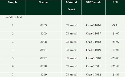
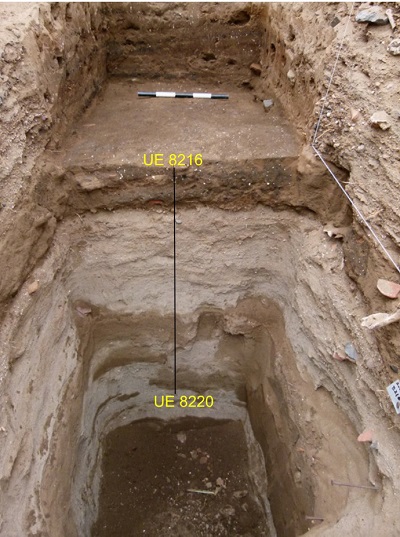
Between 2013 and 2015, the PIA Samaca carried out systematic surveys and sampling for geoarchaeological purposes from various locations in the Samaca–Ullajaya and Callango basins. This approach included taking samples from the east profile of Trench 3 in the Samaca H–8 site (Figure 8). Trench 3 (also known as ‘Pozo 3’; see Arce et al., 2013) is located on the western edge of the site, where extraordinary flooding of the Río Ica during the 1997–98 ENSO exposed a 4.5 m deep section of the site. This was cleaned by excavating a profile into the section measuring 2 m wide by 5 m long with an east–west orientation. The objective was to obtain a stratigraphic sequence that reveals the timeframe in which the site was occupied (See Figure 9). Seven of the Trench 3 contexts were dated with the C14 (Table 2). Most of these contexts were composed of midden materials including ceramic fragments, obsidian lithics, animal bones, desiccated plant remains, marine mollusk and land snail shells (Arce et al., 2013; Santana, 2021). The base of the Trench 3 excavation comprised of ‘made ground’ devoid of cultural materials and laying directly on top of natural river sand deposits. These contexts are the particular focus of the geoarchaeological analyses described here. The entire Trench 3 sequence thus appears to represent the history of Samaca H–8 from it first foundation.
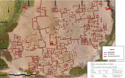 |
| Figure 8. Plan of Samaca H–8 with the trenches dug during the 2013 and 2017 seasons. Drawn by George Chauca (PIAS file). |
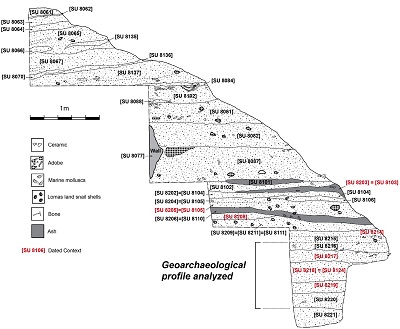 |
| Figure 9. Trench 3 and East profile excavated in Samaca H–8. |
3.1. MICROMORPHOLOGY
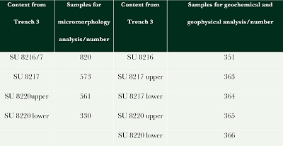
Micromorphology is the microscopic study of thin sections obtained from undisturbed soil and sediment samples collected in blocks and consolidated by impregnation in polyester resin (Courty et al., 1989). Our research was based on the observation and study of thin sections. The samples were extracted from the stratigraphic profile exposed by excavation of Trench 3, Samaca H–8 (Figure 9 and 10). Four blocks for micromorphological analysis (after Murphy, 1986; Courty et al., 1989) were taken (see Table 1) from three stratigraphic units (‘SU’s): from top to bottom SU 8216, SU 8217, SU 8220. They correspond to periods of initial occupation and pre–foundation (levels prior to occupation) of the site, respectively (see Figure 9). These were analyzed by Charles French at the Department of Archaeology, University of Cambridge.
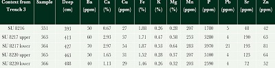
| Table 1. Samples for geoarchaeological analysis. |
 |
3.2. GEOCHEMICAL AND MAGNETIC SUSCEPTIBILITY ANALYSES
Multi–element analyses1 were developed using a 35–element inductively coupled plasma atomic emission spectroscopy (ICP–AES) instrument after treating the samples with the aqua regia method (Wilson et al., 2008; Oonk et al., 2009) and applied to five samples (10 grams each) from the same stratigraphic units previously listed (Table 1).
Magnetic susceptibility is a measure of the ability of a soil or sediment to become magnetized when placed in a magnetic field and is a rough measure of iron and other ferromagnetic components (Clark, 1996). Five samples taken from the stratigraphic units 8216, 8217, 8220 underwent the magnetic susceptibility analysis (see Table 1).
1 www.alschemex.com and https://www.alsglobal.es/
3.3. RADIOCARBON DATING
Seven contexts from Trench 3 were radiocarbon dated at Oxford University Radiocarbon Acceleration Unit (‘ORAU’), and then calibrated using ShCal20 (Hogg et al., 2020). The dates of these contexts show general correspondence with their stratigraphic sequence (see Table 2 and figure 9).
| Table 2. Samples for radiocarbon dating of Samaca H–8, Trench 3. |
 |
However, given their overall midden context2 they are modeled here as a single contiguous phase using OxCal v4.4.4 Bayesian analysis (following Bronk Ramsey, 2009) to define boundary limits for Trench 3 stratigraphy (see Table 5 and Figure 15). These dates are complemented by those from other areas of the Samaca and Ullujaya basins, as well as previous geoarchaeological studies already outlined (Beresford–Jones et al., 2009a and 2009b; Beresford–Jones, 2014; Cadwallader et al., 2015; Cadwallader et al., 2018; Santana et al., 2021; Santana, 2021).
2 The radiocarbon dates were obtained from various contexts of Trench 3. Generally, these show correspondence with stratigraphy (deeper contexts give older dates), but in a few cases contexts apparently stratigraphically above others, nevertheless have an older date. That is because the stratigraphy at those points has been disturbed in the past. There are various archaeological contexts exposed in Section 3 (some walls etc.), but in general these contexts seem to be rubbish middens. So, in those circumstances the most conservative statistical measure of the age of the overall Trench 3 midden is to model all the dates as a single contiguous phase and use the boundaries of that phase to estimate the earliest and latest ages of the midden.
- Results
4.1. MICROMORPHOLOGY AND CHARACTERIZATION OF TRENCH 3 OF SAMACA H–8
Four samples were taken from possible old land surface horizons exposed in the basal 2 m of the Samaca H–8 deep section (see Figures 9 and 10). These possible old surfaces are interrupted by thick units of fine–medium quartz sand. The base of the step trench profile was characterized by fine pebbles and coarse sand of a former river channel, before sand was deposited, with a fining upward sequence over a depth of c. 30 cm. The uppermost unit of this basal sequence (SU 8220) could be the original surface on which settlement at H–8 took place.
 |
| Figure 10. Final section of the East profile and geoarchaeological analyses discussed. |
The lowest micromorphological sample blocks were taken from stratigraphic unit SU 8220 over a c. 22 cm thickness. Samples from this unit are identified as 561 and 330, and were taken from the top and bottom contact surfaces respectively. Sample 330 corresponds to the lowermost part of this sample sequence and is composed of a heterogeneous mixture of very fine and fine sand, silt and fine charcoal which exhibits a weakly irregular blocky to aggregated structure. Essentially, it exhibits the same characteristics observed in the lower fabric unit of sample 561 above (Figure 11).
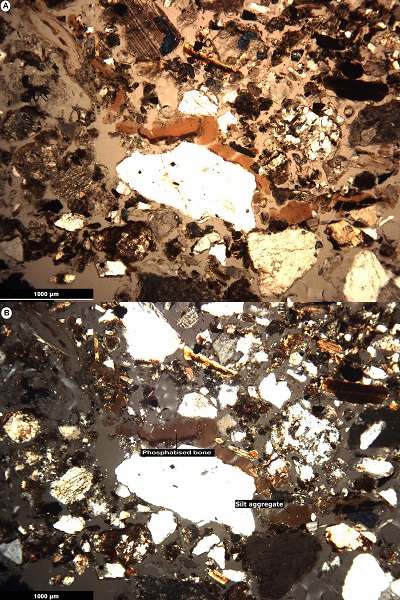 |
| Figure 11. Thin section photomicrographs from Trench 3, Profile East. A) microphotographs in plane polarized light (PPL) and B) crossed polarized light (XPL): The loosely aggregated sandy silt fabric with common very fine charcoal fragments, and the occasional degraded and phosphatised bone (pb) and silt aggregate (sa), Samaca H-8, sample 561 (lower) (frame widths = 4.5 mm; cross plane polarized). |
In sample 561, there are two fabric units. The lower fabric unit (1.5–11 cm) has a porosity between 20% to 30% with interconnected vughs and coarse to fine, sub–rounded to sub–angular quartz sand. It has a few (5%) aggregates of silt and micro–charcoal, as well as other sub–rounded organic components such as 20% of fine charcoal, bone fragments, both phosphatized and degraded. The uppermost fabric unit (0–1.5 cm) shows 30% to 40% porosity with an interconnected vughy and apedal, single grain structure. It contains mineral components as coarse to fine, sub–rounded to sub–angular quartz sand, and inclusions of fine charcoal (20%). This sequence is overlain by a 1 cm thick unit of fine to coarse sand.
In general, both samples 561 and 330 show a main fabric of fine to coarse quartz sand lenses over a vughy sand-silt aggregated fabric. In addition, both fabric units have fine to very fine inclusions of charcoal and few sub–rounded silt aggregates. The lensed components are indicative of probable episodes of river–borne sand deposition, with weakly structured yet bioturbated fabric units and fine anthropogenic components that are, at the same time, indicative of short–lived old land surfaces.
Up–profile, there was a c. 50 cm thick unit of homogeneous fine–medium quartz sands (i.e. context SUs 8206 in 8207) which was occasionally interrupted by thin, discontinuous lenses of brown organic sand. These are probably all reworked riverbed derived sands which have been transported and redeposited, mainly by wind and water action, ostensibly without buildings being present.
From the SU 8217, the base of the unit was sampled, which corresponds with thin section 573 (Figure 12). It was comprised of the two fabric units similar to those stated for SU 8220. The first corresponds to upper fabric unit (0–9/10 cm) with porosity similar to the previous sample, but with open interconnected vughs. The structure is apedal, single grain and heterogeneous. This unit presents the same mineral components as the two previous units (above). The inclusions are also the same, but with episodic inclusions of greater/lesser amounts of bone fragments and organic matter (see Figure 12). The lower fabric unit (9/10–12 cm) is the surface of contact with SU 8218 and shows similar characteristics in mineral components, porosity and structure; however, it varies in organic components. In this aspect, it exhibits phosphatized and degraded bone fragments (10%) and a few (5%) amorphous iron oxide replaced reddish orange (CPL), plant tissue fragments.
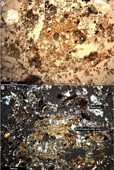 |
| Figure 12. Thin section photomicrographs from Trench 3, Profile East. A) microphotographs in plane polarized light (PPL) and B) crossed polarized light (XPL): Humic calcitic sand with common very fine charcoal (ch) and irregular zones of birefringent silty clay (sc), Samaca H8, sample 573 (frame widths = 4.5mm; cross polarized light). |
The bottom of this horizon, as in the point of contact with SU 8218 (see Figure 9), presents fine–medium quartz sand, occasional charcoal fragments and occasional discontinuous lenses of humic quartz sand. This context is probably related to wind or water deposition of sand, with occasional episodes of brief stability and organic matter accumulation, but with no buildings nor riverbed exposed.
Samples were also taken from stratigraphic units 8216 and 8217 above with two fabric units identified. The first corresponds to the upper fabric unit (0–3 cm), specifically to SU 8216, and shows low porosity (25%) and apedal, single grain but heterogeneous structure, and contains mainly a heterogeneous mix of very fine to medium sand. Furthermore, it shows inclusions in horizontal zones with weakly laminar amorphous iron impregnation, common micritic (silt–sized) calcium carbonate, few silt and silty clay fine sand size aggregates. These may be indicative of the episodic deposition of waterborne sands. SU 8217 was radiocarbon dated to cal AD 1054–1215 (Table 5). The second, lower fabric unit (3–11 cm), also has low porosity (<20%) and an apedal, single grain, heterogeneous structure, and contains mainly brown, micritic fine–medium, sub–rounded to sub–angular quartz sand. In addition, this fabric unit presents inclusions of fine to very fine charcoal, few rolled silt aggregates, few degraded bone fragments and common fine charcoal fragments.
These humic and calcitic aspects with the common anthropogenic inclusions suggest that the micritic quartz sand of stratigraphic units 8217 and 8216 is probably an aggrading old land surface. This was essentially a cumulative series of thin units of brown humic sand which included pottery, bone and charcoal fragments, as well as irregular zones and rolled aggregates of birefringent silty clay (Figure 12). The latter features are indicative of some illuviation of fines (silt and clay), possibly derived from overbank alluvial inputs incorporated into this surface through soil mixing processes (Kuhn et al., 2010). It is interrupted by less organic and more sandy or silty lenses or areas with higher frequencies of anthropogenic inclusions, especially fine charcoal and micritic ash and/or degraded and phosphatised bone fragments.
On top of units 8217 and 8216, there were c. 50 cm of alternating horizontal units of fine sand/silt with shell fragments interspersed with grey micritic ash and fine charcoal (i.e., SU 8206 and 8207). Covering this sediment was a thick conglomerate (c. 2 m thick) containing mud bricks, botanical remains, bones and much Late Intermediate Period pottery (Santana, 2021), together with the remains of collapsed adobe brick deposits.
4.2. GEOCHEMICAL AND GEOPHYSICAL ANALYSES
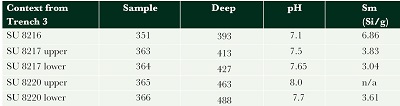
The pH values of Samaca H–8 samples range from 7.1 to 8 (Table 3 and Figure 13), which point to a neutral to moderately alkaline soil environment. The highest (alkaline) pH observed is in sample 365 (see Table 3), perhaps related to the physical characteristics of SU 8220, a compact and thick layer of sand with inclusions of bone and charcoal (see Figure 9).
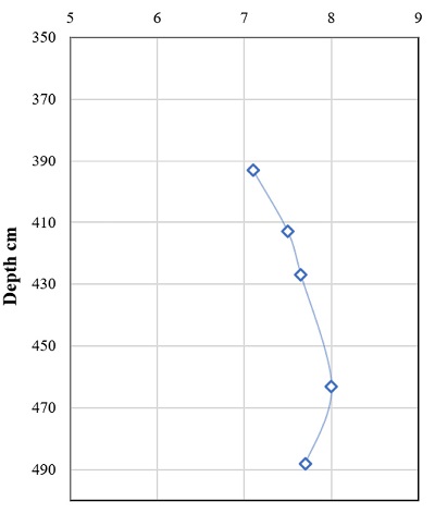 |
| Figure 13. pH values in Trench 3 (final section) of Samaca H–8. |
The magnetic susceptibility readings for these Samaca H–8 contexts are all relatively low (Table 3). These range from 6.86 to 3.61 Si/g, reflecting the low abundance of iron oxides (Figure 14). Sample 365 stands out as its magnetic behavior appears to be diamagnetic (s/n), although this may be noise due to the low values recorded. In contrast, sample 351, which corresponds to SU 8216, presents a relatively high value of magnetic susceptibility (see Table 3). This SU reflects that it is probably a surface with small in situ burning lenses, decomposed organic matter, low amounts of Ca (0.65%) and neutral pH values (7.1), in contrast to sample 365, which presents the highest pH value of 8.
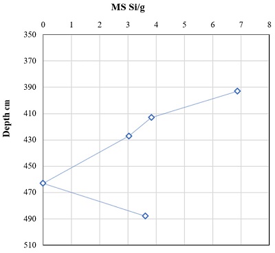 |
| Figure 14. Magnetic susceptibility levels in Trench 3 (final section) of Samaca H–8. |
| Table 3. Geochemical and geophysical analyses results. |
 |
The identification of multiple elements highlights the presence of very high phosphorus (P) values (Table 4), likely due to the presence of organic waste components. The same samples show low manganese (Mn) values. Likewise, the iron values are low, a characteristic that is reflected in the absence of reddening of the stratigraphic units sampled and in the thin sections observed (below), also in accordance with the pH and the values of magnetic susceptibility.
The low levels and availability of Zn is probably conditioned by the pH values (see Table 4). As the pH increases, the absorption capacity increases. Likewise, it would be conditioned by the sandy soils from the Trench 3, which, given their characteristics, contain low levels of organic matter, generating Zn deficiency in the soil.
| Table 4. Multiple elemental analysis results. |
 |
4.3. CHRONOLOGY
The chronology of the very beginning of the Late Intermediate Period when Samaca H–8 was presumably founded is poorly understood, not least because the calibration curve for these centuries is unfortunately and notoriously flat, so that relatively precise radiocarbon dates are transformed into wide possible ranges upon calibration (see Table 5 and Figure 15). However, calibrating and modeling the seven radiocarbon dates for Trench 3 as a single phase (as described) gives a boundary limit of AD 997–1194 (95% confidence limit) for the date of the foundation of Samaca H–8.
|
Table 5. Radiocarbon dating results of Samaca H–8, Trench 3. |
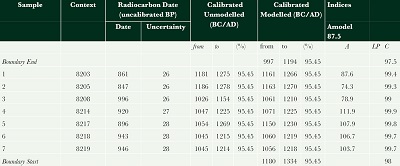 |
| Note: BP (Before Present); BC (before Christ); AD (after Christ). |
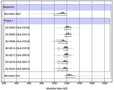 |
| Figure 15. Graphic of Radiocarbon dating results of Samaca H–8, Trench 3. OxCal v4.4.4. program. |
- Discussion
Much river incision and wind erosion have affected the landscape of the Samaca and Ullujaya basins (Beresford–Jones, 2014). Over the last two millennia it would appear that there has only been limited periods of floodplain stability during post–Late Nasca times (after AD 500). At that time the system completely changed to one dominated by erosion and truncation of floodplain surfaces and deposits, which initiated the destruction of the Nasca Period canal systems recorded by Beresford–Jones (2005). Earlier geoarchaeological work (Beresford–Jones et al., 2009b) suggested that the river began to become incised sometime after around AD 500, and that this may have been associated with ENSO event(s) of an even greater scale and severity than the 1997–1998 so–called ‘super–El Niño’ event (Bendix et al., 2002). More recently there has been substantial deflation and erosion as well as down–cutting of at least two–thirds or c. 5+ m of the valley fill sequence described above, much of this caused by the last super El Niño of 1997–8. This event led to the truncation and removal of much of the upper 1.2 m or so of the alluvial floodplain sequence of both pre and post–Nasca Period. Indeed, there has been similar destruction of much of the physical archaeological record; particularly, the complete destruction of the Late Intermediate settlement site of H–9 in the Samaca basin, as well as much earlier disturbance and partial removal of Nasca Period canal features in the Samaca–Ullujaya floodplain area (Beresford–Jones et al., 2009b; Beresford–Jones, 2014).
Geoarchaeological analysis of Trench 3 at the northern edge of Samaca H-8 has revealed a number of probable old land surfaces interspersed with episodes of sand deposition in a cumulative laminar ‘layer–cake’ stratigraphy over a total depth of c. 4.1 m. The latter are probably aeolian and alluvial deposits reworked by wind action from the exposed channel bed in the drier times of year. The former are really just stabilized surfaces of this same reworked sand, with some organic additions, weak structural development and illuvial silty clays, and the accumulation/inclusion of micritic ash, fine charcoal, amorphous iron replaced plant tissue fragments and/or bone fragments. These are derived from well–preserved rubbish deposits (by desiccation) and varied vestiges, such as archaeobotanical remains (cultivated plants, riparian forest, among others) (Chauca et al., 2017; Santana, 2019), pottery (Santana, 2021) and zooarchaeological remains (Arce et al., 2013) that reveal the evident human occupation in the adjacent H─8 settlement.
These types of formation and deposition could even be associated with some of the major dry periods that have occurred in the last few millennia. These are also suggested by some researchers (Eitel et al., 2005; Mächtle et al., 2010; Mächtle, 2017), which, in particular, point to periods of greater aeolian transport suggested for the Ica Valley c. 2800–2600 and 1500–700 years ago (Londoño et al., 2012).
Likewise, the low values of magnetic susceptibility reflect the absence of continuous and considerable oxidation processes, for example, by wetting and drying. However, the increase in the value in SU 8216 suggests a probable improvement in the values related to processes of burning cultural rubbish and organic decomposition, which evidence anthropogenic processes. This is related to the vestiges’ high density, from which lenses of ash and coal stand out as a consequence of in situ burning (see Figure 9 and 10). All of it as a result of human activity both in the stratigraphic unit aforementioned (8216), and others located in superior sections of this north profile (Trench 3). Considerably higher values of magnetic susceptibility in the floodplain elsewhere in the Samaca and Ullujaya basins during the Early Intermediate Period (AD 110–620), contrast strongly with those presented here for Samaca H–8. Beresford–Jones et al. (2009b) and Santana et al. (2021) suggest that these enhanced values may be associated with seasonal floods and subsequent transpiration due to evaporation, which will consequently generate oxidation processes. These processes would be typical of erratic–flowing dryland river systems like the Rio Ica and, of course, periodic El Niño events, but also to relatively favorable pedogenetic processes and moderately stable conditions for the formation of these soils. This would suggest a relatively stable environment prior to the Late Nasca Period (AD 440–640; Unkel et al., 2012) and the Middle Horizon (AD 663–1118; Cadwallader et al., 2015). The setting would have been different during the transition of Middle Horizon and the beginning of Late Intermediate Period (transition dated here to cal AD 997–1194 as the boundary limit of the seven radiocarbon dates modeled as a single contiguous phase) (see Figure 15 and Table 5). This is due to the fact that values presented for Samaca H-8 suggest the existence of unfavorable pedogenetic processes, which could also suggest the existence of short–life surfaces prone to almost immediate degradation, especially due to wind action (normally with blown sand). This is seen in distinct stratigraphic units located in the deepest sections of Trench 3, which present thick layers of sand (see Figure 8 and 10, Arce et al., 2013; Chauca et al., 2017).
Soil reaction of the Samaca H–8 contexts range from neutral to moderately alkaline, which in turn influences the low amounts of some elements such as Zn and Fe. Although the amounts of phosphorus in this type of alkaline soils are often low due to the characteristics of the surface (rich in nutrients, calcium carbonate fixation, among others) and the activities that take place in them, in this case, the samples show high values. However, the low amounts of other elements suggest the presence of poorly soluble mineral components in these soils, as confirmed by the micromorphological observations that accounts for poorly developed soils mainly presenting abundant coarse to fine sand grains.
Finally, geoarchaeological analyzes point to the transformation of the environment affected by a gradual process of aridification, with long dry periods and considerable wind activity, prevailing, at least, from the end of the Middle Horizon (c. AD 900) until the first occupation of Samaca H-8 around AD 1000 (see Table 5). Micromorphological analyzes in the Samaca H-8 sequence reveal that the levels prior to its occupation are interrupted by c. 20–60 cm thick layers of fine–medium sand. These appear to be reworked, transported and re–deposited channel bed deposits, and could indicate conditions of greater aridity in the valley system around the end of 1st millennium AD.
These dated observations provide complementary and corroborative evidence of drier and stronger erosive effects in the system, which could be associated with the onset of more severe El Niño conditions over the past 1000–2000 years (Beresford–Jones et al., 2009b; Beresford–Jones, 2014; Santana et al., 2021). However, they are also likely linked to the exposure of the landscape due to the deforestation and destruction of the riparian woodland mainly during the Late Nasca (AD 440–640; see Unkel et al., 2012) and subsequent Middle Horizon periods (Beresford–Jones et al., 2009a; Beresford–Jones, 2014). Likewise, geochemical and physical analyzes reflect the existence of surfaces affected by dynamics of high degradation or environmental and climatic instability.
- Conclusions
The ecological relationships between environmental features and anthropogenic actions have become a fundamental line of research to understand the long and complex histories of different territories.
The above sections have tackled this subject using a case study from the past, an ancient community of the southern coast of Peru recorded by archaeologists as Samaca H–8. The geoarchaeological analyses carried out on the deep foundational contexts of Samaca H-8 site suggest degraded and unstable surfaces, perhaps due to a dynamic of severe landscape and environmental change prevailing in the Samaca basin towards the end of the Middle Horizon just before the site was founded at around AD 1000 at the start of the Late Intermediate Period. Based on the evidence provided above, this situation is reflected in poorly developed soils observed both in the field, and in thin sections and low magnetic susceptibility signals. Likewise, pH ranges indicate the existence of soils with a tendency to form calcretes and calcium carbonates as part of a long period of drying under arid conditions, alongside low amounts of elements such as Fe and Mn.
The radiocarbon data presented demonstrates that the construction and first occupation of Samaca H-8 (or at least its westernmost part) took place during the transition from the end of the Middle Horizon to the Late Intermediate Period.
This time was, it seems, marked by environmental dynamics and drastic landscape change towards more arid conditions, and with the recurrent deposition of wind–blown materials, perhaps due to a lack of protection offered by a riparian dry forest cover. Thus, this paper shows that whereas those changes in the landscape and environment of the basins of the Lower Ica Valley took place in times prior to the Late Intermediate Period and were caused by natural processes, they were probably triggered by anthropogenic actions such as the removal of riparian vegetation.
Contributions of authors
(1) Conceptualization: L.S.Q., C.A.I.F. and D.G.B-J; (2) Analysis or data acquisition: L.S.Q., C.A.I.F. and D.G.B-J; (3) Methodological/technical development: C.A.I.F. and L.S.Q; (4) Writing of the original manuscript: L.S.Q. and C.R.C.H; (5) Writing of the corrected and edited manuscript: L.S.Q., C.A.I.F., D.G.B-J; (6) Interpretation: L.S.Q., C.A.I.F., D.G.B-J. and C.R.C.H; (7) Financing: institutional.
Financing
(1) One River Project-University of Cambridge; (2) Escuela Libre Puerto Huamaní-Alberto Benavides Ganoza.
Acknowledgements
We would like to thank our hosts, benefactors and collaborators in Peru, particularly Alberto Benavides, Susana Arce and the people of Samaca for facilitating fieldwork; all participants of the Proyecto de Investigación Arqueológica Samaca and Jorge Rodríguez. We would also like to thank Dr. Tonko Rajkovača of the McBurney Geoarchaeology Laboratory, Department of Archaeology, University of Cambridge, for making the thin sections, and the ALS Global Laboratory, Seville, Spain, for the ICP-AES multi-element results.
Conflicts of interest
No potential conflict of interest was reported by the authors.
References
Arce, S., Pullen, A.G, Huaman, J, O., Chauca, G.E., Beresford-Jones, D.G., 2013, Informe de los trabajos realizados en La Yerba II, Boca del Río Ica y Samaca H-8 durante la temporada 2013: Perú, Ministerio de Cultura del Perú, 96p.
Bachir Bacha, A., Llanos, O., 2013, ¿Hacia un urbanismo Paracas en Animas Altas/Animas Bajas (Valle de Ica)?:Boletín de Arqueología PUCP, 17, 169-204.
Bendix, A., Bendix, J., Gammerier, S., Reudenbach, C., Weise, S., 2002, The El Niño 1997/98 as seen from space – rainfall retrieval and investigation of rainfall dynamics with GOES-8 and TRMM data, in Proceedings of the 2002 Eumestat Meteorological Satellite Conference, Dublin, Ireland, 647-652.
Benito-Calvo, A., Campaña, L. I., Karampaglidis, T., 2015, Conceptos básicos y métodos en geoarqueología: geomorfología, estratigrafía y sedimentología: Treballs D’arqueologia, 20, 41-54.
Beresford-Jones, D., 2005, Pre-Hispanic Prosopis-human relationships on the south coast of Peru: Riparian forests in the context of environmental and cultural trajectories of the Lower Ica Valley: United Kingdom, University of Cambridge, Ph.D. Dissertation, 520p.
Beresford-Jones, D., 2014, Los Bosques desaparecidos de la antigua Nasca: estudio de un caso de colapso ecológico y cultural: Lima, Antares, 300p.
Beresford-Jones, D., Alarcón, C., Arce, S., Chepstow-Lusty, A., Whaley, O., Sturt, F., Gorriti, M., Portocarrero, O., Cadwallader, L., 2009a, Ocupación y subsistencia del Horizonte Temprano en el contexto de cambios ecológicos de largo plazo en las cuencas de Samaca y Ullujaya, valle bajo de Ica: Boletín de Arqueología PUCP, 13, 237-257.
Beresford-Jones, D., Lewis, H., Boreham, S., 2009b, Linking cultural and environmental change in Peruvian prehistory: Geomorphological survey of the Samaca Basin, Lower Ica Valley, Peru: Catena, 78(3), 234-249. https://doi.org/10.1016/j.catena.2008.12.010
Beresford-Jones, D., Pullen, A. G., Whaley, O. Q., Moat, J., Chauca, G., Cadwallader, L., Arce, S., Orellana, A., Alarcón, C., Gorriti, M., Maita, P.K., Sturt, F., Dupeyron, A., Huaman, O., Lane, K.J., French, C., 2015, Re-evaluating the resource potential of lomas fog oasis environments for Preceramic hunter-gatherers under past ENSO modes on the south coast of Peru: Quaternary Science Reviews, 129, 196-215. https://doi.org/10.1016/j.quascirev.2015.10.025
Beresford-Jones, D., Pullen, A., Chauca, G., Cadwallader, L., García, M., Salvatierra, I., Whaley, O., French, C., 2018, Refining the Maritime Foundations of Andean Civilization: How Plant Fiber Technology Drove Social Complexity During the Preceramic Period: Journal of Archaeological Method and Theory, 25(2), 393-425. https://doi.org/10.1007/s10816-017-9341-3
Bronk, R. C., 2009, Bayesian analysis of radiocarbon dates: Radiocarbon, 51, 337-360. https://doi.org/10.1017/S0033822200033865
Butzer, K., 1989, Arqueología, una ecología del hombre: método y teoría para un enfoque contextual: Barcelona, Bellaterra, 418p.
Butzer, K., 2008, Challenges for a cross-disciplinary geoarchaeology: The intersection between environmental history and geomorphology: Geomorphology, 101(1-2), 402-411. https://doi.org/10.1016/j.geomorph.2008.07.007
Butzer, K. 2011, Geoarchaeology, climate change, sustainability: A Mediterranean perspective, in Brown, A., Basell, L., Butzer, K. (eds.), Geoarchaeology, climate change, and sustainability: Texas, USA, Geological Society of America, 1-14. https://doi.org/10.1130/2011.2476
Cadwallader, L., 2013, Investigating 1500 years of dietary change in the Lower Ica Valley, Peru using an isotopic approach: United Kingdom, University of Cambridge, Ph.D dissertation, 359p. https://doi.org/10.17863/CAM.15978
Cadwallader, L., Arce, S., O’Connell, T., Pullen, A., Beresford-Jones, D., 2015, Dating the dead: new radiocarbon dates from the lower Ica valley, south coast Peru: Radiocarbon, 57, (5), 765–773. https://doi.org/10.2458/azu_rc.57.18343
Cadwallader, L., Beresford-Jones, D., Sturt, F., Pullen, A., Arce, S., 2018, Doubts about How the Middle Horizon Collapsed (ca. A.D. 1000) and other insights from the looted cemeteries of the Lower Ica Valley, South Coast of Peru: Journal of Field Archaeology, 43(4), 316-33. https://doi.org/10.1080/00934690.2018.1464306
Carré, M., Sachs, J.P., Purca, S., Schauer, A.J., Braconnot, P., Falcon, R.A., Julien, M., Lavallee, D., 2014, Holocene history of ENSO variance and asymmetry in the eastern tropical Pacific: Science, 345, 1045-1048. https://doi.org/10.1126/science.1252220
Chauca, G., Morriset, S., Beresfor-Jones, D., 2017, Proyecto de Investigación Arqueológica Samaca Temporada 2017: Perú, Ministerio de Cultura del Perú.
Clark, A., 1996, Seeing beneath the Soil: prospecting methods in archaeology, 2nd ed.: London: Routledge, 196p.
Contreras, D.A., 2010, Landscape and environment: insights from the prehispanic central Andes: Journal of Archaeological Research, 18, 241-288. https://doi.org/10.1007/s10814-010-9038-6
Cook, A., 1994, Informe final de las investigaciones de reconocimiento arqueológico en la parte baja del valle de Ica (1988-1990), vol. 1: Perú, Ministerio de Cultura del Perú.
Courty, M. A., Goldberg, P., Macphail, R., 1989, Soils and micromorphology in archaeology: Cambridge, Cambridge University Press, 334p.
Del Águila, C., 2010, La vigencia de un método en arqueología: Sobre la propuesta de periodificación cultural del área andina de John H. Rowe: Arqueología y Sociedad, 21, 109-118. https://doi.org/10.15381/arqueolsoc.2010n21.e12280
DeLeonardis, L., 1997, Paracas settlement in Callango, lower Ica Valley, 1st millennium B.C., Peru: Washington D.C., The Catholic University of America, Ph.D Dissertation, 713p.
DeLeonardis, L., 2005, Early Paracas cultural contexts: New evidence from Callango: Andean Past, 7, 27-55.
Eitel, B., Hecht, S., Machtle, B., Schkraft, G., Kadereit, A., Wagner, G., Kromer, B., Unkel, I., Reindel, M., 2005, Geoarchaeological evidence from desert loess in the Nazca-Palpa region, south Peru: palaeoenvironmental changes and their impact on pre-Columbian cultures: Archaeometry, 47(1), 137-158. https://doi.org/10.1111/j.1475-4754.2005.00193.x
Eitel, B., Mächtle, B., 2009, Man and environment in the Eastern Atacama Desert (Southern Peru): Holocene climate changes and their impact on Pre-Columbian cultures, in Reindel, M., Wagner, G., (eds.), New technologies for archaeology: multidisciplinary investigations in Palpa and Nasca, Peru: Berlin, Springer,17-23. https://doi.org/10.1007/978-3-540-87438-6_2
Engel, F., 1991, Un desierto en tiempos prehispánicos: Río Pisco, Paracas, Río Ica: Perú, Didi de Arteta, 167p.
Engel, F., 1981, Prehistoric Andean Ecology: Man, settlement and environment in the Andes in the Andes. The Deep South: New York, Humanities Press, 155p.
French, C., 2003, Geoarchaeology in action: Studies in soil micromorphology and landscape evolution: London, Routledge, 320p. https://doi.org/10.4324/9780203987148
French, C., 2015, A handbook of geoarchaeological approaches for investigating landscapes and settlement sites: Oxford, Oxbow Books, 144p.
Gilbert, A., Goldberg, P., Holliday, V., Mandel, R., Sternberg, R., 2017, Preface, in Gilbert, A. (ed.), Encyclopedia of geoarchaeology: Netherlands, Springer, 26-27p. https://doi.org/10.1007/978-1-4020-4409-0
Goldberg, P., Macphail, R., 2006, Practical and theoretical geoarchaeology: Oxford, UK, Blackwell Publishing, 463p. https://doi.org/10.1002/9781118688182
Haburaj, V., 2016, Natur-Räumliche Analyse archäologischer Stätten im Rio-Ica-Einzugsgebiet, Perú. Berlin, Freie Universität Berlin, Masters Dissertation.
Hesse, R., Baade, J., 2009, Irrigation agriculture and the sedimentary record in the Palpa Valley, southern Peru: Catena, 77(2), 119-129. https://doi.org/10.1016/j.catena.2008.09.003
Hogg, A. G., Heaton, T., Hua, Q.,Palmer, J., Turney, C. S. M., Southon, J., Bayliss, A., Blackwell, P., Boswijk, G., Bronk Ramsey, C., Petchey, F., Reimer, P. J., Reimer, R. W., Wacker, L., 2020, SHCal20 Southern Hemisphere calibration, 0-55,000 years cal BP: Radiocarbon, 62, 759-778. https://doi.org/10.1017/rdc.2020.59
Holliday, V. T., 2004, Soils in Archaeological Research: New York, Oxford University Press, 464p.
Kuhn, P., J. Aguilar, Miedema, R., 2010,Textural features and related horizons, in Stoops, G., Marcelino, V., Mees, F.,(eds.), Interpretation of micromorphological features of soils and regoliths: Amsterdam: Elsevier, 217-250.
Londoño, A.C., Forman, S.L., Eichler, T., Pierson, J., 2012, Episodic eolian deposition in the past ca. 50,000 years in the Alto Ilo dune field, Southern Peru: Palaeogeography, Palaeoclimatology, Palaeoecology, 346-347, 12-24. https://doi.org/10.1016/j.palaeo.2012.05.008
Mächtle, B., Unkel, I., Eitel, B., Kromer, B., Schiegl, S., 2010, Molluscs as evidence for a late Pleistocene and early Holocene humid period in the southern coastal desert of Peru (14.5°S): Quaternary Research, 73(1), 39–47. https://doi.org/10.1016/j.yqres.2009.05.007
Machtle, B., Eitel, B., 2013, Fragile landscapes, fragile civilizations – how climate determined societies in the pre-Columbian south Peruvian Andes: Catena, 103, 62-73. https://doi.org/10.1016/j.catena.2012.01.012
Mächtle, B., Schittek, K., Reindel, M., Eitel, B., 2017, Cambios paleoclimáticos y su influencia sobre el desarrollo cultural en el sur del área central andina: Revista de Arqueología Americana, 35, 33-50. https://doi.org/10.35424/rearam352017%25f
Massey, S., 1991, Social and political leadership in the lower Ica Valley: Ocucaje phases 8 and 9, In Paul, A., (ed.), Paracas art and architecture: Object and context in south coastal Peru: Iowa City: University of Iowa Press, 349-416.
Menzel, D., 1964, Style and time in the Middle Horizon: Ñawpa Pacha: Journal of Andean Archaeology, 2, 1-105. https://doi.org/10.1179/naw.1964.2.1.001
Menzel, D., 1971, Estudios arqueológicos en los valles de Ica, Pisco, Chincha y Cañete: Arqueología y Sociedad, 6, 9-100. https://doi.org/10.15381/arqueolsoc.1971n6.e12774
Menzel, D., 1976, Pottery style and society in ancient Peru: Art as a mirror of history in the Ica Valley: Berkeley, University of California Press, 1350-1570.
Menzel, D., Rowe, J., Dawson, L., 1964, The Paracas pottery of Ica: A study in style and time: Berkeley, American Archaeology and Ethnology, 399p.
Moseley, M., Feldman, R., 1982, Vivir con crisis: percepción humana de proceso y tiempo: Revista del Museo Nacional, 46, 267–287
Murphy, C.P., 1986, Thin section preparation of soils and sediments: Berkhamsted, AB Academic, 149p.
Nials, F., Dees, E., Moseley, M., Pozorski, S. G., Pozorski, T., Feldman, R., 1979, El Niño: The Catastrophic Flooding of Coastal Peru. Field Museum of Natural History Bulletin, 50(4), 4–14.
Oonk, S., Slomp, C.P., Huisman, D.J., 2009, Geochemistry as an aid to archaeological prospection and site interpretation: Current issues and research directions: Archaeological Prospection, 16, 35-51. https://doi.org/10.1002/arp.344
Ortlieb, L., Vargas, G., 2003, Debris-flow deposits and El Niño impacts, in Haas, J., Dillon, M.O. (eds.), El Niño in Peru: Biology and culture over 10,000 years: Chicago, Field Museum of Natural History, 24-51.
Ramón, G., 2013, La escuela de Berkeley y los Andes precoloniales: génesis del método (1944-1965), in Tantaleán, H., Astuhuamán, C., (eds.), Historia de la arqueología en el Perú del siglo XX: Lima, Instituto de Estudios Andinos e Institute of Andean Research, 237-252.
Ramón, G., 2010, La periodificación como acción narrativa del pasado pre-colonial (un ejemplo andino): Revista de Investigaciones del Centro de Estudiantes de Arqueología, 7, 102-127.
Ramón, G., 2005, Periodificación en arqueología peruana: Genealogía y aporía: Boletín del Instituto Francés de Estudios Andinos (Lima), 34 (1), 5-33. https://doi.org/10.4000/bifea.5567
Ramón, G., 1994, Periodificación en arqueología peruana: Revista Investigaciones CEAR, 4, 42-70.
Rossel, C. A., 1977, Arqueología sur del Perú: Áreas: Valles de Ica y la Hoya de Río Grande de Naska: Lima, Ed. Universo, 368p.
Rowe, J., 1962, Stages and periods in archaeological interpretation: South western Journal of Anthropology, 18(1), 40-54. https://doi.org/10.1086/soutjanth.18.1.3629122
Rowe, J., 1960, Tiempo, estilo y proceso cultural en la arqueología Peruana: Berkeley, Institute of Andean Studies, 15p.
Sandweiss, D. H., Maasch, K. A., Burger, R. L., Richardson, J. B., Rollins, H. B., Clement, A., 2001, Variation in Holocene El Niño frequencies: Climate records and cultural consequences in ancient Peru: Geology, 29(7), 603-606. https://doi.org/10.1130/0091-7613(2001)029<0603:viheno>2.0.co;2
Sandweiss, D. H., Kelley, A. R., 2012, Archaeological contributions to climate change research: The archaeological record as a paleoclimatic and paleoenvironmental archive: Annual Review of Anthropology, 41, (1), 371-391. https://doi.org/10.1146/annurev-anthro-092611-145941
Sandweiss, D. H., Andrus, C. F. T., Kelley, A. R., Maasch, K. A., Reitz, E. J., Roscoe, P. B., 2020, Archaeological climate proxies and the complexities of reconstructing Holocene El Niño in coastal Peru: Proceedings of the National Academy of Sciences, 117(15), 8271-8279. https://doi.org/10.1073/pnas.1912242117
Santana, L., French, C., Beresfod-Jones, D., Arce, S., Chauca, G., 2021, Caracterización paleoambiental de las cuencas de Samaca y Ullujaya, valle bajo de Ica: aportes a partir del estudio geoarqueológico, en VI Congreso Nacional de Arqueología: Perú, Ministerio de Cultura,119-129.
Santana, L., 2021, La secuencia cultural de Samaca, valle bajo de Ica: aportes a partir del análisis del material cerámico: Perú, Universidad Nacional Mayor de San Marcos, Bachelors Dissertation, 279p.
SENAMHI, 2014, El fenómeno El Niño en el Perú: Perú, Ministerio del Ambiente, Servicio Nacional de Meteorología e Hidrología.
SENAMHI, 2021, Climas del Perú: Mapa de clasificación climática nacional: Perú, Ministerio del Ambiente, Servicio Nacional de Meteorología e Hidrología.
Soßna, V., 2015, Climate and settlement in Southern Peru: The Northern Río Grande de Nasca drainage between 1500 BCE and 1532 CE: Wiesbaden, Reichert Verlag, 320p.
Tantaleán, H., 2016, Una historia de la arqueología peruana: Lima, Instituto de Estudios Peruanos y Universidad San Francisco de Quito, 308p.
Uceda, S., Gayoso, H., Castillo, F., Rengifo, C., 2021, Climate and social changes: Reviewing the equation with data from the Huacas de Moche archaeological complex, Peru: Latin American Antiquity, 32(4),705-722. https://doi.org/10.1017/laq.2021.35
Unkel, I., Kadereit, A., Mächtle, B., Eitel, B., Kromer, B., Wagner, G., Wacker, L., 2007, Dating methods and geomorphic evidence of palaeoenvironmental changes at the eastern margin of the South Peruvian coastal desert (14°30′ S) before and during the Little Ice Age: Quaternary International, 175(1), 3-28. https://doi.org/10.1016/j.quaint.2007.03.006
Unkel, I., Kromer, B., 2009, The Clock in the corn cob: On the development of a chronology of the Paracas and Nasca period based on radiocarbon dating, in Reindel, M., Wagner, G.A., (eds.), New technologies for archaeology: multidisciplinary investigations in Palpa and Nasca, Peru: Berlin: Springer-Verlag, 231-244. https://doi.org/10.1007/978-3-540-87438-6_14
Unkel, I., Reindel, M., Gorbahn, H., Isla, C. J., Kromer, B., Sossna, V., 2012, A comprehensive numerical chronology for the pre-Columbian cultures of the Palpa valleys, south coast of Peru: Journal of Archaeological Science, 39(7), 2294-2303. https://doi.org/10.1016/j.jas.2012.02.021
Wilson, C., Davidson, D.A., Cresser, M., 2008, Multi-element soil analysis: an assessment of its potential as an aid to archaeological interpretation: Journal of Archaeological Science, 35(2), 412-424. https://doi.org/10.1016/j.jas.2007.04.006
Willey, G. R., 1971, An introduction to American archaeology, Vol. 2: Englewood Cliffs, Prentice-Hall, 544p.
Peer Reviewing under the responsibility of Universidad Nacional Autónoma de México.
This is an open access article under the CC BY-NC-SA license(https://creativecommons.org/licenses/by-nc-sa/4.0/)