
|
Boletín de la Sociedad Geológica Mexicana Volumen 74, núm. 3, A100422, 2022 http://dx.doi.org/10.18268/BSGM2022v74n3a100422
|
 |
Use of sediments and soils (paleosols) in construction fills of the La Joya archaeological site, Veracruz, Mexico: micromorphological evidence
Uso de sedimentos y suelos (paleosuelos) en rellenos de construcción del sitio arqueológico La Joya, Veracruz, México: evidencias micromorfológicas
Thania A. García-Zeferino1, Annick Daneels2, Jaime Díaz-Ortega3, Elizabeth Solleiro-Rebolledo3,*
1 Posgrado en Ciencias de la Tierra, Instituto de Geología, Universidad Nacional Autónoma de México, 04510, CDMX, Mexico.
2 Instituto de Investigaciones Antropológicas, Universidad Nacional Autónoma de México, 04510, CDMX, Mexico.
3 Instituto de Geología, Universidad Nacional Autónoma de México, 04510, CDMX, Mexico.
* Corresponding author: (E. Solleiro-Rebolledo) This email address is being protected from spambots. You need JavaScript enabled to view it.
How to cite this article:
García-Zeferino, T.A., Daneels, A., Díaz-Ortega, J., Solleiro-Rebolledo, E., 2022, Use of sediments and soils (paleosols) in construction fills of the La Joya archaeological site, Veracruz, Mexico: micromorphological evidence: Boletín de la Sociedad Geológica Mexicana, 74 (3), A100422. http://dx.doi.org/10.18268/BSGM2022v74n3a100422
Manuscript received: November 30, 2021; Corrected manuscript received: February 22, 2022; Manuscript accepted: April 5, 2022.
ABSTRACT
In this paper, we study the materials used for the construction of earthen structure in the La Joya archaeological site, on the Gulf of Mexico coast, built on top of a paleodune, from the Late Preclassic (400 BC) to the Classic period (AD 100-1000). The first constructions arise around 100 BC, on a paleodune top rising slightly above the surrounding alluvial terraces of the Jamapa river; then it grows into a 15-ha monumental compound. The total construction volume reaches 250,000 m3, all made of earth, surrounded by large artificial water pounds (reservoirs). To understand the kind of components found in the structures and their provenance, we compare the micromorphological features of the materials from the earthen constructions with the sediments and paleosols located in the surrounding areas. Samples were taken from the fills of three first building stages, as well as from a natural soil profile and the natural paleosol horizons found beneath the structures. Micromorphological features found in fills permit to establish the correlation between them and their parent material. The fills from the first stage of construction have fragments of a Btb horizon, mixed with an A horizon, compacted and crushed, in which abundant artifacts are identified. However, these artifacts were not intentionally incorporated to the fills, but had been accumulated on the pre-occupation A horizon as residential and agriculture trash. Particular attention was paid to a gley material occurring in the third building stage, that was believed to come from the sediments accumulated in the original borrow pits transformed into water reservoirs, enclosing the main architectural compound. These reservoir fills share properties of the natural sediments and paleosols but transformed by the waterlogging conditions. In consequence, these materials are interpreted as a case of anthropogenic pedogenesis, where the gley micromorphology indicates waterlogging conditions, but in artificially made reservoirs, as they do not have dark organic sediments that would result of the vegetation typical of a natural pond in a humid tropical environment.
Keywords: Gulf of Mexico coast, earthen architecture, gley material, paleodune sediments, water reservoir.
RESUMEN
En este trabajo, se estudiaron los materiales usados para la construcción de una estructura de tierra en el sitio arqueológico de La Joya, en la costa del Golfo de México, construida del Preclásico tardío (400 AC) al periodo Clásico (100-1000 DC). Las primeras construcciones se levantaron alrededor del 100 AC, sobre la cima de una paleoduna, ligeramente arriba de las terrazas aluviales circundantes del río Jamapa; entonces, el sitio crece hasta adquirir un complejo monumental de 15 ha. La construcción total alcanza un volumen de 250,000 m3, toda hecha de tierra, rodeada de grandes pozas artificiales de agua (aljibes). Para entender el tipo de componentes encontrados en las estructuras y su procedencia, se comparó la micromorfología de los materiales de las construcciones de tierra con los sedimentos y paleosuelos localizados en los alrededores. Se tomaron muestras de rellenos de tres etapas constructivas, así como de un perfil natural de suelos y de los horizontes de paleosuelos encontrados debajo de las estructuras. Las características micromorfológicas encontradas en los rellenos permiten establecer la correlación entre ellos. Los rellenos de la primera etapa constructiva tienen fragmentos de un horizonte Btb, mezclado con un horizonte A, compactado y molido, en donde se identifican abundantes artefactos. Sin embargo, estos artefactos no se incorporaron intencionalmente a los rellenos, sino que habían sido acumulados en el horizonte A pre-ocupación, como basura residencial y agrícola. Particular atención fue puesta al material gléyco presente en los rellenos de la tercera etapa constructiva que se piensa vienen de los sedimentos acumulados en depresiones, transformadas en reservorios de agua, limitando el complejo arquitectónico principal. Estos rellenos del reservorio comparten propiedades con los sedimentos naturales y los paleosuelos transformados por las condiciones de saturación de agua. En consecuencia, estos materiales son intempretados como un caso de pedogénesis antropogénica, en donde la micromorfología del gley indica condiciones de saturación de agua, pero a causa de un cuerpo de agua artificial, ya que no muestran sedimentos orgánicos oscuros que resultarían de la vegetación típica de un estanque, bajo un ambiente tropical húmedo.
Palabras clave: costa del Golfo de México, arquitectura de tierra, material gléyco, sedimentos de paleoduna, aljibe.
- Introduction
The identification of the materials used in earthen structures (fills) has attracted the attention of scholars to provide information about their natural sources, their natural and anthropic modifications during the different stages of construction (Courty et al., 1989) as well as about the paleoenvironment and the human impact to the landscape (Butzer, 1982). Different methodologies have been applied in such identification as the physicochemical characterization of soils, sediments, and fills (Liberotti and Daneels, 2012; Itkin et al., 2018; Bezada et al., 2020); geochemistry of soils and sediments to detect activity areas (Sulas et al., 2019; Williams et al., 2021), to reconstruct historic soil contamination (Wilson et al., 2005), or to trace anthropogenic activity (Da Costa and Kern, 1999). In recent years, micromorphological studies have demonstrated their value to discriminate between natural factors and human influence on the materials (Courty et al., 1989; Macphail and Goldberg, 2017); the cultural influence on the sediments and soils (Fisher and Macphail, 1985; Courty et al., 1989; Courty, 1991; Devos et al., 2013); the sources from which the earthen structures were constructed (Laporte et al., 2015); the techniques applied for the construction (Khokhlova and Nagler, 2020).
In Mexico, first micromorphological works related to archaeological problems appear more recently, and particularly applied to cultivated soils (McClung et al., 2004) and for paleoenvironmental reconstruction (Solleiro-Rebolledo et al., 2006). Though scarce, the application of micromorphology to study pre-Hispanic architecture has contributed to the understanding and identification of the kind of materials used for the construction. Nevertheless, most of these studies have been dedicated to stone-faced structures as in Teotihuacan (Barba et al., 2009; Blancas et al., 2019), or in the Mixteca Alta, Oaxaca (Finsten et al., 1996), and relate to stuccos (Straulino et al., 2013). The application of micromorphology to the earthen structures is limited. However, there are some works on adobes of the Cholula Pyramid (Pérez et al., 2016) and adobes from Sabina Grande and Zethé archeological sites (Gama-Castro et al., 2012). The fills of the Moon pyramid were also studied by micromorphology, finding the use of natural and agricultural soils to form the core of the ancient buildings (Rivera-Uria et al., 2007). According to Barba (1995), the amount of extracted material from the surrounding soils accounts for 5 km2.
The large-scale earthworks at La Joya located in the coastal lowlands in the humid tropical environment of the Gulf of Mexico started 2000 years ago (Daneels and Guerrero-Baca, 2011). The archaeological studies reveal that during the first stages of construction, the superficial soil horizons were used, mixed with abundant human refuse, result of a 1000-year occupation of the site prior to monumental construction (Daneels and Guerrero-Baca, 2011). The following stages appear to be made from sediments dug from borrow pits cutting through alluvial terraces and paleodunes. Archaeological evidence suggests these reservoirs were usually kept flooded by a hydraulic system capturing the nearby river flow, but that they were occasionally drained and dried to extract gleyic sediment to use as construction fill. Particular attention is given to the gleys developed at the bottom of artificial water reservoirs and those present in the third building stage of the monumental architectural compound of the site of La Joya. The aim of this work is to corroborate the archaeological interpretation using micromorphological analyses of samples from the fills of structures of different age, from the reservoir, from the natural paleosols buried below the structures and from the paleodune sediments.
- Materials and methods
2.1. GEOGRAPHIC AND GEOLOGICAL CONTEXT
The site is on the coastal floodplain of the Gulf of Mexico, central Veracruz, in a subhumid tropical climate Aw2(w), with summer rains averaging 1500 mm per year (García, 1970). It is located at 4.5 m asl (above sea level), 19.07° North latitude and 96.15° West longitude (UTM 14Q 799967.2 E, 2110621.6 N), 6 km inland from the coastline and close to the confluence of the Jamapa and Cotaxtla rivers (Figure 1a). These two rivers originate about 100 km inland, to the West, on the flanks of the predominately andesitic Pico de Orizaba volcano, part of the Trans-Mexican Volcanic Belt with important Late Pleistocene and Holocene activity (Carrasco-Núñez, 2000). Therefore, most of the coastal plains are formed by erosion of andesitic volcanic rocks, with feldspars, plagioclases and amphiboles predominating (Silva-Mora, 2009; Armstrong-Altrin et al., 2015). On the other hand, the dune systems along the coast may have up to 50% quartz, probably brought by marine currents from non-volcanic sectors of the Gulf Coast (Carranza-Edwards and Rosales-Hoz, 1995; Kasper- Zubillaga, 1999).
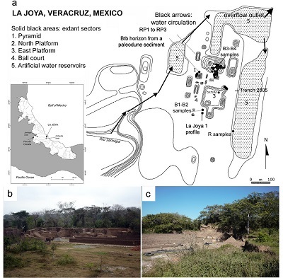 |
| Figure 1. a) Sketch map of La Joya, with the monumental compound (based on the 1937 sketch) surrounded by reservoirs (mapped in 2004). The level curves are drawn every 2 m. Solid black areas indicate remained sectors in 2008. Arrows indicate the water circulation pattern of the hydraulic system. Solid pentagons indicate the location of the sampling areas: natural soil in La Joya profile 1; Btb horizon developed on a paleodune sediment; the reservoir (samples R), and the fills (RP and B samples); b) photography of the site with a view of the North Platform; c) detail of destruction of the site by the extraction of the earth to make bricks. |
2.2. ARCHAEOLOGICAL CHARACTERISTICS OF THE LA JOYA SITE
La Joya is a monumental earthen architecture site in the central part of the Gulf Coast area of Mesoamerica (Figure 1b), of the regional culture known as Remojadas, spanning the Late Preclassic (400 BC) to the Classic period (AD 100-1000) (Daneels and Guerrero-Baca, 2011). The first constructions arise around 100 BC, on a paleodune, large and massive enough to divert the course of the Jamapa river southward. The paleodune top barely rises above the surrounding alluvial terraces of the Jamapa river. Over the centuries, the site grew into a 15-ha monumental compound, totaling a construction volume of 250,000 m3, all made of earth, surrounded by large water pounds (Daneels 2016) (Figure 1). The site has been systematically destroyed in a proportion of 95% by the extraction of earth to make bricks (Figure 1c), as estimated from the comparison between a 1937 sketch map (Escalona, 1937) and a 2004 topographical map, leaving only portions of three buildings with their profiles exposed (marked in solid black areas in the Figure 1a). An archaeological project registered the artificial profiles made by the brickmakers, defining the architectural sequence of the remaining buildings (Daneels, 2005) and their correlation at the conserved plaza levels (Daneels, 2008). In the following years, large sectors were excavated of the Pyramid and the North and East Platforms to define the function of the buildings and their chronology, both by ceramic association and radiocarbon dating (Daneels, 2008). This allowed to define that the site was built on top of a paleodune surrounded by alluvial terraces deposited by the Jamapa and Cotaxtla rivers, with 4 main construction stages (Daneels and Guerrero-Baca, 2011). In the first (100 BC-AD 200), the North Platform was made of dark brown loam, rich in organic matter and ceramic debris of earlier occupation which was interpreted as topsoil gathered from the site surface to form the fill of the platform. During the second stage, by AD 300, the North Platform was enlarged, and the first stage of the Pyramid and the East Platform built, using archaeologically almost sterile loam and sand for fill. These material extractions are inferred due to the presence of three large borrow pits forming a U-shape contour around the monumental compound. These borrow pits were then turned into artificial water ponds by connecting them from the southwest to the Jamapa river to a hydraulic system capturing the river overflow and allowing excess water to drain to the north, back into the river (Figure 1a). The purpose of these reservoirs, here as in other sites of the region, was to restrict access to the ceremonial center, forcing visitors to enter by one side only. During the third stage, between AD 400 and 700, large amounts of construction fill were used to enlarge the buildings and specially to raise the plaza level of the whole complex 2 m above the surrounding river terrace level. These fills consist of grey sediments sometimes mixed with sand (the latter referred to as “leopardo” in the Daneels (2005) excavation report, due to the aspect of the sandy yellow fill spotted with dark clay blocks). During the fourth building stage (AD 700-1000), the construction fills were mainly of loams (some clayey, some sandy), interpreted as being of probable alluvial origin.
When the site was abandoned around AD 1000, the buildings started to degrade and the ruins were covered by tropical vegetation, exploited for slash-and-burn agriculture and, after the Spanish Conquest, for cattle grazing and brick making (up to now) (Daneels, 2005). The fills in the reservoir contain ceramics from different periods, allowing to date the construction and use of the reservoirs: The lowest levels contain Middle Classic sherds (AD 300-700), intermediate levels contain Late Middle Classic (AD 500-700) and Late Classic (AD 700-1000) sherds, while the uppermost levels (to 50 cm below surface) have Postclassic (AD 1000-1500) and modern material (Daneels, 2005).
2.3. COLLECTION OF THE MATERIALS
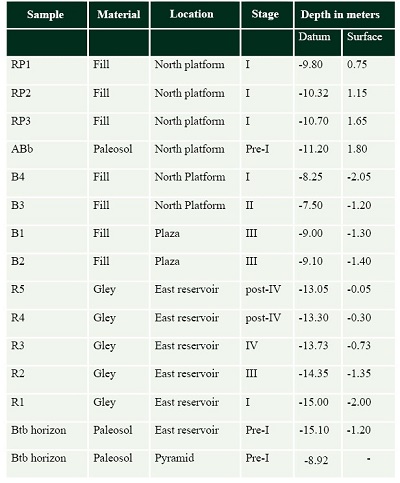
To corroborate the archaeological interpretation of the building sequence, we obtained 12 oriented and unaltered samples from: the fills of the North platform (RP1 to RP3 and B3-B4 samples); the fills of the (B1-B2 samples); the gleys found in the East reservoir (R1 to R5 samples). In addition, we collected three samples of paleosol horizons formed from a paleodune sediment, directly below the structures: beneath the Pyramid (Btb horizon), under the gleys (Btb horizon), and below the fills of the North platform (ABb horizon). The location of the archaeological samples is indicated on figure 1a and summarized in table 1. Additionally, one natural soil profile (La Joya profile 1) was studied inside the site (Figure 1a), and samples from every genetic horizon were taken.
| Table 1. Archaeological samples: location, depth and building stage. |
 |
2.4. MICROMORPHOLOGICAL ANALYSIS
The micromorphological analysis, based on the micromorphology manuals by Fitzpatrick (1984) and Loaiza et al. (2015), was carried out at the Institute of Geology at the National Autonomous University of Mexico (UNAM). The oriented samples of reservoir sediments, fills and natural soil horizons were impregnated with a polyester resin diluted with 30% styrene monomer and placed in vacuum for 40 minutes. The solid block was cut and ground using in sequence 120, 240, 360, 400 and 600 grit carborundum, then fixed to a 5x7 cm glass slide. Finally, the section was cut using a Buehler Petro Thin System to 50 mm, and further reduced to 30 micra, lapping by hand using 600 and then 1000 grit silicon carbide and mineral oil. The sections were analyzed using an Olympus BX51 petrographic microscope, connected to a Media Cybernetic Coolsnap Pro camera.
- Results
3.1. DESCRIPTION OF THE EARTHEN STRUCTURES PROFILES
At the North platform (number 2 in Figure 1), the fills of the first construction stage were analyzed (Figure 2). These fills (samples RP1- RP3) are below 90 cm of a later construction fill and rest directly on a buried ABb horizon. The three fills are similar: they have brownish colors, a clayey silty texture, they are compact and show a subangular blocky structure. Differences are observed in the amount of artifacts, being abundant in the upper fills (RP1 and RP2) and decreasing in the lower fill (RP3).
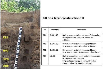 |
| Figure 2. Fills from the first construction stage at the North platform. |
Also in the North Platform, we sampled another building of the first and second construction stages (Figure 3a). The first building fill consists of a dark sandy loam with abundant charcoal flecks, sherds, obsidian, and animal bones. Sample B4 was taken from this layer, at 205 to 210 cm below modern surface and 40 cm below the floor sealing the first building stage fill, at 8.25 m below datum (Figure 3a). The earth from the second stage building is a light brown loam, with very few sherds. Sample B3 was taken from the fill of the platform supporting the so-called audience hall, a building used for special assembly purposes (Figure 1a), 120 to 125 cm below modern surface, and 35 cm above the floor of the first building stage, at -7.50 m below datum. The samples of the third building stage come from the fill of the plaza area to the West of the East Platform (labeled 3 in Figure 1a), about 350 m to the south of the pyramid (labeled 1 in Figure 1a). This fill contains sand mixed with clayey blocks of gray sediments, from which B1 and B2 samples were taken (Figure 3b), 120 to 140 cm below modern surface, and 80 cm above the plaza floor placed during the second building stage. Sample B1 is greyish and clayey, while sample B2 is a yellowish sand.
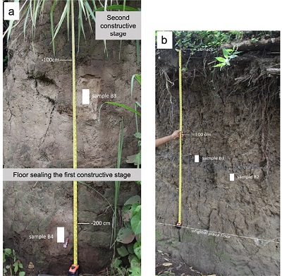 |
| Figure 3. Fills of: a. first and second construction stages, at the North platform; b. third construction stage, at the Plaza area. |
At the western edge of the East reservoir (number 5 in Figure 1a), a profile was exposed during recent land works. The size of the East reservoir is 500x75x2 m, totaling a volume of at least 75,000 m3; presently it is silted in and used as dry season cattle pasture, holding water only during the summer rains or major river floods. The profile measures 2.30 m from surface to phreatic level and consists of 6 strata (Figure 4). The one at the bottom is a sterile yellow sandy clay layer which corresponds to a Btb horizon formed from a paleodune sediment, apparently 30 cm above the phreatic level. Overlying the Btb horizon, a horizontal blue-gray layer, 65 cm thick, with some iron oxide concretions is observed (Sample R1). Directly on top of this stratum, there are two layers of large sherds, lying horizontally. The first one contains ceramic types dating to AD 100-300, and halfway up, while the second one has smaller sherds of types dating to AD 500-700. Above them, there is a thin horizontal layer of yellow gray gley, 10 cm thick (stratum 4- sample R2), very similar to the stratum 5 but with abundant iron concretions. The stratum 3 (sample R3) is a 55 cm thick-horizontal layer of light blue gray gley with abundant iron concretions dispersed in the stratum. We observe small sherds of ceramic types dating to AD 700-1000 as well as daub fragments, possibly of burnt roofs. Overlying this layer, a change is clearly observed, as the 40 cm thick-stratum 2 has dark brown colors (sample R4). It has clayey loam texture, with few sherds.
At the top of the sequence the stratum 1 (sample R5) is again a layer of gray gley with large iron oxide concretions, with some sherds of AD 100-700 types mixed with modern plastic garbage. This layer is 30 cm thick but is only present in the profile along the shore of the reservoir, disappearing upslope. The great similarity of this stratum with the lowest gley horizon (stratum 5) and the field evidence of modern infrastructure work, suggest that this layer is the result of the backhoe digging through the profile, heaping the mixed residues on the side, and compacting them on the surface by driving over it. This layer is absent from a reservoir trench dug in 2005 some 200 m to the north (Figure 1a, Daneels, 2005).
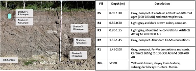 |
| Figure 4. Materials of the reservoir, showing in the bottom the Btb horizon of the natural surface. |
3.2. MORPHOLOGY OF THE NATURAL PROFILE
The natural profile (La Joya profile 1) is located immediately southwards from the profile where the B1 and B2 samples were obtained (Figure 1a) and has a total depth of 3.40 m (Figure 5), however the first 1.70 m corresponds to a soil formed in a sediment, as part of the 2 m fill placed over the surface during the third building stage; it contains abundant ceramics from the Middle and initial Late Classic (AD 400 and 700). At 1.90 m, a polycyclic paleosol is found. It has Aib, ABib1, 2ABb2, 2Btb3, 2Btgb4, 2BCb5, 2Cb6 horizons (Figure 5). The Aib and ABib1 horizons are dark brown with an angular blocky structure and a loamy texture. The uppermost Aib horizon is thin probably due to natural erosion or because of anthropic remotion. The 2ABb2 horizon is reddish brown, slightly more clayey; it has a subangular blocky structure. The 2Bt horizons (2Btb3 and 2Btgb4) are reddish brown. They have a loamy texture and a subangular blocky structure. Thin clay coatings and Fe-Mn nodules and mottles are visible with a 10X-lens. The lowermost horizons are brownish and yellowish. They are more sandy and less structured. Vertical fractures are observable, which enter down the profile, evidencing vertic features. Ceramic fragments are also seen along the profile, however, they can be the result of vertical transportation along the vertical fractures, as they are mainly found along them, sometimes together with modern materials from the surface, or from the activities of modern brick workers, active at this level of the profile.
Most earthen structures rest on an archaeologically sterile layer which corresponds to a yellowish brown Btb horizon of a buried paleosol, with a subangular blocky structure and clayey loam texture, presumably formed on a paleodune surface; in some areas, as in the East and North Platforms, a humic horizon (ABb horizon), rich in archaeological material, is found (Figure 2). It shows a dark brown color, a clayey loam texture and a subangular blocky structure.
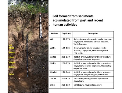 |
| Figure 5. Natural soil profile (La Joya profile 1) showing the modern soil and the buried polycyclic paleosol. |
3.3. MICROMORPHOLOGY OF THE FILLS IN THE EARTH BUILDINGS
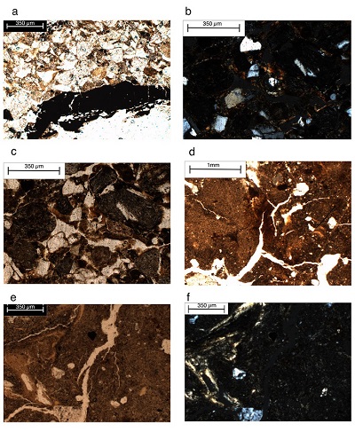
The fills at the North Platform (RP1 to RP3, first construction stage), contain abundant artifacts: pieces of ceramic where volcanic components are identified (Figure 6a, RP1); fragments of soils where oriented clay coatings are visible (Figure 6b, RP1) as well as Fe nodules (Figure 6c, RP2). Some areas present soil fragments that are crushed and pressed, consequently they have abrupt boundaries with the groundmass (Figure 6c). Unweathered volcanic glass particles are also found (Figure 6d, RP2).
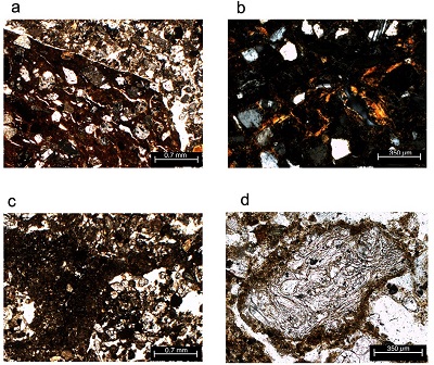 |
| Figure 6. Micromorphology of the fills of the first construction stage: a. ceramic fragment where volcanic materials are observed in RP1, plane-polarized light (PPL); b. illuvial clay coatings from a soil fragment in RP1, cross polarized light (XPL); c. dark soil fragment, crushed and compacted in RP2 (PPL); rounded Fe concretions are observed in the dark groundmass; d. volcanic glass fragment in a sand groundmass in RP2 (PPL). |
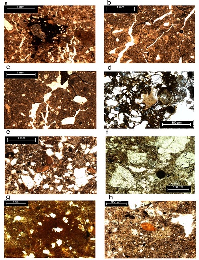
Sample B4, obtained from the North Platform (first stage of construction) has a subangular blocky structure (Figure 7a) with sand grains, mainly constituted by quartz, plagioclases and pyroxenes (Figure 7a). There are abundant anthropic artifacts, like obsidian flakes (Figure 7b), ceramics and charcoal (Figure 7b) as well as reworked clay coatings (Figure 7a and 7c). Sample B3 (second building stage) is massive (Figure 7d).
The groundmass is reddish brown, impregnated with iron oxides (Figure 7d) containing reworked clay coatings. High amounts of fine sand are observed (Figure 7d and 7e) composed mainly by quartz with some content of pyroxenes, and plagioclases. There are also rounded dark aggregates incorporated in the lighter groundmass (Figure 7d and 7e) and porous areas where charcoal fragments are present (Figure 7f).
 |
| Figure 7. Micromorphology of the fills of the first and second construction stages at North platform. B4 sample: a. subangular blocky structure (PPL); b. Obsidian flakes and charcoal (PPL); c. Re-worked, fragmented clay coatings in a sandy groundmass (XPL); B3 sample: d. rounded fragments made up fine sand in a fine sand groundmass with dark spots of Fe-oxides (PPL); e. same as d, (XPL); f. porous areas with charcoal and Fe oxides nodules (XPL). |
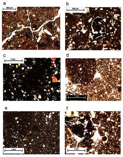
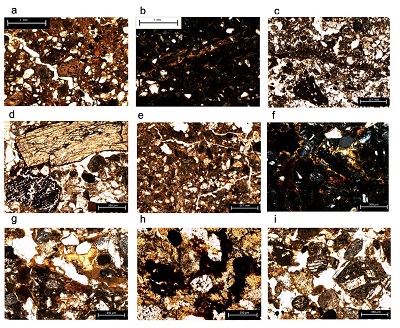
The B1 and B2 samples come from the third building stage fill. The B2 sample has a massive to subangular blocky structure with abundant pores and fractures. The groundmass is sandy (Figure 8a) with particles averaging 0.14 mm; fine clayey material exhibits a granostriated b-fabric (Figure 8a). The thin section also shows the presence of root fragments, charcoal (Figure 8a) and soil fragments where clay coatings are clearly observed (Figure 8b, c). The B1 sample is more clayey and has an angular blocky structure with planar voids and fissures (Figure 8d), fragmented clay coatings (Figure 8d), fine sand lenses and small sherd fragments. The average size of the sand particles is 0.12 mm in diameter. Another common feature is the presence of deformed and impure clay coatings (Figure 8e and 8f). The samples from the reservoir have the following features: R1 sample, at the bottom of the reservoir, has a clayey groundmass with planar voids (Figure 9a). Some areas have lighter colors, that together with the presence of Fe-Mn complex nodules (Figure 9a) indicate redoximorphic characteristics.
 |
| Figure 8. Micromorphology of the third construction stage. B2 sample: sandy groundmass with a granostriated b-fabric with charcoal fragments (PPL); b. soil fragments with clay coatings in a sandy groundmass (XPL); B1 sample: c. compact soil fragments in a sandy groundmass (PPL); d. compact soil aggregates with a subangular blocky structure, with clay coatings; e. compact clayey aggregates with dirty and deformed clay coatings (PPL); f. same as e, with XPL. |
The overlying stratum (sample R2) is more clayey, with a subangular blocky structure (Figure 9b). Abundant planar voids and fissures, together with elongated pores are observed (Figure 9b). In this layer, Fe nodules are also detected. Additionally, dusty clay coatings are present, which are weakly oriented (Figure 9c).
Sample R3, from the stratum 3, is more sandy and poorly structured (Figure 9d). The particles are mostly subrounded and are mainly constituted by volcanic rock fragments and plagioclases. Rounded soil aggregates, having thick clay coatings, some of them fragmented, are also present (Figure 9e). The sample R4, located near the surface, has also a coarse texture and is less compact (Figure 9f). The sand particles are floating in a silty-clay groundmass (Figure 9f). The coarse components include volcanic glass and fragments of ceramic. In contrast, the uppermost stratum, sample R5, is highly compact (Figure 9g). The groundmass is composed by reddish clay with few biogenic pores, and a high content of iron mottles with diffuse limits (Figure 9g). The sand mineral particles are subrounded. Although the general appearance is clayey and compact, there are areas with coarser textures where fragmented clay coatings are observed (Figure 9h).
 |
| Figure 9. Micromorphology of the reservoir. a. R1 sample clayey groundmass with planar voids and Fe-Mn complex nodules (PPL); R2 sample: b. subangular blocky structure with planar voids, fissures, and elongated pores (PPL); c. dusty clay coatings, weakly oriented (PPL); R3 sample: d. sandy and poorly structured groundmass (PPL); e. rounded soil aggregates, having thick clay coatings (PPL); R4 sample: f. coarse texture with subangular mineral grains (PPL); g. sand particles are floating in a silty-clay groundmass (PPL). R5 sample: h. compact and clayey groundmass, impregnated with Fe; areas with coarser textures where fragmented clay coatings are present (PPL). |
3.4. MICROMORPHOLOGY OF THE NATURAL SOILS
Micromorphology of the Btb horizon of the (decapitated) paleosol underlying all the earthen constructions, shows a subangular blocky structure with planar fractures (Figure 10a). The coarse particles include rock fragments of andesite, plagioclase, pyroxenes, micas, and some amphiboles; their average size is 0.15 mm in diameter (Figure 10a and 10b). Thick in situ clay coatings are clearly observed (Figure 10b). At the bottom of the fills in the North Platform, the buried ABb horizon shows fine sand and silt particles, impregnated with organic matter (Figure 10c). The fine particles are aligned and deformed (Figure 10c), evidencing crushing and compaction of the material. In this horizon, we also observed bone and charcoal fragments (Figure 10d).
 |
| Figure 10. Micromorphology of the natural paleosols: a. Btb horizon under the earthen constructions, showing a subangular blocky structure with planar fractures and fragments of andesite (PPL); b. illuvial clay coatings in the Btb horizon (XPL); c. ABb horizon showing a dark groundmass where fine particles are aligned and deformed (PPL); d. bone and charcoal fragments in the ABb horizon (PPL); e. angular blocky structure of the ABib1 horizon (PPL); f. two generations of in situ clay coatings of strong birefringence: one with a reddish color and another with a yellowish color in the 2Btb3 horizon (XPL); g. two generations of clay coatings accompanied by Fe oxides nodules and accumulations in the 2Btgb4 (PPL); h. altered sand grains with complex and single Fe nodules (PPL); i. plagioclases, volcanic rock fragments covered by thin clay coatings (PPL). |
The ABib1 horizon of the natural profile excavated in the south of the main pyramid (Figure 5) shows a dark groundmass where angular blocks are clearly defined (Figure 10e). The Bt horizons in this profile (2Btb3, 2Btgb4) shows two generations of undisturbed clay coatings of strong birefringence: one with a reddish color and another with a yellowish color (Figure 10f and 10g). In the 2Btgb4, there are abundant redoximorphic features as single Fe nodules, complex Fe nodules (Figure 10h) and Fe coatings (Figure 10h). The 2Cb6 horizon shows the presence of sand grains with different degrees of alteration. They consist of plagioclases, rock fragments, pyroxenes, and quartz (Figure 10i). The horizon has a granostriated b-fabric with thin clay coatings around the minerals (Figure 10i).
- Discussion
4.1. NATURAL PALEOPEDOGENESIS IN LA JOYA ARCHAEOLOGICAL SITE
The natural profile studied in the area contains a set of features that can be decodified to reconstruct the paleopedogenesis. Although this is the only complete profile we have studied, below the earthen structures, a consistent buried paleosol horizon has been found, whose properties can be also related to those of the natural soil profile. In general, the paleosol is archaeologically sterile, however, the surface of the La Joya profile 1 (Aib and ABib1 horizons) has ceramic fragments as well as AB horizons buried below some of the structures. Although some ceramic pieces have also been observed in the lower horizons, they appear to be linked to fractures. Therefore, we consider they have been vertically transported, as bioturbation and/or shrinkage and swelling processes can disturb the stratigraphical context (Leigh, 1998; Driese et al., 2013). The second paleosol level identified in the La Joya profile 1 (2ABb2, 2Btb3, 2Btgb4, 2BCb5, 2Cb6) is characterized to show a reddish-brown color, with a high amount of sand, but with an evident increase of clay in the 2ABb2 and in the 2Btb3 and 2Btgb4 horizons (García-Zeferino, 2020), contrasting to the dominance of sand fraction in the 2Cb6 horizon, what suggests the clay has been formed by pedogenesis. Thin sections support this suggestion as thick in situ clay coatings are observed in the Bt horizons of the buried paleosol (Figures 10b, 10f and 10g). Even more, in this paleosol, different generations of clay coatings are identified, which are related to a long time of landscape stability, necessary to firstly, form the clay from the sand (parent material from the paleodune), secondly to illuviate the clay along the profile. Studies of soil formation on dune sediments indicate a long-time span for the formation of Bt horizons (Phillips, 2007). The coatings reduce the soil porosity, producing redoximorphic conditions (Buurman et al., 1998), which are observed in form of Fe-Mn segregations and concretions (Figures 10g, 10h and 10i). In contrast, the micromorphology of weakly developed soils on sandy sediments in different parts of the world show the presence of fresh single grains only impregnated with organic matter or a microstructure of intergrain micro-aggregate (Hinojosa et al., 2015; Stoops et al., 2020). This kind of microstructures is seen in the 2Cb6 horizon (Figure 10i).
In the Veracruz coast, north to La Joya, the presence of Bt horizons has been registered, belonging to buried paleosols formed during the Late Pleistocene; in contrast, the early to middle Holocene paleosols develop vertic features (Solleiro-Rebolledo et al., 2021). Mid Holocene vertic paleosols were encountered also more to the south in the Usumacinta valley, Tabasco, also under present day humid tropical climate (Solís-Castillo et al., 2015). Therefore, we suggest the polycyclic paleosol in La Joya represents these two main cycles of pedogenesis: the buried Bt horizons under the structures as well as those observed in the La Joya profile 1 belong to a Pleistocene pedogenetic phase, while the vertic horizons on top (Aib and ABib1 horizons) are formed in the Holocene, previously to the site’s occupation. However, these horizons show evidence of human use, as compaction (Figure 10c) and a high amount of artifacts as charcoal and bones mixed with the natural components (Figure 10d). This observation is supported by the archaeological findings which indicate the site was occupied for almost a millennium, prior the development of the earthen structures (Daneels and Guerrero-Baca, 2011).
4.2. CORRELATION BETWEEN FILLS AND SOILS: MICROMORPHOLOGICAL INDICATORS
When we compare the micromorphological characteristics of the RP1, RP2 and RP3 samples, from the North Platform, representing the first building stage, there are interesting features: the material found in the RP2 is like the ABb horizon of the natural soil, where dark granules are visible (Figure 10c), but in the case of the fill, the material has been crushed and compacted (Figure 6c) and mixed with volcanic materials, which look mostly fresh (Figure 6d) and with fragments of the Btb horizon, identified by the presence of illuvial clay coatings (Figure 6b). This kind of fill is known as structured fill, where sediments of different textures are layered in order to increase the structural stability of the construction (Daneels et al., 2018). The sample B4, also from the North Platform, has similar characteristics of the Btb and Btgb horizons: it has a subangular blocky structure, like the one observed in the natural horizon (Figure 7a, 10a,10e), reworked clay coatings (Figure 7a, 7c) as well as reddish areas impregnated with iron oxides (Figure 7d).
The fill also contains sherds, obsidian, and charcoal, which are not associated to the Btb horizon fragments. Therefore, it is not likely that the inhabitants of the site mixed these materials intentionally with the soil. It is probable that the artifacts were unintentionally integrated to the natural soils, as residues (residential and agricultural trash) of the early occupation period of the site, that became integrated to the surficial A horizon before the start of the site’s monumental constructions. This confirms the archaeological inference that when the first building stage began, this A horizon, rich in human refuse, was extracted and used as fill.
The B3 sample features differ from the Btb horizon of the paleosol. In the fill, the sand grains are finer (Figures 7d, 7e) with charcoal fragments (Figure 7f). There are also rounded dark fragments of fine texture, rich in quartz (Figure 7d) that are not present in the paleosol samples. The source of this material is not clear but can be related to sediments from the neighboring coastal areas of Veracruz, which contain less amount of lithics and higher content of quartz (Armstrong-Altrin et al., 2015).
The fills of the third construction stage at the plaza area have common micromorphological features with the paleosol. Nevertheless, the B1 sample has a coarser texture with a granostriated b-fabric (Figure 8a) land looks like the 2Cb6 horizon of the natural soil (Figure 10i), but the fill has charcoal fragments (Figure 8a). The B2 sample is more clayey with compact aggregates (Figure 8d) where clay illuvial coatings are clearly observed that relates this material to the Btb horizons of the natural soil. In addition, the fill has abundant material of anthropic origin: sherds, obsidian, and charcoal. As some features are also similar to the earth of the reservoirs (presence of compact clay, impure and deformed clay coatings, planar voids and fissures Figure 9d, 9e), we suggest that the sediment from the reservoir was used during the third construction stage; this supports the archaeological observations that some fill material was extracted from this area.
Although the pedofeatures found in the strata of the reservoir share similarities with those of the natural soils, there are transformations due to the permanent waterlogged conditions of the reservoir. The oldest strata (samples R1 and R2) are compact with illuvial clay pedofeatures, like those observed in the buried Bt horizon, however in the case of the reservoir, they seem to be deformed (Figure 9b), not limpid and weakly oriented with diffuse boundaries with the groundmass (Figure 9a, 9b) that probably fit in the concept of flood coatings (Singh et al., 1998; Boixadera et al., 2003). Therefore, it is probable that the source for these strata is the paleosol affected by the water of the reservoir. The third stratum (sample R3) has a coarser texture. The sand grains are surrounded by dusty clay mixed with limpid clay fragments (Figure 9d). Its mineralogy (volcanic rock fragments and plagioclases) and grain size indicate this material proceeds from the 2BCb5 and 2Cb6 horizons of the paleosol (Figure 10h, 10i).
The stratum 2 (sample R4) is similar to the R3, but here, the material is mixed with ceramics and volcanic glass. Particularly concerning the volcanic glass, we have not seen it in the paleosol, but it can be transported by the rivers Jamapa and Cotaxtla, proceeding from the Pico de Orizaba volcano, which had intensive activity during the Holocene (Carrasco-Núñez, 2000). In consequence, the results support the previous interpretation derived from the archaeological stratigraphic reconstruction, that these sediments are of fluvial origin (Daneels, 2005). Additionally, the coastal sediments of Veracruz are rich in quartz, with some amounts of plagioclases and volcanic lithics (Armstrong-Altrin et al., 2015). In consequence, these sediments can also be a source for the sandy material found in the stratum. The uppermost material found in the reservoir has similarities with those observed in the lower strata: compact clayey, Fe-Mn nodules and impregnations with fragmented clay coatings (Figure 9g, 9h). However, the stratum was only locally found (not observed in a trench dug in 2005) and lays 2 m above the present-day phreatic level, so that the apparent conditions for waterlogging are improbable. Besides these characteristics, it is mixed with ceramic of different ages and modern plastics (Figure 4), thus it represents a reworked material, product of recent infrastructure work.
- Conclusions
This article presents a case of application of micromorphology to corroborate the interpretation of the building sequence of an archaeological site, by comparing the construction fills with the probable sources from which the material was obtained. The size and form of the particles was important to evaluate the use of paleodune and coastal sediments versus the sediments from the alluvial terraces. Additionally, it was possible to correlate specific features found in a natural soil buried below the structures and the fills used in every construction stage.
In the first construction stage, the features of the fills coincide with those observed in the natural soil, particularly to the Btb, Btgb and Ab horizons, and even to the sands of the paleodune; while the second construction stage included material from the natural soil as well as from the alluvial sediments.
Besides these natural sources, anthropic materials (charcoal, bones, ceramic) were observed in the fills. Nevertheless, the archaeological evidence has shown that the artifacts were not intentionally added to these early fills. On the contrary, they were integrated into the soils as residues of the first occupation period of the site. Later, the surficial organic horizon enriched with this residential and agriculture trash was used for the construction. This conclusion is based in the fact the Btb horizon, also employed as building material, lacks artifacts. On the other hand, in some fills there is evidence the material was crushed and compacted using a technique named structured fill.
The strata of the reservoir also demonstrated they came from the natural soils and sediments of the region probably accumulated during the construction and the occupation of the site. However, the materials had been transformed by the waterlogging conditions, being a case of anthropogenic pedogenesis.
This interpretation is based on the absence of dark, organic horizons that would be present in case of the natural ponds (swamps) in a humid tropical environment. During the third construction stage, the inhabitants used the sediments from the paleodune as well as from the reservoir as they share common features, particularly, fragments of compact clay with redoximorphic characteristics combined with sandy sediments.
Contributions of authors
Field work, micromorphology of the fills and paleosols, results section: Thania García-Zeferino; Field work, archaeological descriptions, funding, writing of the paper: Annick Daneels; Field work, micromorphology of the reservoirs: Jaime Díaz Ortega; Integration of micromorphological observations, writing of the paper: Elizabeth Solleiro-Rebolledo.
Financing
This paper was possible thanks to the financial support given to A. Daneels by UNAM-DGAPA-PAPIIT grant IN400816 and CONACyT grant CB2015-25432.
Acknowledgements
Authors are grateful to the Consejo de Arqueología del Instituto Nacional de Antropología e Historia, for the excavation permissions in the archaeological site as well as for the permissions to analyze the materials collected from the site and to reproduce the figures included in this article, as required by the Mexican Federal Law on Archaeological Monuments and Zones. We appreciate the support of the landowners who permitted the extensive field seasons of the archaeological team. We are gratefully to Sergey Sedov for his ideas during the field work and for his assistance in the micromorphological interpretation. The comments and suggestions of the reviewers were also very valuable to improve the quality of the paper.
Conflicts of interest
The authors confirm the absence of conflicts of interest.
References
Armstrong-Altrin, J.S., Nagarajan, R., Balaram, V., Natalhy-Pineda, O., 2015, Petrography and geochemistry of sands from the Chachalacas and Veracruz beach areas, western Gulf of Mexico, Mexico: Constraints on provenance and tectonic setting: Journal of South American Earth Sciences, 64, 199-216. http://dx.doi.org/10.1016/j.jsames.2015.10.012
Barba, L., 1995, El impacto humano en la paleogeografia de Teotihuacan México: Universidad Nacional Autónoma de México, Facultad de Filosofía y Letras, Tesis Doctoral, 92 pp.
Barba, L., Blancas, J., Ortíz, A., Manzanilla, L., Barca, D., Crisci, G., Miriello, D., Pecci, A., 2009, Provenance of the limestone used in Teotihuacan (Mexico): A methodological approach: Archaeometry, 51 (4), 525–545. https://doi.org/10.1111/j.1475-4754.2008.00430.x
Bezada, M., Barros, H., Zavala, M., Pedraza, E., Foghin, S., González, O., Godoy, D., Zambrano, E., Herrera, R., Leal, A., 2021, Earthen ridges in coastal sand dunes of the Caribbean coast, Venezuela: Anthropogenic or natural?: Geoarchaeology: An International Journal, 36, 351-362. https://doi.org/10.1002/gea.21835
Blancas, J., Barba, L., Carballo, D., Solleiro-Rebolledo, E., Sedov, S., Díaz, J., 2019, Análisis de indicadores arqueológicos de Tlajinga, Teotihuacan: Boletín de la Sociedad Geológica Mexicana, 71, 457-479. http://dx.doi.org/10.18268/BSGM2019v71n2a14
Boixadera, J., Poch, R.M., García-González, M.T., Vizcayno, C., 2003, Hydromorphic and clay-related processes in soils from the Llanos de Moxos (northern Bolivia): Catena, 54, 403-424. http://dx.doi.org/10.1016/S0341-8162(03)00134-6
Butzer, K., 1982, Archaeology as human ecology: Cambridge, Cambridge University Press, 364p. https://doi.org/10.1017/CBO9780511558245.
Buurman, P., Jongmans, A.G., PiPujol M.D., 1998, Clay illuviation and mechanical clay infiltration - Is there a difference?: Quaternary International, 51-2, 66-69. http://dx.doi.org/10.1016/S1040-6182(98)90225-7
Carranza-Edwards, A., Rosales-Hoz, L., 1995, Grain size trends and provenance of southwestern Gulf of Mexico beach sands: Canadian Journal of Earth Sciences, 32, 2009-2014. https://doi.org/10.1139/e95-153
Carrasco-Núñez, G., 2000, Structure and proximal stratigraphy of Citlaltépetl volcano (Pico de Orizaba), Mexico, in Delgado-Granados, H., Aguirre-Díaz, G.J., Stock, J.M.,(eds.), Cenozoic tectonics and volcanism of Mexico: USA, Geological Society of America Special Paper, 334, 247-262. https://doi.org/10.1130/0-8137-2334-5.247
Courty, M.-A., 1991, Soil micromorphology in archaeology: Proceedings of the British Academy, 77, 39-59.
Courty, M.-A., Goldberg, P., Macphail, R.I., 1989, Soils and micromorphology in archaeology: Cambridge, Cambridge University Press, 344p.
Da Costa, M.L., Kern D.C., 1999, Geochemical signatures of tropical soils with archaeological black earth in the Amazon, Brazil: Journal of Geochemical Exploration, 66, 369 – 385. https://doi.org/10.1016/S0375-6742(99)00038-2
Daneels, A., 2005, Exploraciones en el Centro de Veracruz. Temporada IX: Temporalidad y función de la Arquitectura de Tierra: Mexico City, Archivo Técnico de la Coordinación de Arqueología del Instituto Nacional de Antropología e Historia, Informe Técnico.
Daneels, A., 2008, Monumental earthen architecture at La Joya, Veracruz, Mexico: California, Foundation for the Advancement of Mesoamerican Studies, 1-25.
Daneels, A., 2016, Juego de pelota y política. Un estudio sobre cómo se desarrolló la sociedad del periodo Clásico en el centro de Veracruz: Mexico City: Instituto de Investigaciones Antropológicas, Universidad Nacional Autónoma de México, 693p.
Daneels, A., Guerrero-Baca L.F., 2011, Millenary earthen architecture in the tropical lowlands of Mexico: APT Bulletin 42, 11-18.
Daneels, A., Love, M., Ávalos-Beltrán, E., 2018, Control de presión interna de rellenos en basamentos de la Mesoamérica prehispánica, in Neves, C., Salcedo-Gutiérrez, Z., Borges-Faria, O. (eds.), Memorias 18 Seminario Iberoamericano de Arquitectura y Construcción con Tierra: Tierra, Cultura, Habitat Resiliente y Desarrollo Sostenible: La Antigua, Guatemala, USAC-CII/PROTERRA, 36-45.
Devos, Y., Wouters, B., Vrydaghs, L., Tys, D., Bellens, T., Schryvers, A., 2013, A soil micromorphological study on the origins of the early medieval trading centre of Antwerp (Belgium): Quaternary International, 315, 167-183. http://dx.doi.org/10.1016/j.quaint.2013.07.014
Driese, S.G., Nordt, L.C., Waters, M.R., Keene, J.L., 2013, Analysis of site formation history and potential disturbance of stratigraphic context in vertisols at the Debra L. Friedkin Archaeological Site in Central Texas, USA: Geoarchaeology, An International Journal, 28, 221-248. https://doi.org/10.1002/gea.21441
Escalona, A., 1937, Ruinas de “El Tejar”: Mexico City, Instituto Nacional de Antropología e Historia, Informe Técnico (unpublished report).
Finsten, L., Kowalewski, S.A., Smith, C.A., Borland, M.D., Garvin, R.D., 1996, Circular Architecture and Symbolic Boundaries in the Mixtec Sierra, Oaxaca: Ancient Mesoamerica, 7, 19-35. https://doi.org/10.1017/S0956536100001267
Fisher, P.F., Macphail, R.I., 1985, Studies in archaeological soils and deposits by micromorphological techniques, in Feiller, N., Gilbertson, D.D., Ralph, N.G.A. (eds.), Paleoenvironmental Iinvestigations: Research, design, method and data analysis: Oxford, British Archaeological Reports International Series, 258, 93-112.
Fitzpatrick, EA., 1984, Micromorphology of soils: New York, Chapman and Hall, 434p. https://doi.org/10.1007/978-94-009-5544-8
Gama-Castro, J.E., Cruz y Cruz, T., Pi-Puig, T., Alcalá-Martínez, R., Cabadas-Báez, H., Jasso-Castañeda, C., Díaz-Ortega, J., Sánchez-Pérez, S., López-Aguilar, F., Vilanova de Allende, R., 2012, Arquitectura de tierra: el adobe como material de construcción en la época prehispánica: Boletín de la Sociedad Geológica Mexicana 64(2), 177-188. http://dx.doi.org/10.18268/BSGM2012v64n2a3
García, E., 1970, Los climas del estado de Veracruz (según el sistema de clasificación climática de Köppen modificado por la autora): Anales del Instituto de Biología, UNAM, 41(1), 3-42.
García-Zeferino, T.A., 2020, El suelo como fuente de materia prima en la arquitectura de tierra de Mesoamérica antigua: México, Universidad nacional Autónoma de México, Master Thesis, 145p.
Gill, R.B., 2000, The great Maya droughts: Water, life, and death: Albuquerque, University of New Mexico Press, 464p.
Hinojosa, F.C., Nooren, K., Solleiro-Rebolledo, E., Sedov, S., Salazar, O., 2016, Soil development on a beach ridge chronosequence in the Gulf of Mexico coastal plain and its relation to the ancient land use: Quaternary International, 418, 180-194. https://doi.org/10.1016/j.quaint.2015.12.037
Itkin, D., Crouvi, O., Monger, H.C., Shaanan, U., Goldfus, H., 2018, Pedology of archaeological soils in tells of the Judean foothills, Israel: Catena 168, 47-61. https://doi.org/10.1016/j.catena.2018.03.014
Kasper-Zubillaga, J.J., 1999, Análisis de ambientes sedimentarios recientes de la región costera norcentral de Veracruz, México: Universidad Nacional Autónoma de México, PhD Thesis, 163p.
Khokhlova, O.S., Nagler, A.O., 2020, The Marfa Kurgan in the Stavropol territory: An example of an ancient architectural structure: Archaeology, Ethnology and Anthropology of Eurasia, 48, 38-48. https://doi.org/10.17746/1563-0110.2020.48.2.038-048
Laporte, L., Bizien-Jaglin, C., Wattez, J., Guyodo, J-N., Barreau, J-B., Bernard, Y., Aoustin, D., Guitton, V., Hamon, G., Jallot, L., Lucquin, A., March, R., Marcoux, N., Mens, E., Soler, L., Werthe, E., 2015, Another brick in the wall: fifth millennium BC earthen-walled architecture on the Channel shores: Antiquity 89, 800-817. https://doi.org/10.15184/aqy.2015.55
Leigh, D.S., 1998, Evaluating artifact burial by eolian versus bioturbation processes, South Carolina Sandhills, USA: Geoarchaeology: An International Journal, 13, 309–330. https://doi.org/10.1002/(SICI)1520-6548(199802)13:3<309::AID-GEA4>3.0.CO;2-8
Liberotti, G., Daneels A., 2012, Adobes en arquitectura monumental: análisis químico-físicos para determinar las técnicas constructivas en los sitios de La Joya (México) y Arslantepe (Turquía): Boletín de la Sociedad Geológica Mexicana, 64, 79-89. http://dx.doi.org/10.18268/BSGM2012v64n1a7
Loaiza, J.C., Stoops, G., Poch, R.M., Casamitjana, M., 2015, Manual de micromorfología de suelos y técnicas complementarias: Colombia, Fondo Editorial Pascual Bravo, 384p.
Macphail, R.I., Goldberg, P., 2017, Applied soils and micromorphology in archaeology: Cambridge Cambridge, University Press, 600p. https://doi.org/10.1017/9780511895562
McClung, E., Villalpando, J.L., Solleiro-Rebolledo, E., Gama-Castro, J., 2004, Prácticas agrícolas en el valle de Teotihuacan, Edo. de México: evidencias químicas y micromorfológicas, in Manzanilla, L., Miranbell, L., Benavides, A.C., (eds.), Homenaje a Jaime Litvak King: México, Instituto de Antropología e Historia e Instituto de Investigaciones Antropológicas, 63-80.
Pérez, N.A., Bucio, L., Lima, E., Soto, E., Cedillo, C., 2016, Identification of allophane and other semi-crystalline and amorphous phases on pre-Hispanic Mexican adobe earth bricks from Cholula, Mexico: Microchemical Journal, 126, 349–358. http://dx.doi.org/10.1016/j.microc.2015.12.033
Phillips, J.D., 2007, Development of texture contrast soils by a combination of bioturbation and translocation: Catena, 70, 92-104. https://doi.org/10.1016/j.catena.2006.08.002
Rivera-Uria, Y., Sedov, S, Solleiro-Rebolledo, E., Pérez-Pérez, J., McClung, E., González, A., Gama-Castro, J., 2007, Degradación ambiental en el valle de Teotihuacan: evidencias geológicas y paleopedológicas: Boletín de la Sociedad Geológica Mexicana, 59, 203-217. http://dx.doi.org/10.18268/BSGM2007v59n2a5
Silva-Mora, L., 2009, Petrographic analysis of 25 samples from La Joya, Municipio de Medellín, Veracruz: México, Universidad Nacional Autónoma de México, Instituto de Geología, Unpublished Report.
Singh, L.P., Parkash, B., Singhvi, A.K., 1998, Evolution of the Lower Gangetic Plain landforms and soils in West Bengal, India: Catena, 33, 75–104. https://doi.org/10.1016/S0341-8162(98)00066-6
Solís-Castillo, B., Golyeva, A., Sedov, S., Solleiro-Rebolledo, E., López-Rivera, S., 2015, Phytoliths, stable carbon isotopes and micromorphology of a buried alluvial soil in Southern Mexico: A polichronous record of environmental change during Middle Holocene: Quaternary International, 365, 150-158. http://dx.doi.org/10.1016%2Fj.quaint.2014.06.043
Solleiro-Rebolledo, E., Sedov, S., McClung, E., Cabadas, H., Gama-Castro, J., Vallejo-Gómez, E., 2006, Spatial variability of environment change in the Teotihuacan valley during late Quaternary: paleopedological inferences: Quaternary International, 156-157, 13-31. https://doi.org/10.1016/j.quaint.2006.05.003
Solleiro-Rebolledo, E., Sedov, S., Terhorst, B., López-Martínez, R., Díaz-Ortega, J., Díaz-Hernández, Y., Valera-Fernández, D., Cabadas-Báez, H., Tsukamoto, S., 2021, Late Quaternary paleosols and landscape evolution in dune systems of Veracruz at the Gulf of Mexico coast: Quaternary International, https://doi.org/10.1016/j.quaint.2021.05.016
Stoops, G., Langohr, R., Van Ranst, E., 2020, Micromorphology of soils and palaeosoils in Belgium. An inventory and meta-analysis: Catena, 194, 104718. https://doi.org/10.1016/j.catena.2020.104718
Straulino, L., Sedov, S., Michelet, D., Balanzario, S., 2013, Weathering of carbonate materials in ancient Maya constructions (Río Bec and Dzibanché): Limestone and stucco deterioration patterns: Quaternary International, 315, 87-100. http://dx.doi.org/10.1016/j.quaint.2013.06.019
Sulas, F., Kristiansen, S.M., Wynne-Jones, S., 2019, Soil geochemistry, phytoliths and artefacts from an early Swahili daub house, Unguja Ukuu, Zanzibar: Journal of Archaeological Science, 103, 32-45. https://doi.org/10.1016/j.jas.2019.01.010
Williams, R., Errickson, D., Taylor, G., 2021, Mapping an archaeological site: Interpreting portable X-ray fluorescence (pXRF) soil analysis at Boroughgate, Skelton, UK: Journal of Archaeological Science Reports, 38, 103109. https://doi.org/10.1016/j.jasrep.2021.103109
Wilson, C.A., Davidson, D.A., Cresser, M.S., 2005, An evaluation of multielement analysis of historic soil contamination to differentiate space use and former function in and around abandoned farms: Holocene, 15, 1094-1099. https://doi.org/10.1191/0959683605hl881rr
Peer Reviewing under the responsibility of Universidad Nacional Autónoma de México.
This is an open access article under the CC BY-NC-SA license(https://creativecommons.org/licenses/by-nc-sa/4.0/)