
|
Boletín de la Sociedad Geológica Mexicana Volumen 74, núm. 3, A061022, 2022 http://dx.doi.org/10.18268/BSGM2022v74n3a061022
|
 |
Soil-archaeological studies of Koy-Gunzhar Scythian tumuli (Kazakhstan):
building materials and techniques, diagenetic transformations of buried paleosols
Estudios de suelo y arqueológicos de los túmulos escíticos de Koy-Gunzhar (Kazajistán):
materiales y técnicas de construcción, transformaciones diagenéticas de paleosuelos sepultados
Denis A. Gavrilov1, †, Maria A. Bronnikova2, Maral K. Khabdulina3, Alexey N. Sviridov4,*
1 Laboratory of Soil Geography and Genesis, Institute of Soil Science and Agrochemistry,SB RAS, Lavrentieva 8/2, 630090, Novosibirsk, Russia.
2 Department of Soil Geography and Evolution, Institute of Geography, RAS, Staromonetnij 29, 119017, Moscow, Russia.
3 K.A. Akishev Research Institute of Archaeology, L.N. Gumilyov National Eurasian University, Satbaeva 2, 010000, Nur-Sultan, Kazakhstan.
4 Department of Preserving Archaeological Heritage, Institute of Archaeology RAS, Ulyanova 19, 117292, Moscow, Russia.
† Deceased.
* Corresponding author: (A. Sviridov) This email address is being protected from spambots. You need JavaScript enabled to view it.
How to cite this article:
Gavrilov, D.A., Bronnikova, M.A., Khabdulina, M.K., Sviridov, A.N., 2022, Soil-archaeological studies of Koy-Gunzhar Scythian tumuli (Kazakhstan): building materials and techniques, diagenetic transformations of buried paleosols Koy-Gunzhar Scythian tumuli: building technologies, and buried paleosols: Boletín de la Sociedad Geológica Mexicana, 74 (3), A061022. http://dx.doi.org/10.18268/BSGM2022v74n1a061022
Manuscript received: October 7, 2021; Corrected manuscript received: October 6, 2022; Manuscript accepted: October 12, 2022.
ABSTRACT
The tumuli of the Koy-Gunzhar burial ground (2400-2000 cal years BP) in the North Kazakhstan are monumental earthen mounds, built in honour of the Scythian elite. The tumuli, besides representing the diversity of the building techniques for such earth burial mounds, also provide a unique opportunity to study the direction and character of the paleosol diagenesis for nearly 2400 years. This soil-archaeological study aimed to reveal mound building techniques, the characteristics of materials used for construction, and diagenetic changes of the buried paleosols. The comparative analysis of tumulus embankments and buried soils (their genesis and diagenetic transformations) provided the opportunity to establish the source of the building material and to reconstruct some details of the building technologies. For instance, the Calcic Someric Kastanozem (Arenic, Protosodic), buried by loam-sandy and sandy substrate of the tumulus 3, corresponds to dry steppe conditions and has no considerable signs of diagenetic transformations, whereas the paleosol under the tumulus 1 was affected by strong diagenetic transformation supposedly due to acid drainage from the embankment which originally contained sulfidic material being subjected to oxidation and acidification after the tumulus construction. Diagenesis was manifested in the redistribution of pedogenic carbonates and enrichment in iron, magnesium, manganese, and aluminum compounds in the upper 32 cm of the buried soil. These elements were partially accumulated at the carbonate geochemical barrier (over Bk horizon of the buried soil). This soil was transformed by diagenesis from Kasrtanozem to Mollic Cambic Umbrisol (Epiloamic, Katoarenic). The builders of the tumulus 1 used a loamier substrate to construct the mound, different from the parent material for adjacent soils (loamy sands and sands). The loamier substrate ensured the firmness of the mound construction. The builders employed an uncommon technique to produce a mound with defined properties and used foreign building materials brought from the distance.
Keywords: tumuli, building technologies, paleosols, diagenesis, sulfidic material.
RESUMEN
Los túmulos del cementerio de Koy-Gunzhar (2400-2000 cal años AP) en el norte de Kazajistán son montículos de tierra monumentales construidos para conmemorar la élite escita. Los túmulos aparte de presentar una diversidad de las técnicas constructivas de los montículos funerarios de tierra, también proporcionan una oportunidad de estudiar la dirección y carácter de diagénesis de paleosuelos en el transcurso de casi 2400 años. Este estudio edafo-arqueológico pretende establecer las técnicas constructivas de los montículos, características de materiales usados para la construcción y cambios diagenéticos de los paleosuelos sepultados. Se realizo un análisis comparativo de los rellenos de túmulos y suelos sepultados (su génesis y transformación diagenética) que permitió establecer la fuente del material constructivo y reconstruir algunos detalles de las tecnologías de construcción. Por ejemplo, Calcic Someric Kastanozem (Arenic, Protosodic) sepultado por un sustrato de loan-arenoso y arenoso del túmulo 3 corresponde al ambiente seco estepario y no tiene evidencias considerables de una transformación diagenética. Por otro lado, el paleosuelo subyaciente del túmulo 1 fue afectado por una transformación diagenética fuerte supuestamente causada por el drenaje ácido proveniente del relleno que originalmente había contenido material sulfurado sujeto a oxidación y acidificación después de la construcción del túmulo. La diagénesis se manifestó en la redistribución de los carbonatos pedogénicos y enriquecimiento en 32 cm superiores del suelo sepultado con los compuestos de hierro, magnesio, manganeso y aluminio. Esos elementos se acumularon en la barrera geoquímica carbonatada (sobre el horizonte Bk del suelo sepultado). Este suelo fue transformado de un Kastanozem a Mollic Cambic Umbrisol (Epiloamic, Katoarenic). Los constructores del túmulo 1 utilizaron un sustrato de textura más fina para construir el montículo, diferente del material parental de los suelos aledaños (loan arenoso y arena). El uso de loan más fino proporcionó mayor dureza a la construcción del montículo. Los constructores utilizaron una tecnología poco común para producir un montículo con características deseadas y utilizaron materiales constructivos foráneos encontrados a distancia.
Palabras clave: túmulos, tecnologías de construcción, paleosuelos, diagénesis, material sulfurado.
- Introduction
A tradition of constructing tumuli (burial mounds), sustained over the last six thousand years, made such mounds an integral element of the steppe landscape. Rising over the plain surfaces, the tumulus mounds provide evidence of the long-time and extensive use of Eurasian steppes by man, the advancement of cultural and historical processes, specific religious beliefs of mound builders, as well as the social stratification of nomadic communities. The size and monumental character of the mounds were the main features, symbolizing the social status of the deceased. Scythian-Sax tumuli located in the area stretching from the steppes of Ukraine to the high mountains of the Altai and Tyva (Mozolevski, 1983; Chugunov, et al., 2017; Parzinger et al., 2003; Sviridov et al., 2014; Beisenov, 2016a; Toleubaev, 2018; Ongaruly et al., 2020).
A tumulus, as a rule, is a spherical mound, constructed from the specially prepared ground and ranging from 0.2–0.3 to 20 m in height. Sometimes the mound was fortified outside by stone plates, and inside there was a corridor (dromos) reaching the burial chamber or special void in the mound, where ritual performances took place (Parzinger et al., 2003; Beisenov et al., 2016). A ditch and some memorial exhibits were often located along the mound perimeter, where sacrifices were performed to commemorate the deceased (Chugunov et al., 2017; Toleubaev, 2018; Ongaruly et al., 2020), comprising a single whole burial assemblage.
Geoarchaeological studies of tumuli often involve buried soils, which are commonly used to reconstruct the paleo climate dynamics (Sverchkova et al., 2020; Khokhlova and Kuptsova, 2019; Makeev et al., 2021).
The history of researching steppe elite tumuli has been more than 200 years long, with the digging methodology changing several times over the period. Initially, at the end of the XIX – beginning of the XX century, the investigation was conducted only in the centre of a tumulus, and therefore the obtained information was mostly about grave pits. In the second half of the XX century, extensive digging of the Scythian, Savromatic and Sak tumuli provided a detailed idea about the surface constructions, dromoses, belowground passages, strong log and adobe buildings (Mozolevski, 1983; Gryaznov, 1980; Akishev and Kushaev, 1963).
Thus, an idea formed gradually that a tumulus mound is a complicated architectural structure that required a general project and certain engineering skills (Gryaznov, 1961; Akishev, 1978; Parzinger et al., 2003; Marsadolov, 2010).
So far, the geoarchaeological studies of the tumulus mounds focused on the substrate, from which the mounds were built, have been rather scarce (Zdanovich et al.,1984; Aleksandrovsky et al., 2004; Alexandrovsk and Alexandrovskaya, 2005; Plekhanova and Demkin, 2005; Yuminov et al., 2017; Borisov et al., 2019; Hildebrandt-Radke et al., 2019; Khokhlova and Nagler, 2020; Gkouma et al., 2021; Makeev et al. 2021). In Kazakh archaeology, a tumulus was used for the first time as an object for soil archaeological studies in 1984 while investigating major tumuli in North Kazakhstan (Zdanovich, et al., 1984).
The last two decades brought to life research of major (tsar) tumuli in Kazakhstan (Ongar et al., 2013; Beisenov, 2016а; Khabdulina, 2016; Toleubaev, 2018; Nurzhanov et al., 2020). Their architecture, personal effects inventory and artistic items comply with the view of the Scythian-Sak world in the steppe Eurasia of the early Iron Age (2700–1500 BP). In 1995, 2005 and 2018 researchers from the Esyl Archaeological Expedition of the L.N. Gumilev National Eurasian University examined one of such burial grounds named Koy-Gunzhar.
The burial ground is located on the high right bank of the Ishim River in Nur-Sultan, Kazakhstan (51° 6’12.44” N, 71°43’9.50” E) (Figures 1a, 1b and 1c). The ancient tribes favoured the site because of the picturesque surrounding landscape. The elevated position of the terrace provides a good view of the vast river valley. Below there a wide floodplain extends with numerous oxbows and meandering branches of the riverbed. Five large tumuli 12–45 m in diameter and 1–3 m high were built within the burial ground (Figure 1c). Тumuli form a north-west to south-east oriented chain along the edge of the terrace (Sviridov, 2006; Khabdulina, 2019; Tleugabulov and Gaisa, 2020). The investigation of the tumuli in the Koy-Gunzhar tsar burial ground revealed several construction techniques. The tumulus 1 mound is of utmost interest as its embankment is composed of heterogeneous patchy material which is not local. A paleosol buried under the embankment has an iron and manganese-enriched horizon. Similar horizons are absent in the surface soils as well as in paleosols buried under other tumuli of the Koy-Gunzhar burial ground.
The key aim of this soil-archaeological study was to reveal a possible source and inherent properties of building materials and applied construction techniques for tumuli 1 and 3 of the Kuigenjar burial ground. A particular task was to estimate diagenetic changes in buried paleosols and to explain the genesis of the iron- and manganese-enriched horizon in the paleosol buried in the tumulus 1.
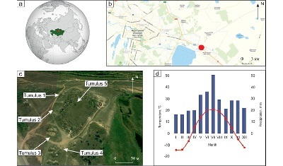 |
| Figure 1. Location of the Koy-Gunzhar burial ground: (a) overview map showing the study area, (b) location of site in Nur-Sultan city (c) structure of tumulus (Google image) and (d) climate diagram of the Nur-Sultan meteorological station showing monthly temperature and precipitation (Baisholanova, 2017). In the pictures a-b the study site is recommended to mark by black signs. |
- Materials and methods
2.1. REGIONAL SETTING
The climate of the studied area is dry and moderately continental. The average temperature in January is –14.5°С (Figure 1d); the mean snow cover is 153 days. The average temperature in July is +20.7°С. The mean annual temperature is estimated as +3.6°С; the sum of active temperatures (≥ 10°С) is 2252°С per year. The annual precipitation sum exceeds 322 mm; over the warm period (with temperatures above zero) precipitation sum reaches 222 mm, with a maximum in May–July. The moisture coefficient in the region, according to N.N. Ivanov, is 0.7–0.8 (Baisholanova, 2017). There are numerous inland and floodplain lakes in the vicinities of the studied site.
The vegetation of the location is represented by sheep fescue (Festuca ovina) and feather grass (Stipa spp.) steppes. Accumulation of mull humus and carbonates are key soil forming processes for this area. Haplic and Calcic Kastanozems predominate in the soil cover of the studied area, some of them are Sodic. Gleyic Kastanozems, Solonetzs and Solonchaks are common in lowlands with relatively close ground waters (Matusevich, 1960; Khebanovich, 2016).
The burial ground including the tumuli 1 and 3 are located at the absolute elevation of 360 m a.s.l., on the high 1st terrace, approximately 7 m above the contemporary water level in the Ishim River (during low-water seasons). (Figures 1a–1c). The area of the burial ground has a rather flat surface slightly inclined from the valley side towards the riverbed. The surface has no considerable visible depressions, so the presence of groundwater which could affect soils (and paleosols) here is hardly possible.
2.2. ARCHEOLOGICAL CONTEXT AND CHRONOLOGY
The western part of the tumulus 1 was investigated in 2005 (the eastern part was explored in 1999 by S.V. Voloshin). Two north to south-oriented transects were studied: one in the eastern part of the embankment, and another one in its western part. The transects allowed to study an internal stratigraphy of the embankment and a profile of the buried soil. A stone circle, 32 m in diameter, was discovered within the embankment at the peripheral part of the tumulus.
The ancient surface was cut during the construction of the mound. It was discovered at a depth of 1.8 m from the 0-mark (heights were measured in both mounds from a conditional zero located at the top of a mound).
Three stratigraphic layers were revealed. Layer 1: dark homogeneous clay loam (up to 1 m) (Figure 2-1c). It forms the basis of the central part of the mound, it is also recorded in the central and northern parts of the western cut. Layer 2 (Figure 2-1b): clay «masonry» formed from earthen blocks (up to 2 m). The layer is described throughout the mound. Layer 3 (Figure 2-1d): yellow clay loam (from 0.15 to 0.4 m). The layer was discovered in the northern and western parts of the mound. The central part of the embankment was disturbed by robbers. There were no burial artefacts found.
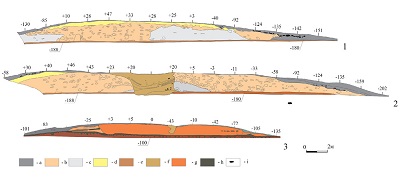 |
| Figure 2. Stratigraphy of tumulus. (1) tumulus 1, central cut; (2) tumulus 1, western cut; (3) tumulus 3, central cut. a) humus layer; b) «masonry» formed from earthen blocks; c) dark homogeneous clay loam; d) yellow clay loam; e) mainland layer; f) robbery pit; g) light brown loam; h) buried soil; i) stones. |
An embankment of the tumulus 3 was partially damaged during Muslim cemetery construction. Its structure was studied along a transect of the damaged section of the mound. The ancient surface is fixed at a depth of 1 m from the zero mark. The mound was built in two stages. First, a light brown loam was set on the levelled ancient surface (Figure 2-3g). The thickness of this layer was up to 0.4 m. Later, the formation of the humus horizon began on this layer. The mound was top–up supplemented during the construction of new graves.
No radiocarbon dates were provided for the tumulus 1. Meanwhile, the tumulus 2 (having similar construction and located in the vicinity) was radiocarbon dated by human bones (IMCES-14С1641 - 2586±85 yr BP, 901-461 cal BC (prob. 94.5%, IntCal 20). Thus, the construction of the burial mound can be attributed to VI-V BC (Tleugabulov and Gaisa, 2020), and the same dating might be supposed for the Тumulus 1.The time of the tumulus 3 construction is unknown because there are no burial equipment discovered and no dated analogues in the vicinities.
 |
| Figure 3. Tumulus embankments: morphology of the vertical sections (a. tumulus 1; b. tumulus 3) physical and chemical properties of the substrates composing embankments (n=5–7) (c. tumulus 1; d. tumulus 3). |
2.3. FIELD SOIL EXAMINATION METHODS
Morphology and genesis of the tumulus embankments and buried soils under the embankments were examined during field survey in accordance with the World Reference Base (WRB) for soil resources (IUSS Working Group WRB, 2015) and FAO Guidelines for Soil Description (FAO Guidelines for Soil Description, 2006). Soil color was assessed in air-dry soil samples according to Munsell soil color charts (Munsell Soil Color Charts, 2019).
Soil samples were taken as a continuous core every 5–10 cm considering soil genetic horizons. The samples from the mounds were collected from the layers, representing individual building elements / strata of the mound and clearly identified by morphology.
2.4. LABORATORY ANALYSES
Particle size distribution analysis for fine particles (< 2 mm) was performed by the conventional pipette method with sodium pyrophosphate pre-treatment (van Reeuwijk, 2002) to distinguish texture classes.
The following soil properties were determined: soil organic carbon (SOC) content by wet oxidation by potassium dichromate; pH in suspension (1:2.5) was measured potentiometrically; and calcium carbonate content was measured using a Bernard calcimeter in sealed vessels with rubber stoppers after treatment with 10% HCl solution (Vorobieva, 2006). Magnetic susceptibility was measured using the Kappabridge KLY-2 magnetic susceptibility system and expressed per 1 gram of soil (χ∙10-6 SI∙g-1).
To determine bulk chemical composition, an aliquot was fused with sodium carbonate. Phosphorus was measured spectrophotometrically with molybdenum blue and C6H8O6; iron was measured by the sulphosalicylate method, manganese was measured with formaldoxime, and silicon content was determined with gelatin gravimetry. Calcium, magnesium, and aluminium contents were determined by complexometry, whereas potassium and sodium were measured by flame photometry, and sulfur was measured by turbidimetry (Vorobieva, 2006).
2.5. MICROBIOMORPH ANALYSIS
The composition of the microbiomorphs (phytoliths, diatom algae, sponge spicules, coal microparticles, pollen, etc.) was studied in samples of tumulus embankments. The samples for this analysis were collected only from the embankment, because the upper part of the buried soil profiles was removed by the construction process, thus precluding the reconstruction of a plant formation that existed before the burial.
The collected samples were air-dried and subjected to standard procedures (Piperno, 1988). After treatment with hot 30% H2O2 solution and 10% HCl, an aliquot (approximately 50 g) was subjected to flotation in heavy liquid (cadmium iodide and potassium iodide solution with a specific gravity of approximately 2.3 g/ml). After centrifugation (1500 r·min-1 for 20 min), the floating phytoliths were collected in a tube, washed several times with distilled water, and studied by using an optical microscope at 300× magnification. Phytoliths were counted on the area of a cover glass (24 mm × 24 mm).
The phytoliths were identified according to ICPN 2.0 (International Committee for Phytolith Taxonomy, 2019).
- Results
3.1. TUMULUS EMBANKMENTS
3.1.1. MORPHOLOGY AND PHYSICOCHEMICAL PROPERTIES
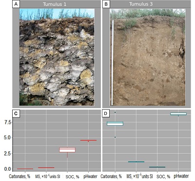
Tumulus 1 is 42 m in diameter and 2.2 m high. The humus layer of the original soil was partly truncated before the construction. The biggest part of the tumulus embankment is built of three types of materials different in morphology and composition: 1. dark homogenous loam (Figure 2-1c); 2. yellowish loam (Figure 2-1d); 3. earthen “masonry” composed of dark and yellowish blocks (chunks) (Figure 2-1b). Within the studied section, the embankment is composed of the earthwork (earth blocks, soil blocks). These are irregular lenses and blocks made of dark-colored loam 2.5 YR 3/1 dark reddish grey rich in organic carbon, often associated (within one block) with subjacent material having reductimorphic color (5 GY 6/1 greenish grey); 10 YR 6/8 bright yellowish brown loam with manganese (dark brownish) and iron (yellowish) concretions (Figure 3a).
The material inside the blocks is not mixed so that every single block preserves an original morphology of a soil horizon or a sequential pair of horizons. Blocks which contain more than one soil horizon have topsoil horizonation: humus layer on top, and horizon with redoximorphic colors below (gleyic properties). Blocks are sharp-bordered, those were not mixed and not compacted having open cracks in between. In a close view root and earthworm channels that start in the humus horizon, follow to the gleyic horizon of the same clod, but never to another clod. Imprints of the inner weaving of the baskets used to transport the substrate to the construction site were revealed in the material of the embankment.
Tumulus 3 is 32 m in diameter and 1 m high. The tumulus embankment has a simple arrangement. It is built mostly of a homogenous poorly humified calcareous sandy loam 5 YR 7/3 – 5 YR 5/1 dull orange–brownish grey (Figures 2-3g and 3b).
The physical and chemical properties of the tumulus embankment material reflect its different genesis. Materials of the embankment of the tumulus 1 contain no carbonates and 2,5 -3% of organic carbon, which is about 10 times more compared to one measured in the embankment of the tumulus 3. These are characterized by low pH (about 4.5), low magnetic susceptibility of about 0.2 ∙10-6 SI∙g-1 (Figure 3c), and loam and sandy loam texture (Figure 4).
Tumulus 3 had a low mean value of soil organic carbon content (less than 0.3%), alkaline reaction, as well rather high carbonate contents and magnetic susceptibility (exceeding 1) (Figure 3d). It has loamy sand and a sandy loam texture (Figure 4).
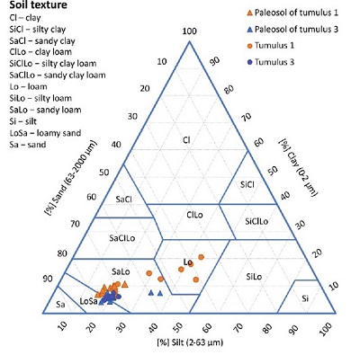 |
| Figure 4. Textural variability of paleosols and the tumulus embankments. |
3.1.2. MICROBIOMORPH ANALYSIS
The microbiomorph analysis of the tumulus 1 samples taken from the dark-gray and light-yellow blocks of the embankment revealed different assemblages. The samples of dark-gray material (n=3) contained many charcoal microparticles (Figure 5A), giving the samples dark color. The microbiomorph fraction is numerous and diverse. It includes in “shells” of diatoms, sponge spiculae and a variety of phytoliths (Figures 5B – 5L) Diatoms were rather big in size (20–50 μm) and very well preserved (Figure 5B). The forms, common for meadow phytocenosis dominate among phytoliths (Carinate lanceolate, Bulliform flabellate, Crenate) (Figures 5E, 5F, 5I and 5K). Phytoliths of steppe plants were not found.
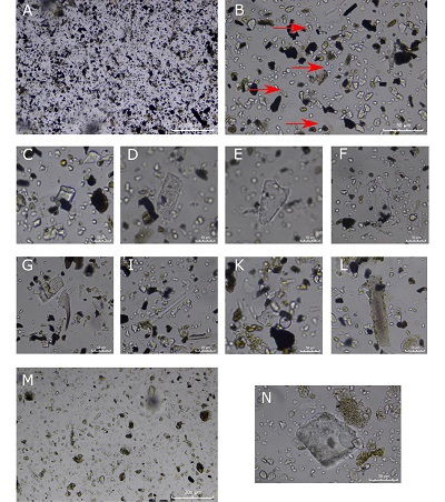 |
| Figure 5. Microbiomorph composition of the tumulus 1 embankment. The sample from the dark-colored blocks A – general view of the preparation (scaled 200 μ); B – microbiomorph diversity (scaled 50 μ). The arrows point at diatoms; Phytoliths diversity: C, D – Blocky forms; E – Carinate lanceolate forms; F – Bulliform flabellate forms (Phragmites sp.); G – Acute bulbous form; I, K – Crenate; L – Elongate sinuate forms; The sample from the mineral, yellow-colored block: M – general view of the preparation (scaled 200 μ); N – Blocky forms (Phragmites sp.). |
The light-yellow colored samples (n=3) contained practically no silicon microbiomorphs (Figure 5M), with the exception of a reed singleton (Figure 5N). Yellow samples were poor in amorphous organic matter and pollen compared with the dark-grey colored group of samples, (compare Figures 5A and 5M).
Samples of the material obtained from the tumulus 3 embankment were similar to the yellow-colored samples of the tumulus 1 as they also had amorphous organic matter clots and no silicon microbiomorphs.
3.2. BURIED SOILS
3.2.1. MORPHOLOGY, PHYSICOCHEMICAL PROPERTIES AND IDENTIFICATION
Paleosols buried under the tumuli 1 and 3 have some common features (especially in the lower part of the profiles) but those diverge considerably from each other both in morphology and analytical features in their upper part.
A paleosol buried under the tumulus 1 clearly differs in morphology, chemical and physical properties from the overlaying material of the embankment and have much in common with paleosol buried in the tumulus 3 and with the adjacent surface Kastanozems. The buried soil has the following sequence of horizons: *Ab(01 –20 cm) – Вw1b (20–32 cm) – Bw2b (32–36 cm) – Bkb (36-100 cm) and includes dark, and rich in humus Ab horizon and Protocalcic horizon rich in secondary carbonates (soft nodules and impregnations). The upper part of the humus horizon was cut in the process of construction, so that it is about half as thick as in the surface Kastanozems of the study area. Nevertheless, it is dark-colored (7.5 YR 4/3 brown) and has relatively high content of organic carbon about 0.8% (Figure 6). It could be attributed as Mollic horizon but pH values are extraordinarily low for steppe soils (less than 6), indicating that base saturation is low and does not fit the criteria for Mollic. This dark, rich in humus upper horizon with low base saturation must be considered as Umbric. Though Umbric normally is not combined with Protocalcic horizon.
*The depth is given from the buried surface.
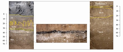 |
| Figure 6. Morphology of the buried soils. |
The upper part of the paleosol buried in the tumulus 1 (top 36 cm) has some specific morphological and analytical properties and does not comply WRB requirements for Kastanozems (IUSS Working Group WRB, 2015). There is Bw1b horizon having the intensive brown-reddish color (7.5 YR 5/6 bright brown), subangular blocky structure, and spongy texture below Ab horizon. The ped surfaces are covered by reddish-brown iron-manganese coatings. Bb horizon is followed by a very thin dark-colored (7.5 R 4/8 red) mineral Bw2b horizon highly enriched with manganese and iron (Figure 8) with very abrupt transition and weakly wavy boundary.
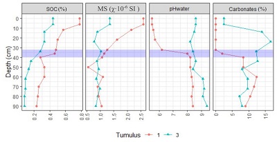 |
| Figure 7. Some physical and chemical properties of the paleosols. Blue lines show iron- and magnesium-manganese-aluminum-enriched horizon. Abbreviations: SOC – soil organic carbon; MS - magnetic susceptibility. |
Laboratory analyses show that SOC profile distribution has an accumulative character (Figure 7), while SOC content in the Ab horizon is below 0.8% and gradually decreases downwards to 0.2% in the Bkb horizon. The magnetic susceptibility of 2.14–2.59·10-6 SI∙g-1 was measured in the humus horizon, then it decreases, increasing at 50 cm to 1.09·10-6 SI∙g-1 and farther on with depth ranging 0.9–1.05·10-6 SI∙g-1 at the bottom.
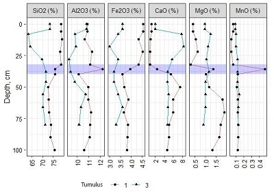 |
| Figure 8. Bulk chemical composition of paleosols buried under the tumulus embankments (% on the oven-dry basis). Blue lines show iron- and magnesium-manganese-aluminum-enriched Bwb horizon. |
The buried soil has pH ranging from acid to alkaline values. At the 36 cm depth pH drastically changes from 5.5 (which is extremely low for soils of dry steppes) to 8.0 at the transition to Bk horizon, ranging 8.0–8.4 below this depth (Figure 7). Carbonate content sharply increases in line with pH at 36 cm. The top part of the profile is carbonate-free and shows effervescence after adding 10% НСl solution at 32 cm depth and below. The content of CaCO3 in Bkb horizons varies between 7 and 12,5%, and its analytical maximum does not correspond to the visually detectable the lightest sub-horizon in the profile at the upper boundary of Bk horizon. It can be explained by partial diagenetic degradation of Protocalcic (Bkb) horizon in its upper part. This conclusion is supported by morphological observations. Secondary carbonates are mostly concentrated in Bkb within soft nodules. Besides that, the upper 10 cm of that horizon reveal uneven whitish calcareous impregnation which make this sub-horizon visually lighter colored. Calcareous nodules in this part of the horizon have diffuse boundaries; some of them look like diffuse spots testifying on their partial degrading.
Thus, classifying the paleosol buried in the tumulus 1 is problematic due to the diagenetic transformation of its upper horizons which will be discussed below. We suppose that originally this paleosol could be Haplic Kastanozem if to take into account its well-preserved Protocalcic horizon, dark-colored and rich in humus Ab horizon, morphology of the second paleosol buried in the tumulus 3, and morphology of adjacent surface soils. The upper horizons of this soil were transformed by diagenetic processes resulting in acidification, leaching of carbonates, redistribution and accumulation of Fe and Mn compounds. These processes caused a drop in base saturation in the upper Ab-Bw1b-Bw2b horizons, so that the former Mollic horizon shifted to Umbric and the soil shifted from Kastanozem to Umbrisol. Formally this paleosol with dark topsoil and low base status of the upper horizons meets the requirements for Mollic Cambic Umbrisols (Epiloamic, Katoarenic). Diagenesis produced a soil profile with contradictory features: acid, low base saturated upper horizons with an accumulation of Fe and Mn oxides; and Bk horizon rich in secondary carbonates, though calcareous pedofeatures degrades in its upper part.
A paleosol buried in the tumulus 3 (Figure 6) has 7.5 YR 5/1 brownish grey humus horizon and profile formula as follows Akb (0–6 cm) – Bk1b (6–24 cm) – Bk2b (24–90 cm). Field examination revealed that dark-colored, well-structured humus horizon was partly removed before burial (based on its sharp, and even upper boundary and inconsiderable thickness). The thickness of Akb horizon and the content of organic carbon (0.44%) is less than it is necessary to attribute it to Mollic (Figure 7), but the color is dark enough for Mollic. If to consider partial removal of the top horizon during the tumulus construction and diagenetic loss of organic carbon after more than 2500 years of burial, we can suppose it was Mollic before burial. The buried soil displayed well-developed Calcic horizon with CaCO3 content of more than 15% at 6–14 cm (Figure 7) and segregations of secondary carbonates. Laboratory analyses showed that paleosol was characterized by the gradual decrease of soil organic carbon content with depth (from 0.44 in Akb horizon to 0.09% in Bk2b). The SOC content correlated with magnetic susceptibility, the latter being 1.35·10-6 SI∙g-1 in the humus horizon and 0.84–0.99·10-6 SI∙g-1 in the lower part of the profile (Figure 6). Carbonates are present throughout the soil profile. The entire soil profile had alkaline рНH2O (8.6–9.0), it is high enough to suppose solonization process. We have no data on exchangeable Na and Mg but based on high pH it can be supposed that this soil is Protosodic.
Thus, the morphology and physicochemical properties of the paleosol allow the conclusion that the soil buried under the tumulus 3 was formed in the dry steppe environment. It was identified as Calcic Someric Kastanozem (Arenic, Protosodic).
3.2.2. BULK CHEMICAL COMPOSITION
The total content of chemical elements in the paleosol under the tumulus 1 revealed redistribution of elements related both to key soil-forming processes of buried soil (accumulation and redistribution of carbonates) and presumably to specific diagenetic processes. The profile was differentiated into two parts: the upper 0–32 cm and the lower 32–100 cm. The upper part recorded leaching of Ca and Mg along with an accumulation of Fe. In the 0–32 cm layer content of CaO was 1%, increasing downwards in the Bkb horizon up to 4–6%. Magnesium was accumulated at the depth of 50–80 cm, reaching 1.6–1.8%. The Bw2b horizon at the 32–36 depth revealed a sharp increase in contents of Аl2O3 and MnO.
The total contents of chemical elements in the paleosol under the tumulus 3 are rather evenly distributed along the profile (Figure 8). Silicon oxide content ranges between 63 and71%, aluminum oxide makes 10–11%, and iron oxide is 3.3–3.6%. Manganese (0.10–0.14%) and magnesium (1.0–1.2%) oxides also display rather even distribution patterns along the soil profile. Maximal total CaO content of 7–8% was found in the Bk horizon (Figure 8) which is explained by pedogenic accumulation of CaCO3.
- Discussion
4.1. THE SOURCE OF SUBSTRATES TO CONSTRUCT THE TUMULUS EMBANKMENTS, AND CONSTRUCTION TECHNOLOGIES
The data on morphology, physio-chemical properties, and composition of biomorphs obtained for materials of tumulus embankments testify on different sources of building materials and different building technologies applied for construction of the tumulus 1 and the tumulus 3.
The tumulus 1 was built of the none homogenized material: earthen blocks obtained from different soil genetic horizons. A similar technique of the earthen “masonry” composed of none-mixed soil materials was earlier reported in Zhdanovich et al., 1984; Aleksandrovskiy and Alexandrovskaya, 2005; Plekhanov and, Demkin, 2005; Borisov et al., 2019) for different times and regions.
Key characteristics of materials used for the embankment of the tumulus 1 are as follows: 1. all morphological variety of materials have redoximorphic features (reductimorphic or oximorphic colors, Fe-Mn segregations in oxidized material); 2. low magnetic susceptibility of the tumulus substrate complies with the hydromorphic conditions of soil formation since such conditions favor the breakdown of minerals capable to magnetize; 3. dark-colored rich in organic carbon material of the embankment contains indicators of wetlands: shells of diatoms, sponge spicules, phytoliths of meadow plants; 4. all the materials are carbonate-free, and have pH values about 4.5. As based on morphological characteristics, low magnetic susceptibility, high content of organic carbon in blocks of humus horizon, and composition of biomorphs, the material of waterlogged soils was applied to construct the tumulus 1 embankment. The lack of carbonates and especially low pH are unusual for soils of arid environments and particularly for waterlogged soils of the studied area which are nearly always base saturated, and rich in carbonates in all horizons. It is obvious that after the embankment was constructed the material of waterlogged soils lost its connection with ground waters and ran dry. It is known that waterlogged soils when drained change their redox statues: those are oxidized, Fe2+ is converted to Fe3+ which is partly transformed into aqua-complexes as follows: Fe(H2O)63+ + H2O → Fe(H2O)5(OH)2+ + H3O+, or Fe3+ + H2O → Fe(OH)2+ + H+. Thus Fe2+ to Fe3+ transition followed by rewetting produces protons and results in some drop in pH (Vorobieva, 2016; Vodyanitskij, 2017). But it is hardly possible that related acidification may result in the decrease of pH up to 4.5 and the leaching of carbonates. We consider the only possible explanation of the above-described combination of properties to be related to the presence of sulfides. Supposedly the embankment of the tumulus 1 was raised of waterlogged soils containing sulfidic materials. Such soils are known as potential acid sulfate soils. Those when drained and rewetted become acid due to the oxidation of inorganic sulfidic compounds and produce acid drainage water (IUSS Working Group WRB, 2015, Jacobs et al., 2014). pH can drop considerably (up to 3.5), but carbonate-containing soils have self-neutralizing capacity so that pH decreases not so critically. This hypothesis needs to be supported by an assumption concerning a possible source of sulfidic materials and sulfide-containing soils in the landscape under investigation.
Sediments of sulfate lakes in an arid climate are known for the accumulation of sulfides through the reduction of sulfate from lake water (Kasimov et al., 2016). The same process was described earlier for the coastal environments and tidal marsh soils as sulfurization (Fanning and Fanning, 1989; Fanning et al., 2002).
The studied area is known for numerous inland and oxbow lakes: Maybalyk, Taldykol, Kyzylsuat, Tanakol’ and many smaller others. Some of them are in close vicinity to the studied site (Figure 1b and 1с). Hydrological characteristics of the largest lake Maybalyk reveal a high level of salinization and predominance of chlorides and sulphates in waters with the high content of the last ones: 285.6 mg/l (Akbayeva et al., 2018). Even waters of the Ishim River near Nur-Sultan have rather high mineralization: up to 1300 mg/l, and high content of sulphates: up to 230 mg/l during low water seasons (Uryvaev, 1958). Sulphides occur in soils of floodplain wetlands in river valleys of Kazakhstans (Durasov and Tazybekov, 1981). Waterlogged soils containing sulfidic material of inland lakesides or floodplain wetlands could be a potential source of building material for the tumulus 1. Gypsum accumulation in the embankment (detected analytically or micromorphologocally) could be a trace of former sulfidic materials. But for now, we do not have any data on gypsum, so the question needs to be further investigated.
The imprints of the basket weaving, found in the mound substrate, implied that the mound was constructed with material that was either naturally saturated with water or purposefully saturated by man. Water saturation of the embankment and especially the presence of easily oxidizable sulfides also might lead to a drastic geochemical shift in the environment of the soil that was buried under the mound: the gravitational water flow might change pH i.e. conditions for intra-soil migration and accumulation of Fe, Mn, AL, Ca, and Mg , especially in the upper part of the buried soil.
The certain similarity in the physic-chemical properties of the tumulus 3 mound and the paleosol beneath it strongly suggested that the mound was built with a mixture of the humus (Akb) and transitional (Akb/Bk) horizons collected from the adjacent area (compare Figures 3,4,6 and 7).
A question concerning building materials for the tumulus 3 is simply solved. Based on the texture, color and analytical characteristics (pH, contents of carbonates), the tumulus 3 embankment was built of the mixed soil materials (different genetic horizons) of surrounding Kastanozems.
4.2. DIAGENESIS OF PALEOSOLS
Every landscape has its specific composition of chemical elements corresponding to its geochemical nature. Chemical elements, having high mobility and accumulating in a landscape, are referred to as typomorphic. In steppe landscapes and their components (biota, soil, etc.) Ca, or Ca and Na, are key typomorphic elements which tend to accumulate in landscapes and soils. such elements as Fe, Al, and Mn usually have low migration and accumulation potential even in neutral or alkaline hard groundwaters affected steppe landscapes (Perelman and Kasimov, 1999).
According to the results of our study of soil morphology, physicochemical properties and total chemical elements contents, the tumulus 3 paleosol was formed in a dry steppe landscape. This soil was poorly transformed by diagenesis (except for some diagenetic loss of organic carbon) since after its burial the soil was in the geochemical environment rather similar to one of its originations.
The tumulus 1 paleosol also was originally formed in dry steppe conditions, but only the lower part of its Protocalcic (Bkb) horizon stayed slightly touched by diagenetic processes. The above-described clear differentiation of the profile in two (upper and lower) parts resulted from the drastic shift in the geochemical conditions after the soil was buried under the tumulus embankment. The upper part of the buried profile reveals acid pH, no carbonates, rise in magnetic susceptibility with morphologically and analytically detectable accumulation of iron oxides. An abrupt upper contact of the Bk horizon is remarkable by the sharp increase in contents of Аl2O3 and MnO. All these features can be explained by diagenetic transformations of upper buried horizons due to the infiltration of acid solutions from the embankment. Acid drainage is supposedly related to oxidation of sulfidic material which was originally contained in waterlogged soils and applied as the material for the embankment construction.
Calcium and magnesium carbonates readily dissolved and migrated as ions in acidic environments. This led to the leaching of carbonates from the upper part of the buried soil and partial degrading of the upper part of Bk horizon. Iron, manganese, and aluminium being mobilized from the embankment and upper buried horizons accumulated over a geochemical interface of Bk horizon due to a sharp pH change. This hypothesis seems to be rather consistent with the only exception of restricted water supply for rewetting the 2 meters thick embankment and gravitational percolation of acid solutions into the buried soils. Only atmospheric precipitation in an arid climate is hardly enough for the deep transformation of the material of the embankment and underlying buried soil (oxidation of sulfides, dissolution and leaching of Ca and Mg carbonates, migration and accumulation of Fe, Al and Mn over the Bk horizon. This may imply possible anthropogenic rewetting of the embankment for some ritual or practical reasons.
The tumulus construction technique which supposes watering the embankment material was described in the southern part of the Jutland Peninsula in Denmark. Currently, there are more than 20 tumuli (14th century BC) which have mounds with Fe-Mn pans that ensured good preservation of organic artifacts, for example, Egtved Storhøj. Based on the soil geochemical investigation of the ferrous-manganese layers and some experimental work, a hypothesis of the genesis of such layers was proposed (Holst et al., 1998; Breuning-Madsen et al., 2000, 2001). Cemented Fe-Mn pen formation was reproduced experimentally by the creation of anaerobic conditions in the core of the mound. A basement of an embankment was constructed of soaked with water and trampled sod layers. Due to oxygen depletion as a result of the decomposition of organic matter within the anaerobic area, Fe and Mn were reduced within the created anaerobic core, migrated and accumulated due to oxidation within aerobic zones.
We could suppose similar mechanisms of redoximorphic transformation of the soil buried in the tumulus 1. But it wouldn’t be easy to support an anaerobic zone and the reduced conditions within the embankment built of incoherent earthen blocks even if those were originally soaked with water (if to take into account the arid climate where water evaporates fast. In addition, we find signs of former reduction processes only within the earthen blocks of the embankment but not within the buried soil itself. So that diagenetic processes formed Fe-Mn enriched layers in the tumulus 1 might be different from those described for the Bronze Age burial mounds in Denmark and possibly related to anthropogenic rewetting of the mound and acid drainage from sulfide-contained material of the embankment.
So far, the use of rewetting of tumulus mounds and mound construction from waterlogged soil materials by Scythian tribes were not reported. Therefore, the tumulus 1 mound provides an excellent example of a unique experiment performed by ancient builders, which most likely was based on their religious beliefs.
To construct the mound, the tumulus 1 builders used a loamier substrate, ensuring the robustness of the construction and differing from the soil material in the adjacent areas, where it was mostly loamy sand or sand. The expenses to design the mound, find the appropriate construction material and arrange its transportation altogether underscore the careful planning of the construction. Implementation of the such project required organized collective efforts to move the substrate and construct the mound. Besides that, such an uncommon construction process (with the planned-in-advance mound properties, in an environment where the needed construction material was scarce) strongly implicates the role of builders’ cultural choice, which, in its turn, allows to conclude about the special significance of the choice of the site to create burial grounds for the Scythian-Sak elite. The tumulus 3 mound was constructed employing the technique that was the most common for mound construction in the Eurasian steppes, i.e. using as a construction material the mixed material of the surrounding Kastanozems. Although the technique is rather often reported in archaeological literature (Bajenov et al., 2013; Khabdulina, 2019), the geoarchaeological studies of such objects are rather few (Borisov et al., 2019; Khokhlova and Nagler, 2020).
- Conclusion
The combined study of tsar tumuli of the Koy-Gunzhar burial ground and buried paleosols allowed reconstructing mound building techniques and determining the effect of changed geochemical conditions on the paleosols diagenesis.
The Scythian elite tumuli were built using various construction methods and different building materials. Mixed material of surrounding well-drained soils (Kastanozems) was applied for the tumulus 3 construction. Buried soil under the tumulus 3 does not demonstrate any considerable diagenetic transformations.
The material for the tumulus 1 construction was transported from the waterlogged landscapes (supposedly from the neighbouring river floodplains). The main part of its embankment was constructed of incoherent earthen blocks cut from different horizons of waterlogged soils which supposedly contained sulfidic material. Oxidation of sulfides and acid drainage (possibly stimulated by anthropogenic rewetting) might result in a sharp pH decrease, decalcification of the embankments and the upper horizons of the buried soil, Fe, Mn, and Al accumulation over the upper boundary of degrading Bk horizon.
Thus, we conclude that the elite Scythian-Saks tumuli were not simple ground mounds, but rather complicated and fundamental archaeological monuments, significant from the point of view of their builders.
Authors’ contribution
Gavrilov Denis A., Khabdulina Maral K. designed methodology, performed data acquisition and analyses, visualization, and interpretation, as well as wrote the manuscript draft; Sviridov Alexey N. carried out the fieldwork and final manuscript editing; Bronnikova Maria A. – final editing and reworking of the text.
Financial support
This research was funded by the Science Committee of the Ministry of Education and Science of the Republic of Kazakhstan (Grant No. AP09261134) and the Ministry of Science and Higher Education of the Russian Federation (project No. 121031700316-9). Theoretical developments of this study were partly funded by State assignment FMGE-2019-0006 (Institute of Geography, RAS).
Conflict of interest
The authors declare no conflict of interest between institutions, or other third parties with respect to the entire content of the article or its parts.
Editorial disclaimer
The prolonged time span between submission and acceptance (one year) is by no means attributable to the editorial performance of the journal or handling editors, but to the most regrettable fact that the main author of this paper is a casualty of the COVID pandemics, and to the difficulties of the remaining authors at accessing his archives when in need of correcting the manuscript. May he rest in peace.
References
Akbayeva, L.Kh., Mursalimova, M.R., Tulegenov, E.A., Yuzhalkin, D.S., Kolesnik, E.V., 2018, Hydrochemical characteristics and species composition of plankton in the Lake Maybalyk in the Vicinity of Astana City, Republic of Kazakhstan: Bulletin of the South Ural State University. Ser. Chemistry, 10(3), 16–23. http://dx.doi.org/10.14529/chem180302
Akishev, K.A., 1978, The issyk mound. The art of the Sakas of Kazakhstan: Moscow, Iskusstvo, 132 р.
Akishev, К.А., Kushaev, G.A., 1963, The ancient culture of the Saks and Usuns of the Ili River valley: Alma-Ata, Akademiya Nauk KazSSR, 320 p.
Aleksandrovsky, A.L., Khokhlova, O.S.,Sedov, S.N., 2004, Bolshoy Ipatovsky Kurgan as considered by the specialists in Soil Science: Russian Archaeology, 2, 61–70.
Alexandrovsky, A.L., Alexandrovskaya, E.I., 2005, Evolution of soils and geographical environment: Institute of Geography of the Russian Academy of Sciences Moscow, Nauka, 223 p.
Baisholanova, S.S., 2017, Agroclimatic resources of the Akmola Region: a scientific and applied reference: Astana, Institute Geografii, 133p.
Bajenov, A., Safarova, L., Yakimov, A., Tairov, A. 2013, “Brick - Cement” - universal system for construction of kurgans, in Tairov, A.D., Ivanova, N.O. (eds.), Ethnic interactions in the Southern Ural: Chelyabinsk, Rifei, 251-257.
Beisenov, A.Z., Duisenbay, D., Akhiyarov, I., Sargizova, G., 2016, Dromos Burials of Tasmola culture in Central Kazakhstan: The Anthropologist, 26 (1–2), 25–33. https://doi.org/10.1080/09720073.2016.11892125
Beisenov, A.Z. 2016a, Monuments of the early stage of Tasmola culture: Tomsk State University Journal of History, 1 (39), 119-126.
Borisov, A.V., Krivosheev, M.V., Mimokhod, R.A., El’tsov, M.V., 2019, “Sod Blocks” in Kurgan Mounds: Historical and Soil Features of the Technique of Tumuli Erection: Journal of Archaeological Science: Reports, 24, 122–131. https://doi.org/10.1016/j.jasrep.2019.01.005
Breuning-Madsen, H., Holst, M.K., Rasmussen, M., 2001, The chemical environment in a burial mound shortly after construction - an archaeological–pedological experiment: Journal of Archaeological Science, 28 (7), 691–97. https://doi.org/10.1006/jasc.1999.0570
Breuning-Madsen, H., Rønsbo, J., Holst, M.K., 2000, comparison of the composition of iron pans in Danish Burial Mounds with bog iron and spodic material: Catena, 39 (1), 1–9. https://doi.org/10.1016/S0341-8162(99)00083-1
Chugunov, K.V., Parzinger, G., Nagler, A., 2017, The royal mound of the Scythian time Arzhan-2, in Khansen, A., Molodin, V. I., (eds.), Tuva: Novosibirsk, IAE SB, 500p.
Durasov, A.M., Tazabekov, T.T., 1981, Soils of Kazakhstan: Alma-Ata, Kaynar, 152p
Fanning, D.S., Fanning, M.C.B., 1989, Soil: morphology, genesis, and classification: New York, Wiley, 416p.
Fanning, D.F., 2002, Acid sulfate soils, in Lal, R., (ed.), Encyclopedia of soil science: New York, Marcel Dekker, 1-5.
FAO, 2006, Guidelines for soil description, fourth ed.: Rome, Food and Agriculture Organization of the United Nations, 109p.
Gkouma, M., Karkanas, P., Iacovou, M., 2021, A geoarchaeological study of the construction of the Laona tumulus at Palaepaphos, Cyprus: Geoarchaeology, 36, 601–616. https://doi.org/10.1002/gea.21850
Gryaznov, M.P., 1961, Kurgan as an architectural monument: Abstracts of reports at meetings devoted to the results of field research in 1960: Moscow, Leningrad, 22-25.
Gryaznov, M.P., 1980, Arzhan, Royal mound early Scythian time: Leningrad, Nauka, 64 p.
Holst, M.K., Breuning-Madsen, H., Olsson, M., 1998, Soil forming processes in and below a Bronze Age burial mound at Lejrskov, Southern Jutland: Geografisk Tidsskrift-Danish Journal of Geography, 98(1), 46–55. https://doi.org/10.1080/00167223.1998.10649410
Hildebrandt-Radke, I., Makarowicz, P., Matviishyna, Zh N., Parkhomenko, A., Lysenko, S.D., Kochkin, I.T., 2019, Late Neolithic and Middle Bronze Age barrows in Bukivna, Western Ukraine as a source to understand soil evolution and its environmental significance: Journal of Archaeological Science, 27, 101972. https://doi.org/10.1016/j.jasrep.2019.101972
International Committee for Phytolith Taxonomy (ICPT), 2019, International Code for Phytolith Nomenclature (ICPN) 2.0: Annals of Botany, 124(2), 189–99. https://doi.org/10.1093/aob/mcz064
IUSS Working Group WRB, 2015, World Reference Base for Soil Resources 2014, update 2015 International soil classification system for naming soils and creating legends for soil maps. World Soil Resources Reports No. 106: Rome, FAO.
Jacobs, J.A., Lehr, J.H., Testa, S.M., 2014, Acid mine drainage, rock drainage, and acid sulfate soils: Causes, assessment, prediction, prevention, and remediation, first ed.: USA, John Wiley & Sons, 485p. https://doi.org/10.1002/9781118749197
Kasimov, N.S., Kasatenkova, M.S., Tkachenko, A.N., Lychagin, M.Yu., 2016, Kroonenberg S.B. Geochemistry of lacustrin-marsh and deltha landscapes of Pre-Caspian. 100 years universary of A.I. Perel’man: Moscow, Liga-Vent, 244p. (in Russian)
Khabdulina, M., 2016, Temples-sanctuaries of the Saka era of Northern Kazakhstan, in Religion and worldview system ancient and medieval nomads of Eurasia: Nomads and Sedentary Societies in Medieval Eurasi, Almaty, 137-148.
Khabdulina, M., 2019, New data on the study of the Tasmola archaeologial culture of Saryarka: Turkic Studies Journal, 1(2), 21-33. https://doi.org/10.32523/tsj.02-2019/2
Khokhlova, O.S., Nagler, A.O., 2020, The Marfa Kurgan in the Stavropol territory: An example of an ancient architectural structure: Archaeology, Ethnology and Anthropology of Eurasia (Russian-Language), 48(2), 38–48. https://doi.org/10.17746/1563-0102.2020.48.2.038-048
Khokhlova, O.S. Kuptsova, L., 2019, Complex pedological analysis of paleosols buried under Kurgans as a basis for periodization of the Timber-Grave archaeological culture in the Southern Cis-Ural, Russia: Quaternary International, 502, 181–96. https://doi.org/10.1016/j.quaint.2018.02.027
Klebanovich, N.V., 2016, Soils and land resources of Kazakhstan: Minsk, BGU, 46p. (in Russian)
Makeev, A., Rusakov, A., Kurbanova, F., Khokhlova, O., Kust, P., Lebedeva, M., Milanovskiy, E., Egli, M., Denisova, E., Aseyeva, E., Rusakova, E., Mihailov, E., 2021, Soils at archaeological monuments of the Bronze Age – A key to the Holocene landscape dynamics in the broadleaf forest area of the Russian Plain: Quaternary International, 590, 26–47. https://doi.org/10.1016/j.quaint.2020.09.015
Marsadolov, L.S., 2010, Big Salbyk Kurgan in Khakassia: Abakan, Kakasskoe Knizhooe Izdatelstvo, 128 p.
Matusevich, S.P., 1960, Akmolinskaya region, in Proceedings of Soil Science Institute of Kazakh Republic, Vol. 10: General landscape and soil conditions for agricultural production in different regions of Kazakhstan: Astana, 5-14. (in Russian)
Mozolevski, B., 1983, Scythian steppe: Kiev, Naukova Dumka, 197 p.
Munsell Color, 2009, Munsell Soil-Color charts with genuine Munsell color chips: USA, Munsell, 68p.
Nurzhanov, A.A., Jumabekova, G.S., Bazarbayeva, G.A., 2020, New datas on the Saka culture of Jetysu: brief results from the field research of 2020 around Almaty: Kazakhstan Archeology, 4(10), 69–95.
Ongar, A., Samashev, Z., Kiyasbek, G., Khasenova, B., Mamedov, A., 2013, Study of the area around the kurgan of mound 1 of the Tortoba burial ground, in Proceedings of the branch of the Institute of Archeology named by O.Kh. Margulan in Astana, Vol. II: Astana, Publishing group FIA, 24-131.
Ongaruly, A., Pen Enxvan, Nam Sanvon, Kairmagambetov, A., 2020, Katartobe: the necropolis of the Saka elite Zhetysu: a joint study of the Republic of Kazakhstan and the Republic of Korea: Nur-Sultan,Tedjon, 465 p.
Parzinger, G., Zaibert, V. F., Nagler, A., Pleshakov, A.A., 2003, Der große Kurgan on Bajkara: Studien zu einem skythischen Heiligtum: Mainz am Rhein, Verlag Philipp von Zabern, 280 p.
Perelman, А., Kasimov, N., 1999, Landscape geochemistry: Moscow, Moscow State University, 610 p.
Piperno, D.R., 1988, Phytolith analysis: An archaeological and geological perspective: San Diego, Academic Press, 280 p.
Plekhanova, N., Demkin, V.A., 2005, Ancient soil disturbances in River Valleys within the Steppe Zone of the Southeastern Urals L.: Eurasian Soil Science, 38(9), 973–982.
Sverchkova, A. E., Khokhlova, O.S., Kalmykov, A.A., 2020, Variations in the properties of chernozems and paleoenvironmental conditions in the North Caucasus in the 4th Millennium BC according to the results of the study of Essentuksky 1 Kurgan: Eurasian Soil Science, 53 (12), 1687–1700. https://doi.org/10.1134/S1064229320120121
Sviridov, A.N., 2006, Exploration of the burial mound in the Koy-Gunzhar tract: Astana, Archive of the Scientific Research Institute of Archeology, 48p.
Sviridov, A., Yarygin, S., Sakenov, S, 2014, Elite burial mounds of Akmola region: Dialogue of the cultures of Eurasia in the archeology of Kazakhstan: Astana, Sary-Arka, 596p.
Tleugabulov, D., Gaisa, A., 2020, Exploration of an elite burial mound of the early Iron Age in the Kuigenzhar tract: Nur-Sultan, Rim, Sacral landscape of Saryarka, 135p.
Toleubaev, A.T., 2018, Early saks Shilikta culture: Almaty, Sadvakasov A.K., 528 p.
Van Reeuwijk, L. P., 2002, Procedures for soil analysis, 6th ed.: Wageningen, International Soil Reference and Information Centre FAO, 119 p.
Uryvaev, V.A., 1958, Surface water resources for virgin and fallow land reclamation. Akmola region of the Kazakh SSR: Leningrad, 789p.
Vodyanitskij, Y.N., 2017, Iron in hydromorphique soils: Мoscow, Moscow State University, 160p.
Vorobieva, L.A., 2006, Theory and practice chemical analysis of soils: Moscow, GEOS, 400p.
Yuminov, A.M., Zdanovich, G.B., Zdanovich, D.G., 2017, Mineralogy and physical properties of soil blocks of the Great Sintashta kurgan (southern Urals): Geoarchaeology and Archeological Mineralogy, 4, 87–92.
Zdanovich, G. B., Ivanov, I.V., Khabdulina, M. K., 1984, Experience of using natural research methods in archeology (Kara-Oba and Obala burial mounds in Northern Kazakhstan): Soviet Archeology, 4, 35–48.
Peer Reviewing under the responsibility of Universidad Nacional Autónoma de México.
This is an open access article under the CC BY-NC-SA license(https://creativecommons.org/licenses/by-nc-sa/4.0/)