
|
Boletín de la Sociedad Geológica Mexicana Volumen 74, núm. 3, A040422, 2022 http://dx.doi.org/10.18268/BSGM2022v74n3a040422
|
 |
Identification of materials used for earthwork construction: the semi-circular fortification rampart of Hedeby, Northern Germany
Identificación de materiales de terraplenado: la muralla de fortificación semicircular de Hedeby, norte de Alemania
Anastasiia Kurgaeva1,*, Svetlana Khamnueva-Wendt2, Hans-Rudolf Bork2
1 Institute of Environmental and Agricultural Biology (X-BIO), Tyumen State University, Tyumen, 625003, Russia.
2 Institute for Ecosystem Research, Christian-Albrechts-University Kiel, Kiel, D-24118, Germany.
* Corresponding author: (A. Kurgaeva) This email address is being protected from spambots. You need JavaScript enabled to view it.
How to cite this article:
Kurgaeva, A., Khamnueva-Wendt, S., Bork, H.R., 2022, Identification of materials used for earthwork construction: the semi-circular fortification rampart of Hedeby, Northern Germany: Boletín de la Sociedad Geológica Mexicana, 74 (3), A040422. http://dx.doi.org/10.18268/BSGM2022v74n3a040422
Manuscript received: October 31, 2021; Corrected manuscript received: March 10, 2022; Manuscript accepted: March 28, 2022.
ABSTRACT
The protected status of archaeological sites requires using minimally invasive methods of material investigation such as coring. In contrast to excavations, the coring method does not present a complete view of the inner structure, and the limited amount of material in cores represents a small portion of the study object. This complicates the interpretation of material genesis. This problem is particularly relevant for complex structures such as earthworks. Nonetheless, the proper interpretation of the construction materials in earthworks is crucial for geoarchaeological investigations of the anthropogenic transformation of landscapes. We proposed a method for classifying and identifying the earthwork materials, sampled by the coring technique. It was developed using an example of the semi-circular fortification rampart around the former Viking settlement Hedeby, which was an important early medieval international trading center and today is a UNESCO world heritage site. Materials from the coring transect across the semi-circular rampart were described. The physicochemical properties of 139 samples from three cores were determined: grain size distribution, weight percentages of gravel, artefacts, bones, and charcoal, loss on ignition, magnetic susceptibility, and element concentrations. The statistical methods (normalization, correlation, standardization, principal component analysis, cluster analysis) were applied to distinguish and group materials according to their physicochemical properties. The resulting clusters were used as a basis for material classification. Some clusters were mildly transformed according to the morphological properties of the material. Consequently, 20 groups were distinguished based on the physicochemical and morphological properties of the material. The rampart was constructed from soil horizons, cultural deposits, and Pleistocene material, which were used in different proportions along the investigated transect. In addition, the constituents of mixed layers were identified. Overall, the presented method for the statistical classification of the material considerably facilitates and objectifies the identification of material genesis. This is particularly valuable in tackling the challenges of coring-based investigations of earthworks.
Keywords: material classification, earthwork, Hedeby, physicochemical analysis, multivariate statistics.
RESUMEN
La protección de los sitios arqueológicos se requiere de métodos mínimamente invasivos, como la extracción de muestras, durante los procesos de investigación de materiales. A diferencia de la visión obtenida en las excavaciones arqueológicas extensivas, los sondeos aportan un punto de vista parcial ya que únicamente son representativos de una parte pequeña del material y objeto de estudio. Esto complica la interpretación de la génesis material. El problema es especialmente significativo cuando se trata de estructuras complejas como las construcciones en tierra. Sin embargo, una interpretación adecuada de los materiales constructivos en tierra es determinante en cualquier tipo de investigación geoarqueológica relacionada con la transformación antrópica de los paisajes. Para la clasificación e identificación de los materiales se propuso un método siguiendo la técnica de extracción de núcleos. Esta fue aplicada en una zona de la muralla de fortificación alrededor del antiguo asentamiento vikingo de Hedeby, un importante centro de comercio internacional y hoy en día Patrimonio de la Humanidad por la UNESCO. Se describieron los materiales del transecto de núcleos extraídos a través de la muralla. Se determinaron las propiedades fisicoquímicas de 139 muestras de tres núcleos: distribución del tamaño de grano; porcentajes en peso de gravas, artefactos, huesos y carbón; pérdida por ignición, susceptibilidad magnética y concentración de elementos. Se aplicaron métodos estadísticos (normalización, correlación, estandarización, análisis de componentes principales, análisis de conglomerados) para distinguir y agrupar materiales según sus propiedades fisicoquímicas. Los grupos resultantes se utilizaron como base para la clasificación de materiales; algunos grupos se transformaron levemente de acuerdo con las propiedades morfológicas. En consecuencia, se distinguieron 20 grupos en función de las propiedades fisicoquímicas y morfológicas del material. La muralla fue construida a partir de horizontes de suelo, depósitos culturales, materiales del Pleistoceno, que se utilizaron en diferentes proporciones a lo largo del transecto investigado. Además, se identificaron los constituyentes de las capas mixtas. En general, el método para la clasificación estadística del material facilita considerable y objetivamente la identificación de la génesis del material, lo que es valioso para abordar los desafíos en las investigaciones de arquitectura de tierra basadas en la extracción de núcleos.
Palabras clave: clasificación de materiales, arquitectura de tierra, Hedeby, análisis fisicoquímico, estadística multivariada.
- Introduction
Earthen fortification ramparts are often prominent features of cultural landscapes. These complex human-made structures reflect the socio-geographical situation of the time of their construction. Their study allows deducing not only the advances of the engineering knowledge but also the economic, political, and cultural characteristics of the society responsible for their formation (e.g. Sherwood and Kidder, 2011; Nadel et al., 2013; Ortmann and Kidder, 2013; Croix et al., 2019). In general, earthen ramparts often carried the main function of settlement protection, thus, their stability and size were crucial parameters. Such earthworks required detailed planning, efforts for the site preparation, understanding of soil properties, and engineering skills (Sherwood and Kidder, 2011).
The materials, which constitute the earthwork, reflect the landscape properties surrounding it as usually the materials, which were readily available in the settlement and namely its vicinity, were used for the construction (e.g. Sherwood and Kidder, 2011; Lang, 2012; Nadel et al., 2013; Bel’skiy, 2019; Croix et al., 2019). The exact identification of the earthwork materials is a crucial step in understanding the techniques used and the scale of the landscape transformation during construction. The material identification and correct classification enable placing the earthwork into the context of the anthropogenically transformed landscape around an archaeological site. However, there were no studies dedicated to this problem. The identification of the translocated and often mixed material is a complicated task. Moreover, the high heterogeneity of the earthwork structure due to its entirely anthropogenic origin makes this task even more challenging.
Excavation transects through an earthworks often provide the best overview of the structure and used materials, which enables the reconstruction of the formation processes (e.g. Jankuhn, 1937; Tummuscheit and Witte, 2019). However, it leads to a significant disturbance and often destruction of an object under study. To preserve the earthwork, less destructive methods such as corings are used sometimes (e.g. Herrmann et al., 2014; Laermanns et al., 2018). Nonetheless, the use of this method of investigation further complicates the task because the comprehensive observation of the layers with its properties and its interrelations is limited (Ibsen, 2018). For this reason, it is important to perform multiple corings along transects and detailed physicochemical analysis of the core materials. With the help of statistical methods, an objective classification of materials can be developed. A similar approach was proposed for settlement deposits (Khamnueva-Wendt et al., 2020); however, it would require certain modifications for the study of an earthwork because of its complexity and entirely anthropogenic origin.
Therefore, this research aims to develop an approach for the classification and identification of materials of highly heterogeneous and anthropogenic structures such as earthworks. The use of physicochemical parameters together with multivariate statistical methods and later adjustment of the resulting clusters according to the morphological properties would allow to objectively separate the numerous materials into groups and identify their sources. This approach is developed using the example of the semi-circular fortification rampart around the former Viking settlement Hedeby.
- Study site
The study area is located at the former Viking settlement Hedeby (German: Haithabu) at the western shore of Haddebyer Noor and approximately 40 km northwest of the city of Kiel, Schleswig-Holstein, Germany (Figure 1). The geographical coordinates of the study area are 54°29′ 28″ N and 9°33′ 55″ E. The elevation inside of the settlement ranges from 0 m a.s.l. at the eastern margin up to 15 m a.s.l at the western edge in the vicinity of the semi-circular rampart, which has its maximum elevation of around 21 m a.s.l at the south-western section. The western section of the rampart is the highest and its height decreases towards its edges at the shoreline. A small brook crosses the semi-circular rampart at its western margin and divides the former settlement almost in halves.
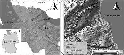 |
| Figure 1. Location of the study area (based on Khamnueva-Wendt et al., 2020: 315, Figure 1). |
The study area and its surroundings were affected by several glaciations during mid and late Pleistocene. Thus, the area is characterised by diverse quaternary sediments dominated by fluvio-glacial sands and glacial till deposits, which are the parent material for soils within the study area (Koster, 2005; Stephan, 2014). Sandy to loamy till deposits are usually covered by fluvio-glacial well-sorted sand material. Locally, varved lacustrine sediments of proglacial lakes are found under the fluvio-glacial sands (Geologischer Dienst Schleswig‐Holstein, 2012).
The high heterogeneity of the parent material, land use, and relief features form complex soil compositions at the study area (Fränzle, 2004). The most dominant soil types are Cambisols, Luvisols, and Podzols (Bundesanstalt für Geowissenschaften und Rohstoffe, 2016). Moreover, Stagnosols are present on the slopes, Colluvisols at lower parts of the slopes, and Gleysols and Histosols in depressions with dominance of groundwater influence. According to Köppen-Geiger climate classification system, the climate of the study area belongs to the Cfb maritime temperate climate class (Kottek et al., 2006).
The landscapes of the surrounding area are highly anthropogenically transformed: open vegetation types (arable lands, grasslands, remnants of heath and wetland vegetation) prevail. Until the last decades of the 20th century the agricultural activity took place within the semi-circular rampart and is still present outside the settlement. Since 2018 the study area has a conservation status of protected area as Hedeby together with the Danevirke was declared a UNESCO world heritage site. Currently, the area inside the rampart is predominantly used for extensive grazing.
The territory of Hedeby was inhabited again since the 6th century AD (Stefánsdóttir and Malück, 2014). Between the second half of the 9th century and the first half of the 10th century Hedeby flourished and became an important economic, political, and religious centre of the Danish Kingdom (Jankuhn, 1956; Hilberg, 2009). The rapid development of the settlement was due to an increasing importance of a trade-route that passed through Hedeby (Jankuhn, 1956). Herewith, it conditioned a convenient meeting point for merchants and craftsmen (Hilberg, 2009).
Due to socio-political situation at the southern border of the Danish kingdom, the semi-circular rampart was constructed most probably in the 10th century and later was connected to the Danevirke, the Danish fortification system (Dobat, 2008; Hilberg, 2009; Stefánsdóttir and Malück, 2014). The archaeological studies showed that the semi-circular rampart was not initially planned (Jankuhn, 1956) and was constructed at an already populated area, although the exact age of the rampart is still not known with indirect indications towards the second half of the 10th century (Jankuhn et al., 1986). Hedeby was burnt down in AD 1050 and completely destructed and abandoned in AD 1066 (Jankuhn, 1956; Dobat, 2008; Kalmring, 2020).
The archaeological excavations that started at the beginning of the 20th century yielded abundant information on the history and everyday life of Hedeby (Jankuhn, 1937; Schietzel, 2014; Hilberg, 2016). The rampart itself was excavated only at its western section at the position of the brook crossing the rampart and its northern and southern sections at the gate positions (Jankuhn, 1937). These archaeological works revealed the presence of a gravel layer at the western rampart opening right at the position of the brook. The excavations at the gates showed the existence of several phases of the rampart construction and reinforcement.
The recent geoarchaeological research was focused mainly on the area at the brook inside and outside the former settlement so that no previous geoarchaeological investigation of the rampart has taken place until this study. The existing geoarchaeological studies of Hedeby revealed the extensive valley-like structure along the brook inside the settlement (Khamnueva-Wendt et al., 2020) and the anthropogenic depression with standing water deposits outside the settlement (Werz, 2016; Illers, 2017).
- Methods
3.1. FIELD METHODS
The coring transect was performed across the western part of the rampart, around 40 m south of the rampart opening at the brook. The transect consisted of seven deep Vibracore corings and nine Pürckhauer corings (Figure 2). Pürckhauer system was used to perform fast supportive corings at the fields inside and outside the settlement, while Vibracore system was used to obtain main cores through the rampart, its slopes, and the moat. All cores were described and documented in photographs; the layers were distinguished based on their morphological properties. The details on the field methods and the description of the cores were presented in Vasiullina et al., 2020.
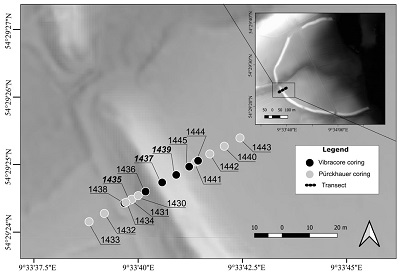 |
| Figure 2. Location of the corings. The zoomed out map represents the digital elevation model of Hedeby and its surroundings with location of the transect. The labels in bold italic font show the main corings of the study. |
3.2. LABORATORY METHODS
In the laboratory, three main Vibracore cores were sampled: one central core at the moat (P. 1435) and two cores through the rampart: P. 1437 at the outer side, P. 1439 at the inner side of the rampart (Figure 2). In addition, several layers/horizons from the Pürckhauer cores were sampled. In total, 139 samples were analysed, and the following parameters were determined: grain size distribution (GSD), content of gravel, charcoal, artefacts, and bones, magnetic susceptibility (MS), loss on ignition (LOI) at 550 °C and 950 °C, pH, and element concentration. The raw data and the description of the methodology can be found in the data article (Vasiullina et al., 2020).
3.3. STATISTICAL METHODS
To understand the complexity of the studied materials and to classify them for further interpretation, multivariate statistical methods were applied. The methodological approach was based on the one described by Khamnueva-Wendt et al. (2020) for the settlement deposits. It was modified for this study owing to the specific properties of the earthwork structure. The statistical analysis was performed in RStudio software.
First, the normality of the data distribution was tested by the Shapiro-Wilk test (p=0.05). A Box Cox transformation was applied to reduce the effect of non-normal distribution. Second, the Spearman’s correlation test with the subsequent Mann Whitney significance test (p=0.05) was performed to assess correlations between variables and to better understand the factors of data variation. Third, the range standardisation method was used to pre-process the data and recalculate the values of different variables into one range from 0 to 1 to minimise the effect of differing scale of the variables. Fourth, the principal component (PC) analysis was applied to the set of values. Despite the simplification of the dataset and possible loss of some information, PC analysis has multiple advantages: it evens up the weight of factors, which was helpful because some of them were described by several parameters; it reduces the “noise” of multiple variables; it decreases the ratio of a number of variables to a number of samples. Only PCs that are described by eigenvalues larger than 1 were used as new input variables for the following analysis. Fifth, the cluster analysis was applied to distribute numerous samples described by the set of chosen PCs into clusters. For distance calculation, the Euclidean method was used, after which the Ward’s minimum hierarchical cluster method was applied. Finally, the resulting clusters were used as a basis for the classification. Thus, the minor manual transformation of clusters into groups was conducted mainly because the morphological properties of material were not represented by variables.
- Results
4.1. TRANSECT DESCRIPTION
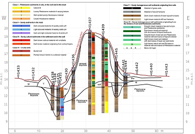
The transect revealed a complex structure of anthropogenic genesis with positive (rampart itself) and negative (moats) relief forms at both sides of the rampart (Figure 3). The main structural units of the transect were (from west to east): the agricultural field outside of the settlement (P. 1432, 1433); the hedgerow between the field and the depression (no corings); the outer filled moat adjoining the rampart (P. 1431, 1434, 1435, 1438); the rampart’s outer slope (P. 1430) with a low plateau (P. 1436); the rampart’s surface (P. 1437, 1439); the rampart’s inner slope (P. 1441, 1444) and the inner filled moat buried under the rampart slope deposits (P. 1445); the field within the settlement (P. 1440, 1442, 1443) (Figure 3). The modern land surface inside the settlement was higher than outside. The inner moat was narrower and shallower than the outer one. An imaginary line that represented the base of the rampart was inclined toward west and had several “steps”, i.e. rather sharp transitions reconstructed based on the stratigraphy of the studied cores, descending to the outer edge of the rampart.
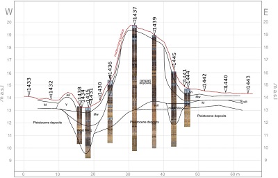 |
| Figure 3. The scheme of the coring transect with the suggested borders of material layers/horizons of different genesis and position of the corings. Used abbreviations: Ah –humus soil horizon, Mw – colluvium originating from the rampart; M – colluvium; Y – hedgerow; Ycult – cultural layer. |
Pleistocene deposits were reached at the base of all cores. They were represented by the following material types: fluvio-glacial sand, glacial till (loamy material; calcareous and non-calcareous), clastic varved deposits, gravel. Pleistocene material varied considerably even within several meters between the neighbouring cores (for detailed description see Vasiullina et al., 2020). In all cores but one Pleistocene deposits were free of soil formation features. At P. 1439 remnants of a buried Cambisol with initial podsolization features were identified at the depth of 524-560 cm below the rampart surface. The cores in the fields on both sides of the rampart (P. 1433 and 1432 in the west and P. 1442, 1440, and 1443 in the east) revealed dark humic colluvium (M), which lied directly on Pleistocene material. Inside the settlement, the finds of artefacts and bone fragments identified cultural layers (Ycult in the core 1443). The deposits of the rampart were observed in the cores 1436, 1437, 1439, and 1445. These materials were characterised by high heterogeneity; the distinguished layers had sharp boundaries and were not concordant throughout neighbouring rampart cores. In contrast, the identified colluvium of the rampart deposits (Mw) in the surrounding fields and in the moats was relatively homogeneous; the transitions between layers were not clear (P. 1430, 1431, 1434, 1435, 1438, 1445). At least two filled moats were identified at the foot of the rampart at its inner and outer sides. Based on the position of the former land surface, which was deduced from the position of the buried soil profile at P. 1439, the outer moat had a maximum depth of around 4 m at P. 1435, while the inner moat discovered at P. 1445 was around 1.9 m deep. The filling of both moats was dominated by sandy material, which was followed by the dark-coloured colluvium Mw in the upper part of the cores. A humic soil horizon Ah was identified in all cores of the transect at the modern land surface. Its thickness varied slightly depending on the micro-topography and the vegetation.
The distinguished layers of the rampart were described as homogenous, when they were morphologically strongly dominated by one type of material, or heterogeneous, when they consisted of several types of material. Heterogeneous layers could be further divided into two groups according to their inner pattern (Figure 4): layering pattern, which was characterised by frequent interchange of sublayers and often by fine layering (individual layers < 1 cm thick); and irregular mixture pattern, which was characterised by different types of material being mixed and with no apparent layering.
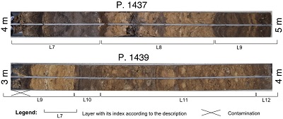 |
| Figure 4. Examples of two types of inner pattern distinguished in heterogeneous layers: layering pattern – layers L7 and L9 in the core 1437; irregular mixture pattern – layers L11 and L12 in the core 1439. |
A selection of properties of three main cores is presented in Figures 5-7. The description of distinguished units is given in Tables 1-3. The base of the moat filling found in the core 1435 was reconstructed according to the first occurrence of inclusions at the depth of 354 cm. The following units were relatively homogeneous with occasional presence of charcoal and anthropogenic inclusions. In combination with organic matter content and MS they allowed distinguishing the layers (Figure 5, Table 1).
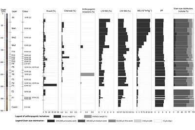 |
| Figure 5. Geo-ecological properties of the sediments of the core 1435. |
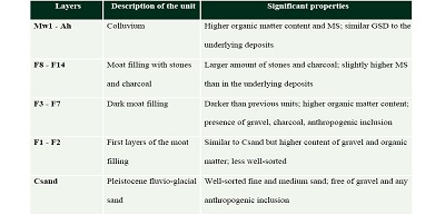
| Table 1. Description of distinguished units of the core 1435. |
 |
The stratigraphic sequence of the core 1437 is extremely heterogeneous (Figure 6, Table 2). The base of the rampart deposits is located at the depth of 665 cm. The underlying Pleistocene material (C1-L0) has a complicated structure as well. The first three layers of the rampart (L1-L3) resemble the buried soil profile, which was observed in the core 1439, and lie stratigraphically parallel to it. However, it cannot be considered an undisturbed soil because of the abrupt border with Pleistocene material situated below, high degree of disturbance, and numerous inclusions of charcoal fragments. The layers distinguished above are mostly highly heterogeneous and every layer consists of several types of material.
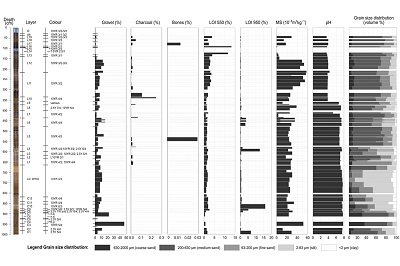 |
| Figure 6. Geo-ecological properties of the sediments of the core 1437. |
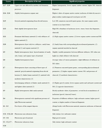
| Table 2. Description of distinguished units of the core 1437. |
 |
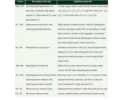
The deposits of the core 1439 are less diverse than in the core 1437 (Figure 7, Table 3). The base of the rampart is located at the depth of 524 cm, which was easily determined by the position of the buried soil (Aeb-Bb). The buried soil is represented by a morphologically undisturbed profile of Cambisol with features of eluviation (Aeb) and weathering (Bb). Layers L19 and L21 consist of two thin sublayers: very dark material with high organic matter content and material with numerous uncoated quartz grains. This sequence reminds of the natural soil profile of Podzols, which consists of organic and eluvial horizons.
| Table 3. Description of distinguished units of the core 1439. |
 |
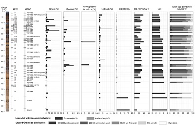 |
| Figure 7. Geo-ecological properties of the sediments of the core 1439. |
4.2. RESULTS OF THE STATISTICAL ANALYSIS
The results of the Shapiro-Wilk test showed the abnormal distribution of all variables, except for fine sand content and Zn content. Thus, the Box-Cox transformation was applied. Correlation matrix presented in Figure 8 illustrates the correlation results. The strongest positive correlation is obtained for clay and silt with associated elements such as elements contained in clay minerals including K, Al, and Rb (fine material indicators), Y and Sr (elements of marine and lacustrine origin), Fe (secondary character of deposition). Silt and clay have a strong correlation with LOI 950 because glacial till sediments have a high carbonate content. pH and Ca concentration show strong positive correlation as pH reaction is alkaline in the presence of CaCO3. All elements mentioned above have a negative correlation with medium sand. On the contrary, P and Si show positive correlation with medium sand and negative with clay, silt, and other elements. P tends to have higher concentration in topsoil horizons that have a sandy texture within the study area as the soils were formed mostly on fluvio-glacial sandy sediments. Si is the main element of the primary mineral contained in sand – quartz. pH is acidic in topsoil horizons; thus, it has a negative correlation with P, Si, medium sand, and LOI 550 but a positive one with the parameters that are positively correlated with clayey and silty materials. P as an indicator of human activities shows a weak positive correlation with artefacts and bones. Parameters of anthropogenic influence do not have a strong correlation between themselves due to the low number of samples with presence of such inclusions. MS has a positive correlation with Fe and Rb due to the nature of magnetic minerals and with P as MS might be considered an indicator of human activity in some cases.
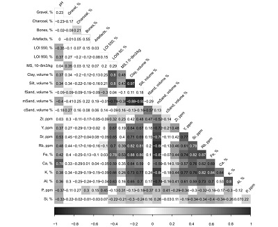 |
| Figure 8. Correlation matrix of 23 variables based on the Spearman’s correlation method. The stronger correlation is presented by the darker colour. Colourless cells are of insignificant correlation (p=0.05). Used abbreviations: fSand – fine sand, mSand – medium sand, cSand – coarse sand. |
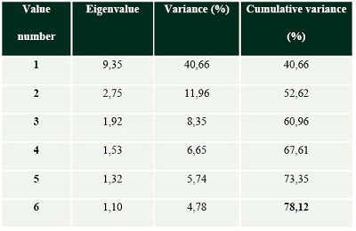
As the result of laboratory analyses a dataset with 139 samples was obtained. Every sample was described by 23 variables with a few missing values because of the insufficient sample amount (Vasiullina et al., 2020). For the following statistical analysis, the values of pH were omitted; thus, only 22 variables were used. Based on the correlation between 22 initial variables, PC analysis calculated new variables that explained the multidimensional space of samples (Table 4). Six PCs were chosen according to their eigenvalues. This set of variables explained 78.12% of data variance.
| Table 4. Eigenvalues and accounted variance of the principal components. |
 |
The projection of variables on the planes of PCs (Figure 9) illustrates the relation between variables and PCs, and thus, the physical sense of PCs. PC 1, which explains 40.7% of variance, divides the samples according to their texture. PC 2 (12.0%) is also related to the texture of material: samples with higher content of coarse sand are characterised by higher gravel content and MS values, while finer material tends to be more organic. PC 3 (8.4%) divides organic-rich from organic-poor loamy material. PC 4 (6.7%) is indicative of cultural material with high content of artefacts and bones. Further, it is more difficult to determine the physical sense of PC 5 and PC 6 but the separation of different types of material can be noted. Thus, PC 5 (5.7%) is sensitive to coarse sandy material, which is more likely characterised by higher MS and LOI 550 values, whereas PC 6 (4.8%) separates the material rich in charcoal.
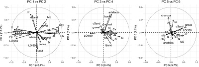 |
| Figure 9. Projection of variables on the planes of PC 1 and PC 2, PC 3 and PC 4, PC 5 and PC 6. The percentages indicate the proportion of the variance explained by the respective PC. The length of a vector correlates to a contribution of a variable. |
Six PCs were used as input variables for the following cluster analysis. 22 clusters were distinguished at height 5.5 (Figure 10). However, these clusters should not be considered as a final classification but as a basis for it (Khamnueva-Wendt et al., 2020); thus, the resulting clusters have to be analysed and transformed if necessary.
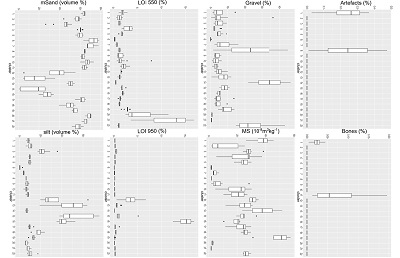 |
| Figure 10. Box and whisker plots of some physicochemical properties for 22 clusters. |
4.2.1. TRANSFORMATION OF THE DISTINGUISHED CLUSTERS
The transformation of clusters was necessary mainly because the morphological parameters were not presented as variables and some of the distinguished clusters did not have any interpretative sense. Nonetheless, the cluster analysis was considered successful for the following types of material: glacial till (cluster 16 distinguished by high LOI 950), loamy Pleistocene material (clusters 12, 13, 15 by GSD parameters), well-sorted sand (cluster 6 by GSD parameters), gravel Pleistocene material (cluster 14 by high gravel content and low values of other variables), cultural material (clusters 1 and 11 by high number of artefacts and bones; and cluster 19 by high MS values). Additionally, some clusters represented similar types of material, which were later attributed to different groups: for example, clusters 3 and 18 – Pleistocene loamy material and mixed layers dominated by Pleistocene material, cluster 4 – topsoil material and material of modern humus horizon formed in colluvium and on top of the rampart, clusters 17 and 18 – mixed layers dominated by topsoil material. After the transformation, the resulted groups represented the material of various genesis (Figure 11).
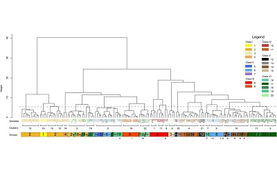 |
| Figure 11. Dendrogram representing the result of cluster analysis and the illustration of the transformation of the clusters. Numbers of clusters are given. Various groups are represented under the dendrogram and are marked by colour and group number. Inclined sections represent secondary groups within clusters. Colourful dots stand for sample outliers. Dashed line drawn at the height 5.5 represents the height of cluster separation. |
Along with morphological properties of material, in some cases the position of layers within the cores became a decisive factor. Thus, the buried soil material, which was located under the rampart deposits at P. 1439 and initially clustered together with other material of soil genesis (cluster 10), was separated into group 10. Similarly, dark material with relatively high content of organic matter (LOI 550), which represented the upper layer at all coring points, was distinguished as group 11.
Clusters 8, 14, and 22 were distinguished according to high gravel content. In the rampart and moat deposits, the presence of stones could be a result of the construction process, and thus, gravel content did not reflect the material origin; at the same time, gravel found in Pleistocene sediments (cluster 14) reflected specific features of the natural origin of material. Therefore, the whole cluster 14 was fully determined as group 4 (gravel Pleistocene material), while the material of clusters 8 and 22 were separated into different groups according to their other properties.
Sediments of such morphologically prominent soil materials as grass sods and material of eluvial horizons were assembled to separate groups. These materials were satisfactory distinguished according to their physicochemical properties to clusters 20 and 21.
As a result of the cluster analysis and cluster transformation, 20 groups of material of various genesis and properties were established (Figure 12). They were assembled to six classes according to the material genesis (Table 5). Despite the necessity of some clusters’ transformation, 68% of samples were initially clustered “correctly” according to the material genesis. A sample was considered to be clustered “correctly” if it represented the most common type of material in a cluster and later constituted the basis for a group of corresponding material genesis.
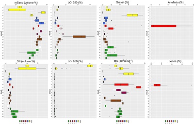 |
| Figure 12. Box and whisker plots of some physicochemical properties for 20 final groups. |
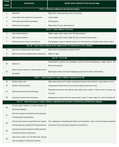
4.3. CLASSIFICATION AND INTERPRETATION OF MATERIAL GENESIS
The groups were distinguished according to the physicochemical and morphological properties of material as described above. The classes reflected the general material genesis. The physicochemical properties, morphological features, and position within cores helped to interpret the genesis of material assigned to a certain group (Table 5). The interpretation should be done with caution because the present features of material are the result of combination of three factors: original properties of the material at the source site, anthropogenic alteration related to the extraction, transportation, and deposition of the material, as well as diagenetic transformation after the rampart construction. Moreover, the interpretation was based only on the analytical deduction because the undisturbed reference materials were mostly absent at the study area and its surroundings. Nonetheless, Pleistocene material and buried soil found within the transect were partly used as a reference.
| Table 5. The classification and genetic interpretation of material. |
 |
In Figure 13 the coring transect with the result of the material classification is shown. The rampart deposits represented a complex inner structure. Pleistocene (yellowish colours), moat (bluish colours) and rampart materials were clearly separated. Two cores through the rampart that were located only 5 m apart were extremely different in the composition. The colluvium and material at the surface of the transect reworked by recent soil formation processes were distinguished by the property of homogeneity, while heterogeneity of the intact rampart deposits was preserved. Layers of gravel and grass sods were distributed without any specific pattern across the rampart deposits.
 |
| Figure 13. Overview of the transect with the representation of material classification. |
In Figure 14 the difference in deposits between two cores through the rampart is clearly seen. In the material of the core 1437 Pleistocene loamy material dominated (33%), whereas cultural material (22%) and mixed layers (30%) had significant shares. A contrasting picture was observed in the core 1439: the heterogeneous layers were predominant (64%) among the rampart deposits and homogeneous layers originating from A soil horizons accounted for 21%. Overall, the core 1437 was estimated to consist of approximately 50% of Pleistocene material and 50% of soil material, while the core 1439 included only 7% of Pleistocene material and 93% of soil material. During this rough estimation the heterogeneous material was attributed to Pleistocene or soil material according to the dominant material in the mixture.
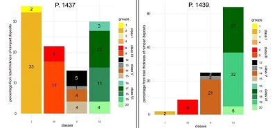 |
| Figure 14. Percentage of the thickness occupied by the groups in relation to the total thickness of rampart deposits for two cores through the rampart. |
- Discussion
5.1. SET OF PARAMETERS AND CLASSIFICATION AS AN APPROACH
The presented method of classification and identification of the earthwork deposits is based on the physicochemical and morphological parameters of materials that constitute the highly heterogeneous earthwork structure, the semi-circular rampart of Hedeby. Initially, a method of material classification was suggested for settlement deposits (Khamnueva-Wendt et al., 2020). However, it demanded adjustments due to specific properties of the earthwork structure such as its complexity and entirely anthropogenic origin. The main adjustments included an increase in the number of parameters (from 6 to 22) and an additional step - a slight manual transformation of the resulting clusters.
During the analysis of the settlement deposits, the original set of parameters (LOI 550, MS, contents of stones, artefacts, bones, and charcoal with wood) was sufficient to separate cultural and natural as well as organic material. Some samples were classified as intermediate material due to the moderate values of parameters. It was also shown that the use of additional parameters (GSD and multi-element concentrations) allowed to identify the origin of material that previously was classified as material with intermediate properties (Khamnueva-Wendt et al., 2020).
To classify the anthropogenically deposited material of the rampart, the additional parameters (LOI 950, GSD, multi-element concentrations) were used for two reasons. First, low content of inclusions in the rampart deposits was not very useful for the separation of cultural material originating from inside the settlement. P content was an important additional indicator of the cultural origin of the material together with MS and content of artefacts and bones. High values of MS corresponded to the burning activity in the anthropogenic context and smithing (Goldberg and Macphail, 2006), and was also helpful in identifying cultural material in the absence of inclusions (group 9). Second, the significant amount of mixed heterogeneous material (30% of the total thickness of rampart deposits in the core 1437 and 64% of the total thickness of rampart deposits in the core 1439) had moderate characteristics of the main parameters. The additional parameters of GSD and multi-element concentrations were valuable for the material separation. GSD parameters were especially sensitive to the presence of Pleistocene material in the mixture as they were also decisive in the separation of different types of Pleistocene material from soils and from each other. It was possible mainly because soils of the study area were developed in fluvio-glacial sands and thus had sandy texture, while most of other Pleistocene material was characterised by finer texture. In addition, content of some elements functioned as GSD, which could be predicted by its positive or negative correlation with various grain size groups.
Diagenetic processes should be considered during the transect analysis. Thus, the material of the core 1435 (moat) starting from the depth 140 cm was characterised by extremely low MS (groups 5 and 7), which is a result of the diagenetic destruction of the magnetic minerals in the reduced conditions of the groundwater presence (Goldberg and Macphail, 2006). Therefore, this parameter cannot be used to identify initial magnetic properties of material as well as some other properties might have been altered. Similarly, the properties of surface layers (group 11) of the transect were not helpful in identifying the material source because they were “overwritten” by modern soil formation process due to the constant input of organic matter and humification as well as the influence of climatic conditions (Ortmann and Kidder, 2013).
Regarding the body of the rampart, the diagenetic processes were expected to be negligible mostly because it did not experience the influence of groundwater and other solutions, surface runoff prevailed over the infiltration. Nonetheless, pH value, which describes the property of a soil solution and tends to be rapidly altered, was omitted from the material statistical analysis without any loss of information.
The clusterization technique increases the objectivity and shortens the time necessary for the analysis of numerous samples. The clusterization results yielded 68% accuracy in the classification of material of the semi-circular rampart as compared to the final grouping that was performed manually. The resulting clusters were taken as a basis for the material classification, and manual adjustments were necessary because the morphological properties were not presented as input variables. The morphological properties were especially important for distinguishing material with very specific properties such as grass sods and eluvial soil horizons, and material mixtures characterised by moderate values. The manual transformation was also necessary in distinguishing the genesis of material with high gravel content. This parameter was helpful in identifying Pleistocene gravel material but gravel and stones found in the rampart deposits could have been anthropogenically added to the layers and thus, it could not be an indicator of the material source.
5.2. TRANSECT INTERPRETATION
For a detailed interpretation of the rampart structure and a reconstruction of its development, multiple transects, in the best case accompanied by excavation trenches, and extensive dating of different stratigraphic units would be necessary. Since such a reconstruction was not a goal of this investigation, only a preliminary interpretation can be proposed based on the results of the described coring transect.
Within the transect, a truncated Cambisol soil profile was observed only under the rampart deposits at P. 1439. Its characteristics corresponded to other buried soil profiles found in Hedeby that were also identified as Cambisol (Khamnueva-Wendt et al., 2020). The initial podzolization feature of the buried soil profile indicated the change of vegetation from woodland to heath as a result of human activity (Behre, 1983). The absence of an Ah horizon and the inclusion of charcoal pieces into the upper part of the preserved horizons imply that the surface was prepared for the fortification construction: existent vegetation was burnt down, and some centimetres of the upper soil horizon were removed together with charred plant material. A similar observation was made during the investigation of another earthwork (Melnikov et al., 2009).
At the field outside the settlement, the soil was completely absent, which could be related either to soil erosion or material extraction for the rampart construction. At P. 1437 the base of the rampart was 60 cm lower than at P. 1439, while at P. 1436 it was even lower than at P. 1437 (Figure 13). Therefore, the area in the direct vicinity of the rampart was modified by humans to a large extent. This speaks for the extraction of soil material and Pleistocene sediments for the rampart construction directly at the area of the fortification structure. The irregular upper border of Pleistocene deposits indicated in Figure 13 suggests that there were likely several phases of rampart construction.
The moat of initial depth of 4 m (P. 1435) was identified at the outer side of the Hedeby’s rampart. A moat adjoining a rampart at its outer side is a common feature of many fortification systems (Jankuhn, 1937; Croix et al., 2019). It is formed as a consequence of the material extraction at the direct vicinity of a rampart, and later it becomes a part of the fortification structure increasing the rampart’s outer effective height (Tvauri, 2012). Far less common is an inner moat that was discovered in the transect. This second moat (P. 1445) is of a significantly smaller volume (initial depth of 1.9 m); it could not have any fortification purpose, but it was probably a “side product” of the material extraction at the direct vicinity. Nonetheless, the phenomenon of additional inner moat is not unique and was also observed in some other fortification systems (Ibsen et al., 2017).
The layers at the bottom of the outer moat (class II, group 7) had the same GSD properties as Pleistocene sand but had inclusions. According to the stratigraphy of Pleistocene material and the outer moat being cut into it, the first filling of the moat represented by well-sorted sand was likely a result of a collapse of Pleistocene material from the slopes of the moat. Other groups of moat filling differed not as drastically from each other as from the lower layers of the moat and represented the colluvium of mainly soil material. Therefore, another common feature of the moat material was its high degree of homogeneity. Consequently, it was difficult to determine the source of material by comparing it to the main types of the rampart deposits.
At the field inside the settlement, two types of colluvial material were found: colluvium originating from the rampart and older colluvium underlying the first one. Developed soil profiles were absent. However, the upper part of the colluvial layer originating from the rampart along the whole transect was transformed by the soil formation process of organic matter humification and was classified accordingly (class IV, group 11, Table 5). At P. 1443 the cultural layer lied between two colluvial layers of different origin; thus, the lower colluvial layer was deposited before the rampart construction, which was consistent with the spatial analysis of the deposits in Hedeby (Wendt et al., 2023) and indicated soil erosion during the early settlement period. The anthropogenic inclusions were found already at a distance of around 15 m east of the inner foot of the rampart.
5.3. SOURCES OF MATERIAL FOR THE RAMPART CONSTRUCTION
The use of material for the earthwork formation depends on its availability in the vicinity of the construction site, tools for its extraction, and functions of the planned object (Tvauri, 2012). The semi-circular rampart protected the emporium of a great economic, political and religious importance being under constant threat in the Viking Age (Dobat, 2008; Hilberg, 2009; Stefánsdóttir and Malück, 2014), thus, it was supposed to be highly stable and durable.
The semi-circular rampart was erected around an already existing settlement most probably in the second half of the 10th century (Jankuhn, 1956; Dobat, 2008; Stefánsdóttir and Malück, 2014). The territory around the settlement was occupied by cemeteries and agricultural fields as the inhabitants of Hedeby consumed products of mostly local production (Behre, 1983; Schietzel, 2014). Thus, the vacant area and sources of available earthen material had to be considered in the planning. Moreover, it was important to decide on the optimal rampart length, size, and configuration as such a massive construction had to fit into the existing proto-urban landscape, fulfil its fortification function, and exploit an adequate amount of resources (both material and labour). The circular and semi-circular fortification ramparts were common in the Viking Age as less material was needed for their construction because of their shape and they were more stable under attack. Some other examples of such constructions are the fortification ramparts in Birka, Ribe, and the Trelleborg fortress (Risberg et al., 2002; Stefánsdóttir and Malück, 2014; Croix et al., 2019).
Generally, it is believed that the volume of the moat should approximately correspond to the volume of the erected earthwork (Tvauri, 2012), which is true for many sections of the Danevirke (Dobat, 2008). The approximate volume of the semi-circular rampart in its present state after the considerable erosion is 100,000 m3 (S. Khamnueva-Wendt, 2023), which dramatically exceeds the volume of two moats that can be roughly deduced from their widths and depths in the investigated transect (Figure 13). Thus, other sources of the material must have been used.
The area for material extractions was limited because the area in the direct vicinity from the rampart carried out important functions for inhabitants of Hedeby: inside the settlement it was occupied by settlement structures and burial sites (Schietzel, 2014), and outside the settlement by agricultural fields (Behre, 1983). Thus, it might have strained builders to excavate relatively deep negative landscape structures with tools such as wooden shovels (Stefánsdóttir and Malück, 2014). Such structures could include the moat at both sides of the rampart, the depression outside the settlement (Werz, 2016; Illers, 2017), the valley-like structure inside the settlement (Khamnueva-Wendt et al., 2023), and the series of ditches that partly repeat the semi-circular form of the rampart at some distance from it (Dobat, 2008; Schietzel, 2014). The smaller moat inside the settlement was discovered only during this investigation: despite its shallow depth (estimated initial depth of 1.9 m compared to initial depth of 4 m of the moat outside the settlement), it could have been sufficient for Pleistocene loam extraction.
The rampart material classification and identification implied that both soil (mostly of sandy texture) and Pleistocene (mostly of loamy texture) materials were collected from the surrounding territory. Loamy Pleistocene material was excavated from the considerable depth as it was discussed above because within the study area it lies under the fluvio-glacial sand. On the other hand, the considerable area in the vicinity of the settlement, which was or could have been used for the agricultural activity, was deprived of its fertility in order to excavate sufficient amount of soil material. However, this could have been a strategic move aimed to establish a wide area without any visual obstacles to be able to detect an approaching enemy from a considerate distance.
Therefore, the material for rampart construction was probably taken from the following main sources: two moats adjoining the rampart; the large depressions in the direct vicinity of the rampart; surface soil horizons; additional (maybe even hidden today) negative structures around the settlement.
5.4. CONSTRUCTION TECHNIQUES
The analysis of the rampart material allowed assuming the use of special construction techniques (use of stones, grass sods, loam material, and deliberate pre-depositional mixing of material), which were mostly applied to increase the structure stability.
The use of stones, tree trunks, and wooden stakes was reported to be used in many contemporary earthworks for construction stabilisation (Jankuhn, 1937; Dobat, 2008; Tvauri, 2012; Bel’skiy, 2019). The steepness of the rampart slopes would suggest the existence of wooden stakes as a slope support measure, as it was previously hypothesised by Jankuhn (1937) as a result of the excavation at the northern and southern sections of the rampart. No tree trunks or wooden stakes were encountered in the investigated cores, which might be related to the limitation of the coring method. However, multiple stones of up to 6 cm in diameter were found in the cores through the rampart, although they were not as large as in other ramparts of the Viking age (Tvauri, 2012; Bel’skiy, 2019) or even other parts of the semi-circular rampart (Jankuhn, 1937). This might have been again partly a result of limitation of the coring method. However, most of the stones in the cores did not show any traces of destruction by coring; also, stones larger than 10 cm in diameter are insurmountable for the used coring method and thus would have blocked the coring, which was not the case in any of the corings. Therefore, we assume that no large stones were present in the analysed rampart deposits. Nonetheless, the chances that the found smaller stones not larger than 6 cm in diameter were transported together with the extracted material are quite low because of the characteristics of undisturbed soil and Pleistocene material within the study area. Thus, these stones might have been intentionally or accidentally added to the material when constructing the rampart.
The use of grass sods was another common technique for the slope stabilisation, usually applied at steep slopes and sometimes at the top of the structure for erosion control (Jankuhn, 1937; Sherwood and Kidder, 2011). This material was easily identifiable in the cores. Nonetheless, they were not found in abundance, partly because it was a limited resource due to its low thickness within the soil profile at the source location and its relatively high “demand” considering the size of the rampart.
Clay material was also often reported to be used for slope stabilisation and erosion control (Jankuhn, 1937; Sherwood and Kidder, 2011; Bel’skiy, 2019). Within the analysed cores no clay deposits or intentional mixing of clay material with another type of sediments were observed, probably because there were no known natural deposits of pure clay material in the surroundings of the settlement. However, loamy Pleistocene and till material, which was accessible even in the direct vicinity of Hedeby, could have been intentionally applied to increase the construction stability. Loamy Pleistocene material was more abundant in the analysed cores than material of glacial till because it was situated above the glacial till according to the stratigraphy of natural deposits, and thus, more easily accessible in the anthropogenically formed negative structures. Also, glacial till deposits are characterised by a very high density and massive structure, which would make their extraction with wooden tools a very difficult task. Moreover, loam could have been used because of the insufficient quantities of soil material. Thus, perhaps it was more reasonable to dig deeper to obtain Pleistocene material of finer texture than to transport the soil material of coarser texture from a significant distance.
There might have been two methods of material deposition: fine interlayering of material during its simultaneous deposition (e.g. L7 and L9 in the core 1437) and intentional material mixing before its deposition (e.g. L11 and L12 in the core 1439) (Figure 4). It was concluded based on the close observation of morphological properties of the layers: the material of simultaneous deposition had horizontal depositional structure, i.e. layering pattern, while in the layers of intentional pre-depositional mixing, the components of different materials were still visible as aggregates and had a random patchy structure, i.e. irregular mixture pattern. Such intentional pre-depositional mixing was also observed in other earthworks (Sherwood and Kidder, 2011): fine material (mostly loamy material) was intentionally added to the main sandier material prior to the deposition for the construction stabilisation.
The careful observation of the cores and the discussion of the used techniques enable us to suggest that during the erection of the semi-circular rampart both methods of earthwork construction were applied (Joyce et al., 2013; Daneels et al., 2018): structured fills by individual loads and backfills with formation of supportive elements, i.e. plausible wooden stakes. The indications of the application of the structured fills by individual loads are the layering pattern, the interchanging deposition of sandy and loamy material, the use of clay material and grass sods for the slope support. In contrast, the use of the method of the backfills with supportive element formation could be expected due to the assumed presence of the supportive wooden stakes and the presence of irregular mixture pattern. The hypothesis on multiple phases of the rampart construction and reinforcement, which was discussed above, advocates for the coexistence of features of two methods of the rampart construction, which might have been applied during different phases.
- Conclusion
The presented approach incorporates the detailed sampling of the core materials, their morphological description, and physicochemical analyses as well as multivariate statistical methods. Such approach aims to increase the objectivity of the classification and interpretation. At the same time, it facilitates the analysis of a large number of samples, and consequently, may increase the degree of detail of the earthwork study.
The set of used parameters exceeds the initially suggested set of six parameters sufficient for the settlement deposits’ classification and interpretation (Khamnueva-Wendt et al., 2020). Additional parameters were applied for two reasons: some of the initial parameters such as content of anthropogenic inclusions were not decisive in case of the earthwork materials; and the earthwork structure consisted of many mixed heterogeneous layers. Therefore, the suggested set of used parameters should be slightly modified in every new case when applying this approach. Thus, the properties of natural materials in the surrounding landscape as well as cultural material should be considered. One parameter tends to be more or less helpful not only in various environmental settings but also in various cultural settings as it was shown in the example of the earthwork and settlement deposits. It can be confirmed that such parameters as content of anthropogenic inclusions, MS, LOI 550, and GSD can be considered obligatory for a geoarchaeological investigation of both settlement deposits and earthwork structures, which lie at the territory with similar landscape characteristics as one presented in this study.
In the case of the highly heterogeneous material, morphological in addition to physicochemical properties were crucial for the material classification and interpretation. Thus, the additional step of manual transformation of clusters was necessary. However, the clusterization results based only on physicochemical parameters showed 68% accuracy.
As a result, 22 variables and 6 PCs were used to classify the material. In the next step, manual transformation of clusters based on the morphological properties of the material yielded 20 groups that were separated into 6 classes according to their genesis. The following classes were determined: Pleistocene material, moat material, cultural material, homogeneous soil material, heterogeneous mixed material, and buried and modern in situ soil horizons. Therefore, the following sources of the material extraction were suggested: moats adjoining the rampart; the large depressions in the vicinity of the rampart located inside and outside the settlement; near-surface materials inside (cultural layers) and outside (natural or partly agriculturally transformed soils) the settlement; additional (maybe even hidden today) negative structures around the settlement. Overall, the rough estimations based on one transect certify that the soil material is predominant in the rampart deposits.
Varying depth of the base of the rampart deposits allowed assuming several stages of the rampart construction. The detailed analysis of the rampart material determined the following techniques used to increase the structure stability: use of grass sods for slope erosion control, depositions of stones, admixture of material of fine texture (loam), intentional pre-depositional mixture of several types of material, wooden stakes as the slope support system. Thus, both structured fills by individual loads and backfills with formation of the supportive elements could have been the methods applied at various phases of the rampart erection and reinforcement.
The presented detailed analysis of one coring transect across such an immense rampart reveals limited but yet important information on the process of the rampart formation. Clearly, it is not sufficient for the reconstruction of the history of the landscape transformation in Hedeby that included the construction of main known anthropogenic structures: the semi-circular rampart, the valley-like depression inside the settlement, and the anthropogenic depression outside the settlement. The next steps would involve the extension of the research to a micro level to reconstruct the history of the rampart formation and post-depositional processes more precisely and a larger level to reconstruct the history of the anthropogenic landscape transformation. The former goal involves the micromorphological analysis of the core material, especially the contact zones, to detect the erosion events, natural periods of soil formation, or cultural stages (Sherwood and Kidder, 2011; Ortmann and Kidder, 2012; Sherwood et al., 2013), which would contribute to the understanding of the history of Hedeby. The accomplishment of the latter goal requires the collection of the statistically more accurate data on the materials used for the semi-circular rampart construction and their proportion by analysing the whole south-western section of the rampart with the use of geoarchaeological and geophysical methods.
Contributions of authors
(1) conceptualization: Khamnueva-Wendt S., Kurgaeva A., Bork H.-R.; (2) analysis or data acquisition: Kurgaeva A., Khamnueva-Wendt S.; (3) methodologic/technical development: Khamnueva-Wendt S., Kurgaeva A.; (4) writing of the original manuscript: Kurgaeva A.; (5) writing of the corrected and edited manuscript: Kurgaeva A., Khamnueva-Wendt S.; (6) graphic design: Kurgaeva A.; (7) fieldwork: Kurgaeva A., Khamnueva-Wendt S.; (8) interpretation: Kurgaeva A., Khamnueva-Wendt S.
Financing
The study was funded by the Institute of Ecosystem Research of Kiel University and the Graduate School “Human Development in Landscapes” of Kiel University.
Acknowledgments
The authors express gratitude to the Archaeological State Office of Schleswig-Holstein and The Viking Museum Hedeby for the permission for the fieldwork. Mathias Bahns, Jann Wendt, Kai Jensen, and Sophia Dazert are thanked for their support during field and laboratory work. The authors also are grateful to Sol Moreno-Roso for the help in translation to Spanish.
Conflict of interest
The authors declare that there is no conflict of interest.
References
Behre, K.E., 1983, Ernährung und Umwelt der wikingerzeitlichen Siedlung Haithabu: die Ergebnisse der Untersuchungen der Pflanzenreste: Neumünster, Germany, Wachholtz, 240p.
Bel’skiy, S. V., 2019, Fortification of Tiuri Linnasaari (Tiverskiy Gorodok) on the Vuoksi river: results and perspectives of current archaeological investigations: Fennoscandia Archaeologica, 36, 156–162.
Bundesanstalt für Geowissenschaften und Rohstoffe, 2016, Bodenatlas Deutschland: Böden in thematischen Karten: Hannover, Germany, 144p.
Croix, S., Gundersen, O.E., Kristiansen, S.M., Olsen, J., Sindbæk, S.M., Søvsø, M., 2019, Dating earthwork fortifications: Integrating five dating methods in Viking-age Ribe, Denmark: Journal of Archaeological Science: Reports, 26, 101906. https://doi.org/10.1016/j.jasrep.2019.101906
Daneels, A., Love, M., Ávalos, E., 2018, Control de presión interna de rellenos en basamentos de la Mesoamérica Prehispánica, in Seminario Internacional de Arquitectura y Construcción con Tierra, 18: La Antigua Guatemala, USAC-CII/PROTERRA, 36-45.
Dobat, A.S., 2008, Danevirke revisited: An Investigation into Military and Socio-political Organisation in South Scandinavia (c AD 700 to 1100): Medieval Archaeology, 52, 27–67. https://doi.org/10.1179/174581708x335431
Fränzle, O., 2004, Reliefentwicklung und Bodenbildung in Schleswig‐ Holstein, in Winkler, G., Dahlke, C., Bork, H.-R., (eds.), EcoSys. Beiträge Zur Ökosystemforschung: Streifzug durch 6000 Jahre Landnutzungs‐ und Landschaftswandel in Schleswig‐Holstein: Ein Exkursionsführer: Kiel, Germany, Vorstand des “Vereins zur Förderung der Ökosysemforschung zu Kiel e.V.” and Direktorium des “Ökologie‐Zentrums der Universität Kiel, 11–35.
Geologischer Dienst Schleswig‐Holstein, 2012, Geologische Übersichtskarte von Schleswig‐Holstein 1:250 000, Flintbek.
Goldberg, P., Macphail, R.I., 2006, Practical and theoretical Geoarchaeology: Oxford, UK, Blackwell Publishing Ltd, 463p. https://doi.org/10.1002/9781118688182
Herrmann, E.W., Monaghan, G.W., Romain, W.F., Schilling, T.M., Burks, J., Leone, K.L., Purtill, M.P., Tonetti, A.C., 2014, A new multistage construction chronology for the Great Serpent Mound, USA: Journal of Archaeological Science, 50, 117–125. https://doi.org/10.1016/j.jas.2014.07.004
Hilberg, V., 2009, Hedeby in Wulfstan’s days : a Danish emporium of the Viking Age between East and West, in Englert, A., Trakadas, A., (eds.), Wulfstan’s Voyage, Te Baltic Sea region in the early Viking Ageas seen from shipboard: Denmark, Viking Ship Museum in Roskilde, 79-102.
Hilberg, V., 2016, Hedeby’s Demise in the Late Viking Age and the Shift to Schleswig, in Holmquist, L., Kalmring, S., Hedenstierna-Jonson, C., (eds.), New Aspects on Viking-Age Urbanism c . AD 750-1100: Sweden, Stockholm University, Archaeological Research Laboratory, 63–80.
Ibsen, T., 2018, Burgwälle als Archive der Sieblungsforschung: ein neuer Ansatz zur Datierung von Burgwällen im Baltikum am Beispiel von Apuolé in Litauen: Archäologisches Korrespondenzblatt, 48 (2), 241-263. https://doi.org/10.11588/ak.2018.2.75185
Ibsen, T., Prassolow, J.A., Eilbracht, H., 2017, Ostpreußen reloaded, in Eriksen, B.V., Abegg-Wigg, A., Bleile, R., Ickerodt, U., (eds.), Interaction without borders: Exemplary archaeological research at the beginning of the 21st century, Vol. 2: Schleswig, Archäologisches Landesmuseum in der Stiftung, 819-831.
Illers, S., 2017, Rekonstruktion der wikingerzeitlichen Geländeoberfläche im Westen von Haithabu: Kiel, Germany, Christian-Albrechts-Universität zu Kiel, Masters thesis.
Jankuhn, H., 1937, Die Wehranlagen der Wikingerzeit zwischen Schlei und Treene: Neumünster, Germany, Wachholtz, 350p.
Jankuhn, H., 1956, Haithabu, ein Handelsplatz der Wikingerzeit: Neumünster, Germany, Wachholtz, 260p.
Jankuhn, H., Schietzel, K., Reichstein, H., 1986, Archäologische und naturwissenschaftliche Untersuchungen an ländlichen und frühstädtischen Siedlungen im deutschen Küstengebiet (Band 2): Deutsche Forschungsgemeinschaft, Weinheim, Germany, Acta Humaniora, 304p.
Joyce, A.A., Levine, M.N., Barber, S., 2013, Place-making and power in the terminal Formative: Excavations on Río Viejo’s Acropolis, in Joyce A. (Ed.), Polity and ecology in formative period coastal Oaxaca: Boulder, the USA, University Press of Colorado, 135-163.
Kalmring, S., 2020, Birka’s Fall and Hedeby’s Transformation: Rewriting the Final Chapters of Viking Town Bibliographies: Journal of Urban Archaeology, 2, 31–50. https://doi.org/10.1484/J.JUA.5.121527
Khamnueva-Wendt, S., Mitusov, A. V., Wendt, J., Bork, H.R., 2020, Classification of buried soils, cultural, and colluvial deposits in the Viking town Hedeby: Geoarchaeology, 35, 313–337. https://doi.org/10.1002/gea.21777
Khamnueva-Wendt, S., Wendt, J., Mitusov, A. V., Kessler, M., Siem, H.-K., von Carnap-Bornheim, C., Bork, H.-R., 2023, Local landscape transformation at the Hedeby-brook valley in the Viking proto-town Hedeby: Electronic Journal, 1-25.
Koster, E.A., 2005, The physical geography of Western Europe: Oxford, UK, Oxford University Press, 472p.
Kottek, M., Grieser, J., Beck, C., Rudolf, B., Rubel, F., 2006, World map of the Köppen‐Geiger climate classification updated: Meteorologische Zeitschrift, 15, 259–263. https://doi.org/10.1127/0941-2948/2006/0130
Laermanns, H., Kirkitadze, G., May, S.M., Kelterbaum, D., Opitz, S., Heisterkamp, A., Basilaia, G., Elashvili, M., Brückner, H., 2018, Bronze Age settlement mounds on the Colchian plain at the Black Sea coast of Georgia: A geoarchaeological perspective: Geoarchaeology, 33, 453–469. https://doi.org/10.1002/gea.21670
Lang, V., 2012, Building remains at the hill fort of Keava: Estonian Journal of Archaeology, 1, 11–35. https://doi.org/10.3176/arch.2012.supv1.02
Melnikov, L.V., Bugrov, D.G., Nurislamov, R.K., Mironov, I.N., 2009, The characteristics of postperogenic derivates of soil horizons and stratigraphic features of fortification bank of Early Iron Age: Middle Volga and Southern Ural: Man and Nature in Ancient Times (Collection of Scientific Articles in Memory of Kazakov E.P.), Kazan, Russia, “Fen” AN RT, 149–164.
Nadel, D., Bar-Oz, G., Avner, U., Malkinson, D., Boaretto, E., 2013, Ramparts and walls: Building techniques of kites in the Negev Highland: Quaternary International, 297, 147–154. https://doi.org/10.1016/j.quaint.2012.11.037
Ortmann, A.L., Kidder, T.R., 2013, Building Mound A at Poverty Point, Louisiana: monumental public architecture, ritual practice, and implications for hunter-gatherer complexity: Geoarchaeology: An International Journal, 28(1), 66-86. https://doi.org/10.1002/gea.21430
Risberg, J., Karlsson, S., Hansson, A., Heimdahl, J., Miller, U., Tingvall, C., 2002, Environmental changes and human impact as recorded in a sediment sequence offshore from a Viking Age town, Birka, southwestern Sweden: The Holocene, 12, 4, 445–458. https://doi.org/10.1191/0959683602hl558rp
Schietzel, K., 2014, Spurensuche Haithabu: Archäologische Spurensuche in der frühmittelalterlichen Ansiedlung Haithabu; Dokumentation und Chronik 1963‐2013: Neumünster, Germany, Wachholtz, 647p.
Sherwood, S.C., Kidder, T.R., 2011, The DaVincis of dirt : Geoarchaeological perspectives on Native American mound building in the Mississippi River basin: Journal of Anthropological Archaeology, 30, 69–87. https://doi.org/10.1016/j.jaa.2010.11.001
Sherwood, S., Blitz, J., Downs, L., 2013, An Integrated Geoarchaeology of a Late Woodland Sand Mound: American Antiquity, 78(2), 344-358. https://doi.org/10.7183/0002-7316.78.2.344
Stefánsdóttir, A., Malück, M., 2014, Viking age sites in Northern Europe. A transnational serial nomination to UNESCO´s world heritage list: Archaeologisches Landesamt Schleswig-Holstein, Prentmet, 441 p.
Stephan, H.J., 2014, Climato-stratigraphic subdivision of the Pleistocene in Schleswig-Holstein, Germany and adjoining areas: Quaternary Research, 63, 3–18. https://doi.org/10.3285/eg.63.1.01
Tummuscheit, A., Witte., F., 2019, The Danevirke: Preliminary results of new excavations (2010-2014) at the defensive system in the German-Danish borderland: Offa’s Dyke Journal, 1, 114-136. http://dx.doi.org/10.23914/odj.v1i0.253
Tvauri, A., 2012, The Migration Period, Pre-Viking Age, and Viking Age in Estonia: Tartu, Estonia, Tartu University Press, 384 p.
Vasiullina, A., Khamnueva-Wendt, S., Wendt, J., Bork, H.R., 2020, Dataset on the deposits of the semi-circular rampart around the former Viking settlement Hedeby and its vicinity: Data in Brief, 33, 106493. https://doi.org/10.1016/j.dib.2020.106493
Wendt, J., Mitusov, A., Khamnueva-Wendt, S., Khrisanov, V., Emadodin, I., Kurgaeva, A., Bork, H.-R., 2023, Spatial variability of soil remnants, cultural and colluvial deposits in a small dry valley in the Viking settlement Hedeby, Northern Germany: Journal, 1-26.
Werz, S., 2016, Geoarchäologische Untersuchungen zu Ausmaß und Nutzung: Kiel, Germany, Christian-Albrechts-Universität zu Kiel, Masters thesis.
Peer Reviewing under the responsibility of Universidad Nacional Autónoma de México.
This is an open access article under the CC BY-NC-SA license(https://creativecommons.org/licenses/by-nc-sa/4.0/)