
|
Boletín de la Sociedad Geológica Mexicana Volumen 76, núm. 2, A250224, 2024 http://dx.doi.org/10.18268/BSGM2024v76n2a250224
|
 |
Burning effects on the soils of the Mexican Maya Lowlands: Current evidence for understanding past events
Efectos de quemas en los suelos de las Tierras Bajas Mayas en México: Evidencias actuales para entender eventos del pasado
Sol Moreno-Roso1,2,*, Elizabeth Solleiro-Rebolledo2, Sergey Sedov2, Bruno Chávez-Vergara2,3,
Agustín Merino4
1 Posgrado en Ciencias de la Tierra, Universidad Nacional Autónoma de México, Ciudad Universitaria, Coyoacán 04510, CDMX, México.
2 Instituto de Geología, Departamento de Ciencias Ambientales y del Suelo, Universidad Nacional Autónoma de México, Ciudad Universitaria, Coyoacán 04510, CDMX, México.
3 Laboratorio Nacional de Geoquímica y Mineralogía, Ciudad Universitaria, Coyoacán 04510, CDMX, México.
4 Departamento de Edafología y Química Agrícola, Escuela Politécnica Superior de Ingeniería, Universidad de Santiago de Compostela, 27002, Lugo, Spain.
* Corresponding author: (S. Moreno-Roso) This email address is being protected from spambots. You need JavaScript enabled to view it.
How to cite this article:
Moreno-Roso, S., Solleiro-Rebolledo, E, Sedov, S. Chávez-Vergara, B., Merino, A., 2024, Burning effects on the soils of the Mexican Maya Lowlands: Current evidence for understanding past events: Boletín de la Sociedad Geológica Mexicana, 76 (2), A250224. http://dx.doi.org/10.18268/BSGM2024v76n2a250224
Manuscript received: November 8, 2023; corrected manuscript received: February 12, 2024; manuscript accepted: February 26, 2024.
ABSTRACT
The slash-and-burn cultivation system is a millenarian practice still used in many countries today, with significant environmental impacts. However, identifying evidence of this agricultural method in soil records is challenging due to natural and human factors that can obscure or alter fire signals. This challenge is particularly evident in the Yucatán Peninsula, where the ancient Maya practiced slash-and-burn agriculture in a dynamic tropical karst environment, making it difficult to pinpoint the origins and consequences of this practice. In this study, we use a recent agricultural burning in a karstic landscape in Chiapas as a model to understand alterations in soil properties. We then apply these insights to identify similar features at a Maya site on the Yucatán Peninsula, specifically at Coyote Quarry. For both cases, we conducted micromorphological analysis, soil physical-chemical characterization, thermogravimetry and differential scanning calorimetry analysis, and radiocarbon dating of mollusk shells, soil organic carbon, and charcoal fragments (the latter exclusively at Coyote Quarry). Our findings reveal significant effects on the soils from the Chiapas site post-burning, including changes in grain size distribution, pH, and total organic and inorganic carbon. These results were compared to those obtained from the Coyote Quarry soils and pedosediments. Key findings include micromorphological features, the presence of charcoal and other burned materials, and pyrogenic carbon identified through thermal analyses. The preservation of these burned features was facilitated by the typical karstic vertical soil erosion and redeposition as pedosediments in karstic depressions. The intrinsic association of the fire signals found in these karstic sinkholes and their radiocarbon dates enables us to link this evidence to the initiation of slash-and-burn agriculture by the Maya in the Yucatán Peninsula during the transition between the Archaic and Early Pre-Classic periods.
Keywords: Maya, slash-and-burn agriculture, pyrogenic carbon, soil erosion, pedosediments, karstic pockets.
RESUMEN
La roza-tumba y quema es una práctica agrícola milenaria que tiene un fuerte efecto sobre el medio ambiente. Sin embargo, no es fácil identificar las señales de esta práctica en los registros edáficos debido a factores naturales y antrópicos. Particularmente en la Península de Yucatán, los antiguos mayas utilizaron la roza-tumba y quema en un ambiente kárstico tropical muy dinámico, en donde, reconocer el inicio y las consecuencias de esta práctica, es aún controversial. En esta investigación, utilizamos una quema agrícola reciente en el paisaje kárstico de Chiapas, como modelo para entender las alteraciones de las propiedades del suelo e identificar qué rasgos permanecen en un sitio Maya antiguo de la Península de Yucatán. Para ambos casos, realizamos análisis micromorfológicos, caracterización fisicoquímica de los suelos y pedosedimentos, análisis térmicos de la materia orgánica y dataciones de radiocarbono (exclusivamente en Yucatán). Encontramos efectos intensos en los suelos del sitio de Chiapas después de la quema, con cambios en la distribución granulométrica, en el pH y en el carbono orgánico e inorgánico. Estos resultados se compararon con los obtenidos en los suelos y pedosedimentos de la Cantera Coyote. Los principales hallazgos están relacionados con las características micromorfológicas: presencia de carbón vegetal y otros materiales quemados, así como la identificación de carbono pirogénico en los análisis térmicos. La preservación de estos rasgos de quema se ve favorecida por la erosión vertical del suelo en el karst y la redeposición de estos pedosedimentos en depresiones kársticas. La asociación intrínseca de la señal del uso del fuego encontrada en estas depresiones y sus dataciones nos permiten relacionar esta evidencia con el inicio de la práctica de la roza-tumba y quema por los Mayas en la Península de Yucatán en la transición entre el Arcaico y el Preclásico Temprano.
Palabras clave: Maya, agricultura de roza-tumba y quema, carbono pirogénico, erosión de suelos, pedosedimentos, bolsas kársticas.
- Introduction
The use of fire by humans began ∼1.6 million years ago by early hominins in Africa (James, 1989), although this date is still controversial (Gowlett et al., 1981; Clark and Harris, 1985). However, there is no doubt that fire has constituted a crucial tool in humanity’s development (Bowman et al., 2013; Gowlett, 2016) and its use can be considered as a tracker of anthropic environmental impacts (Pyne, 2020). The fire impact on the environment is found in the sedimentary record with charcoals and burned rocks, which in consequence, have been used as a signal of human presence and different fire utilities in archaeological contexts such as heating, illumination, cooking, ceremonies, landscape clearance for agriculture or hunting, among others (Alperson‐Afil, 2012, Santín and Doerr, 2016; López-Martínez et al., 2020).
Ancient use of fire could be subdivided according to its spatial dimensions into local, i.e., restricted to settlements, or regional. Local burning for domestic needs was strictly controlled; it usually took place in special constructions or marked and arranged places (ovens, hearths, etc.) and presented small-scale but frequently repeated action. Usually, it is easy to identify fireplaces in archaeological contexts with the help of geoarchaeological tools. Regional burning is aimed at landscape and ecosystem change for certain economic activities. Already hunter-gatherer Palaeolithic societies of the Old World used fire throughout the Late Pleistocene to open the landscape for grass vegetation, which was attractive for large herbivores – the main hunting object (Roebroeks et al., 2021; Thompson et al., 2021). Much more extensive and frequent vegetation burning started with the onset of agricultural economy. Fire is an essential factor in the origin of agriculture and is still present in the millenarian “slash-and-burn” or “shifting cultivation” system around the world (Palm et al., 2005). However, identifying the slash-and-burn impact in the paleoenvironmental and archaeological records is not easy due to the existence of diverse agricultural practices and the scarce empirical information on how farming burning is recorded in soils (Eckmeier, 2007a; Arroyo-Kalin, 2012; Dussol et al., 2021). Micro-charcoals (<1 mm) in lacustrine sedimentary records have been used to infer slash-and-burn practices on the regional scale (e.g., McMichael et al., 2012; Dietze et al., 2018). In soils that could provide indicators of local burning, this method is known as “pedoanthracology” (or the study of charcoals in soils) which in combination with other paleoenvironmental and archaeological tools has helped to identify this agricultural practice (Carcaillet, 1998; Morin-Rivat et al., 2016; Ponomarenko et al., 2019). Eckmeier et al. (2007a, 2007b) performed an experimental burning of a temperate deciduous forest in Germany to mimic Neolithic agricultural slash-and-burn, finding a heterogenous charcoals spatial distribution with a domain of macro-charcoals (>1 mm), immediately after burning. After one year, a few charcoals were incorporated into the soil by bioturbation. A similar study (Dussol et al., 2021) was done in an agrarian area within a tropical forest in the north of Guatemala, where ancient Mayans used slash-and-burn agriculture, and the signature of this practice was identified by combining pedoanthracology and the analysis of infra-millimetric soil charcoals (100–400 μm).
Although slash-and-burn practices have important impacts on soil properties (Ketterings et al., 2000; Ketterings and Bigham, 2000; Santín and Doerr, 2016), the majority of the studies use only charcoals as the main proxy of fire evidence, due to: 1) pedoturbation processes that can erase or overlap the signals (DeBano et al., 1998; Dussol et al., 2021); and 2) the resistance of pyrogenic carbon whose biochemical stability depends on its formation temperature, aromaticity, and degradation environmental settings (Knicker, 2023). Even more, its translocation or burial after erosion/deposition processes deeper into the soil can help its preservation for thousands of years due to the oxygen decline that can decrease the biodegradability rate of this material (Hobley et al., 2017; Abney and Berhe, 2018; Knicker, 2023).
The Yucatán Peninsula, located in SE Mexico, represents an area of long-term human development since the Pleistocene–Holocene transition (González et al., 2008). The oldest charcoal concentrations associated with anthropic combustion structures are dated between 10740 and 7951 cal BP. They were found in different submerged caves in Quintana Roo, suggesting that they corresponded to hearths used for illumination or heating when the caves were dry even before the development of agriculture in the region (González et al., 2008; Hering et al., 2018; López-Martínez et al., 2020).
In the Maya Lowlands, the early agriculture evidence was determined by the finding of Zea mays pollen around 7000 years BP ago (Pohl et al., 2007). However, the intensification of deforestation started 5000–4000 years BP (Jones, 1994; Pohl et al., 1996; Pope et al., 2001; Wahl et al., 2006). Deforestation together with the slash-and-burning agriculture in the Maya territory could produce changes in climate, vegetation, and soil erosion rate (Beach et al., 2015; Schüpbach et al., 2015; Dunning et al., 2023) although this anthropogenic environmental impact is still a topic of discussion; however, some researchers consider that these changes could result from the interaction of both factors (Schüpbach et al., 2015). One of the difficulties to understand such changes in the karstic landscapes of the Maya lowlands is the preservation of ancient burnings signals into the soil due to a reduction of the soil memory because of the active surface erosion as well as by the warm and humid conditions that increase the microbial degradation of pyrogenic carbon (Knicker, 2023; Sedov et al., 2023). Nevertheless, the preservation of charcoal in different karstic landscapes from Mexico and Russia has been already documented (Cabadas-Báez et al., 2010; Mergelov et al., 2020; Sedov et al., 2023). The conservation of burned features (charcoals, burned shells, charred rocks) can be favored by the vertical soil erosion or “soil piping” process, which transports surficial particles to the karstic depressions (White and Culver, 2012; Sedov et al., 2023).
Although there are several studies on the effects of local burning on soils in geoarchaeological contexts, research on the effects of ancient burnings on soils at the landscape level is scarce. In this work, we study two sites in the karstic landscapes of the Maya lowlands, related to a recent burning induced by humans to prepare the land for cultivation in the state of Chiapas; and soils and pedosediments (redeposited soils) located inside a quarry in the Yucatán Peninsula, an area deeply impacted by slash-and-burn agriculture during the ancient Maya occupation. We consider the effects of the recent burning on soils in the Chiapas area as a model to understand the transformations in soil properties that remain stable in time. We hypothesize that these alterations can be extrapolated to other karstic landscapes, such as the Yucatán Peninsula, where similar soils and ecosystems are found. Thus, this work aims to establish the burning indicators after an intentional burning in an agriculture field in Chiapas and compare them with ancient soils and pedosediments properties at the karst system at Yucatán. With this information, reconstruct the effect of ancient agriculture on the soils impacted by the ancient Maya societies.
- Materials and methods
2.1. Geological and environmental characteristics of the studied sites
Chiapas (CHI): The recent burning site is found at Sierra de Chiapas (Figure 1), near the Mexico-Guatemala border, in a farm field (17°3’48.06” N; 91°16’3.90” W) recently burned for agriculture purposes. Sierra de Chiapas belongs to the southern area of the Maya block, a tectonostratigraphic terrain with Permian–Triassic igneous and metamorphic rocks in its basement, overlain by continental volcanic and sedimentary deposits from the Lower Jurassic to Cenozoic (Garduño-Monroy et al. 2015). The Sierra is folded with anticline and syncline structures, oriented E-W to NW-SE. The Sierra is constituted by limestones and sandstones to claystones, which is affected by neotectonics (García-Molina, 1994; Meneses-Rocha, 2001). It represents the biggest mountainous tropical karst in Mexico (Espinasa-Pereña, 2007: Andreani and Gloaguen, 2016). The region has a humid tropical climate with strong wet and dry seasons, where the mean annual precipitation recorded in the area was 2000–2800 mm between 1960 and 2016, with 24°C for the mean annual temperature (Johnson et al., 2007; Andrade-Velázquez and Medrano-Pérez, 2020). These climatic conditions allow the development of a tropical humid forest (INEGI, 2019a).
Coyote Quarry (CQ): The Pre-Hispanic burning site is found in the coastal plain of Quintana Roo, NE Yucatán Peninsula (Figure 1), at the Coyote Quarry (20°31’52.30”N, 87°12’34.92”). The Yucatán Peninsula comprises a thick marine sedimentary sequence of limestones, dolomites, and evaporites from Cretaceous to Quaternary over a Paleozoic basement that conforms an uplifted carbonate karstic platform of a low geomorphic relief (Lopez-Ramos, 1975; Weidie, 1985; Ward, 1985). According to Fragoso-Servón et al. (2019), this area corresponds to an erosive-accumulative littoral geomorphic environment at the transition between the undulated plains tecto-karst and the sea. The climate in this zone is hot and sub-humid, with a mean annual temperature of 26 ºC and 1234 mm of annual precipitation (García, 2004) with a tropical sub-humid forest (INEGI, 2019b).
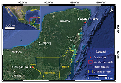 |
| Figure 1. Studied area’s location in the Maya Lowlands in southeastern Mexico. The recent burning site near to Chiapas and Guatemala border and the Pre-Hispanic Maya site in the Yucatán Peninsula at Quintana Roo northern coast. |
According to Sedov et al. (2023), who studied soil toposequences in tropical karstic landscapes of southern Mexico, there are two main soil types in both the Yucatán Peninsula and Chiapas areas: shallow Rendzinas (Rendzic Leptosols (Humic)) and deep Terra Rossas (Chromic Luvisols (Humic); soil classification according to INEGI, (2007a, 2007b). The karstic agricultural landscape in the Maya Lowlands has been characterized by the transformation of areas covered with natural vegetation to cultivation land and, more specifically, to the slash-and-burn agriculture where the forest is cleared and converted into a farmland. This clearance is accompanied by burnings, producing ashes that represent a source of some nutrients (Wilhelmy, 1989; Faust, 2001).
The Quintana Roo area has abundant archaeological evidence of Maya settlers, with important Classic (AD 250–950) and Post-Classic (AD 950–1539) cities such as Coba and Tulum, respectively. However, sedentary human occupation started during the Middle Pre-Classic (1000–350 BC), which represents a long period (more than 3000 years) of continuous Maya settlements. During the 3000 year-period, the enormous transformation of the tropical ecosystem caused by ancient Mayans has been registered in several places. Particularly, Beach et al. (2015) recognized large environmental changes due to the impact of Maya Civilization (from 3000 to 1000 BP), that even name such periods as Mayacene or Maya Early Anthropocene. Evidence of the impact has been also connected to accelerated fires (Beach et al., 2015).
2.2. Field work
We collected samples from the two sites in 2019 following the same procedures: around 1 kg of bulk samples for laboratory analyses and unaltered soil blocks for micromorphological observations. However, according to the characteristics of each site, the morphological descriptions were not done homogeneously. In Chiapas, a portion of an open agricultural area had recently burned for cultivation purposes, and this slash-and-burn shifting has been a recurrent practice; here, four soils were sampled the same day that the burn occurred: i) unburned black soil (CH03), ii) unburned red soil (CH01), iii) burned black soil (CH02), and iv) burned red soil (CH04). The sampling and descriptions were limited to the top layer (6 cm) of soil as this is the part most affected by slash-and-burn agricultural practices (Ketterings and Bingham, 2000; Thomaz et al., 2014). The black soils correspond to Rendzic Leptosols (Humic), and the red ones belong to Chromic Luvisols (Humic) (INEGI, 2007a, 2007b); however, as we did not pay attention to the taxonomy of the soils, we further refer to black and red soils.
Three different materials were studied at the Coyote Quarry in Quintana Roo: The first one, in a soil profile excavated on top of the quarry where the vegetation was still preserved; and the other two on the quarry walls: i) a modern Rendzina type soil (Selva-depresión profile; Rendzic Leptosols (Humic) (INEGI, 2007b)), ii) a modern soil in a karstic pocket (Negra Gorda profile; Rendzic Leptic Phaeozem (Humic) INEGI, 2007b)), and iii) pedosediments located at the floor level of a collapsed cave (PSPO1 and PSPO2, Figure 2).
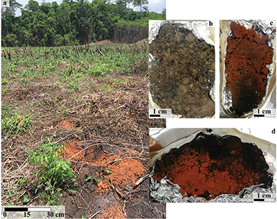 |
| Figure 2. a) Slash-and-burn agriculture in Chiapas tropical forest. b) Unburned black soil sample (CH03, Leptosol), c) burned black soil (CH02, Leptosol), and d) burned red soil (CH04, Luvisol) from the site mentioned in a). Landscape photo by Sergey Sedov. |
2.3. Laboratory analysis
In this study, micromorphology was used as the primary method for the determination of the burning evidence. In the soil thin sections, ash, charcoal, burned and reddened aggregates, charred rocks, burned bones, and charred shells were identified according to Nicosia and Stoops (2017), Stoops et al. (2018) and Moreno-Roso et al. (2023). However, micromorphology has some limitations for the discrimination of pyrogenic evidence from similar features of pedogenic processes, such as pigmentation of the soil groundmass with dark humus or reddish aggregates product of advanced pedogenesis. For this reason, micromorphology is accompanied by specific methods to differentiate pyrogenic and pedogenic features, such as the evaluation of selected physical and chemical properties and thermogravimetry.
2.3.1. Micromorphological analysis
The unaltered soil blocks collected in the field were used to prepare thin sections (30 μm-thick). The samples were dried and impregnated at the laboratory with polyester resin (Figure 3b). The micromorphological analysis was performed with a petrographic microscope (OLYMPUS). A digital camera connected to the microscope and a computer with the Image-Pro Plus 7.0 software was used to capture the fire evidence images in soil-thin sections.
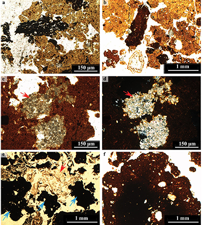 |
| Figure 3. Micromorphology of soils from Chiapas site. a) Charcoals fragments and b) charred dark reddish pedosediments included in a clayey groundmass of the unburned black soil (CH03, Leptosol), with parallel polarized light (PPL). c) Pyrogenic calcite crystals (red arrow) with individual rhomboidal shape result of ashes filling pores in a reddish clay matrix of the burned black soil (CH02, Leptosol; PPL). d) Same pyrogenic calcite crystals (red arrow) as c), but with cross polarized light (XPL). e) Amorphous char (blue arrows) and ashes (red arrow) in the burned red soil (CH04, Luvisol; PPL). f) Burned reddish-clay aggregate with a dark nucleus in the burned red soil (CH04, Luvisol; PPL). |
2.3.2. Physical analysis
Changes in soil color after burning have been reported in several studies (e.g. Ulery and Graham, 1993; Terefe et al., 2005; Ketterings and Bigham, 2000; Badía and Martí 2003; Cancelo-González et al., 2014). Therefore, we evaluated the changes in the color of the studied samples to, at first glance, determine if the soil was or was not affected by fire. For color measurements, we used a portable spectrophotometer (ColorLite Sph 870). This colorimeter follows the CIELAB color system (CIE, 1986), which characterizes the color by three parameters: L* (luminosity), from 0 (black) to 100 (white); a* > 0 (redness) and a* < 0 (greenness); and b* > 0 (yellowness) and b* < 0 (blueness) (Cancelo-González et al., 2014). Colors were measured in triplicated on sieved (2 mm) and homogenized samples.
Some studies have reported changes in soil texture in burned soils (Ulery and Graham, 1993; Ketterings et al., 2000). Thus, the soil texture was determined following Flores-Delgadillo and Alcalá-Martínez (2010). First, to eliminate carbonates, samples were treated with sodium acetate (C2H3NaO2 1 M pH 5, 1:10, 10 ml mixed with 100 ml of distilled water, discarding the supernatant after centrifugation and repeating three times the procedure); to remove the organic matter, 5ml of 10 % H2O2 was added and the mixture heated at 60 ºC and until the reaction ended; to eliminate free iron oxides a dithionite-citrate-bicarbonate solution was added (for details see Flores-Delgadillo and Alcalá-Martínez, 2010). The particle size distribution was quantified, separating sand (2–0.05 mm) by sieving (53 μm mesh) and silt (0.05–0.002 mm) and clay (>0.002 mm) by gravity sedimentation (pipette method).
2.3.3. Chemical analysis
We determined soil pH in distilled water (1:2.5 W:V ratio) by a portable pH meter (Thermo) on previously dried samples. This property usually increases after fires (Alcañiz et al., 2018; Agbeshie et al., 2022).
Changes in soil carbon after fires have been extensively studied (Alcañiz et al., 2018; Agbeshie et al., 2022). The quantification of the total carbon (TC) and the inorganic carbon (IC) was made by the coulometric method (Huffman, 1977) with a total carbon analyzer (UIC model CM5012, Chicago, USA) on previously dried soil samples at 105 ºC until constant weight. At the same time, the total organic carbon (TOC) concentration was obtained by the difference between TC and IC.
2.3.4. Thermal analysis
Soil organic matter is modified during fire events, losing the most thermolabile (microbial functional groups and carbohydrates) and alkyl compounds together with an increase of aromatic compounds, such as pyrogenic carbon (Knicker et al., 2008). Pyrogenic carbon is a recalcitrant product, more resistant to microbial attack and thermal oxidation, than fresh vegetal remains or labile organic matter (Singh et al., 2014; Dell’ Abate et al., 2002). Therefore, to discriminate the soil organic matter (SOM) of pyrogenic origin from that formed by pedogenic processes, some samples were selected to characterize their organic matter thermo-quality (Barros et al., 2010). Five samples (unburned and burned red soils (CH01 and CH04) from Chiapas; A horizons from Selva-depresión and Negra Gorda profiles, and the PSPO1 pedosediments from the collapsed cave were analyzed by Differential Scanning Calorimetry (DSC) and Thermogravimetry Analysis (TGA) with a TGA/ DSC1 thermogravimetric analyzer, Mettler Toledo, following the method described in Merino et al. (2015). The samples (4 mg) were placed in open aluminum containers with dry air (under O2 flux; flow rate, 50 mL-1) and scanned at a rate of 10 ºC-1 in a temperature between 50 and 600 ºC. With the temperature increase, the loss of matter (TGA) and the heat or energy release (DSC) were measured (Merino et al., 2015). The obtained data were processed using STARe Mettler Toledo software to generate the DSC and TGA curves and other thermal parameters described in Merino et al. (2015). According to Dell’ Abate et al. (2002) and Fernández et al. (2011), the obtained thermogram curves can be divided into three regions that represent the resistance to thermal oxidation: labile organic matter (200–375 °C, carbohydrates, and aliphatic compounds); recalcitrant organic matter (375–475 °C, lignin and polyphenols); and highly recalcitrant organic matter (475–550 °C, polycondensed aromatic compounds). We also obtained the parameter T50q to indicate the temperature at which 50% of the energy is released.
2.3.5. Radiocarbon dates
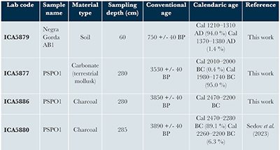
The age of the materials inside the karstic depressions was established by radiocarbon dating analysis done by the International Chemical Analysis Inc. (ICA; Table 1). The selected samples were: 1) soil organic matter of the AB1 horizon from the Negra Gorda profile; 2) charcoals and a terrestrial mollusk from the cave pedosediments (PSPO1); 3) a charcoal fragment from the same cave pedosediments PSPO1, previously published in Sedov et al. (2023). The sampling depth of each material is presented in Table 1.
| Table 1. Radiocarbon dates (14C) of the charcoals and mollusks of the selected soils and pedosediments from the Coyote Quarry. |
 |
- Results
3.1. Soil characteristics as a consequence of the burning in Chiapas
3.1.1. Macromorphological characteristics
The topsoil of the materials not affected by burning preserved the natural colors (Figure 2a). Organic materials on the A horizons were detectable in different stages of decomposition. The unburned black soil (CH03) showed a dark brown color, with a primary subangular blocky structure (dominant aggregate size is 3–5 cm diameter) and scarce minor granular aggregates; few thin roots and degraded vegetal remains were present. The unburned red soil (CH01) showed a dark reddish color, a clayey texture, and a subangular blocky structure. The aggregate size varied between 3 and 0.5 cm. There were no roots or vegetal remains.
In the case of the soil affected by burning (Figure 2b), we observed changes in color, structure, and in the organic materials. The burned black soil (CH02) presented a dark black Ah horizon with a subangular blocky structure. However, it showed aggregates of smaller size (2–0.5 cm in diameter) with respect to the unburned soil. Most of the aggregates were charred, but few aggregates exhibited a reddish color. The surface of this burned horizon showed completely and partially charred vegetal remains. The burned red soil (CH04) was reddish, showing a subangular blocky structure. The aggregate size was comparable to the unburned red soil, with a few black-colored aggregates. It was highly clayey, with burned and unburned vegetal remains on the topsoil.
3.1.2. Micromorphological features
The unburned black soil (CH03) showed a brown clayey groundmass with a subangular blocky structure (Figures 2, 3a, 3b). Silt and sand-size quartz grains and few coprolites were common. Although this soil was considered unburned, fragments of charcoal and rounded reddish and charred dark reddish pedosediments were frequently included in the groundmass. These were evidence of previous burnings. In contrast, the burned black soil (CH02) exhibited a reddish color on the first 4 cm and a dark reddish color below (Figure 2). Ashes were common and showed the characteristic individual rhomboidal shapes of calcite crystals forming clusters filling pores (Figures 3c, 3d). Very few charcoal fragments were present. In the first centimeter of the burned red soil (CH04), a dark black color constituted by charred aggregates forming a loose and sub-rounded blocky structure was observed (Figure 3e, 3f). Then, in the next centimeters, a clayey and rubified soil groundmass appeared, showing a subangular blocky structure. Some aggregates presented a dark center with a reddish border. There were ashes associated with a few small charcoals. Other charcoals were included in the groundmass, possibly from previous burned events. Besides, some reddish and dark brown rounded pedosediments were present.
3.1.3. Physical and chemical characteristics
The particle size distribution of the Chiapas unburned soils indicated a clear difference in the clay and sand contents concerning their respective burned samples (Figure 4). The unburned black soil was dominated by 94.4% of clay, while the burned black soil just exhibited 46.0%, reaching up to 42.4% of sand-size particles. The unburned red soil showed 88.0% of clay and only 3.6 % of sand, while the burned one presented 20.4% of clay and 73.9% of sand-size particles.
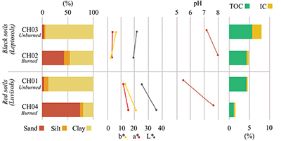 |
| Figure 4. Physical-chemical characteristics of soils from Chiapas site. From left to right: texture, color parameters (a*, b*, and L*), pH, total organic carbon and inorganic carbon. |
All color parameters (L*, a*, and b*) slightly decreased from the unburned black soil to the burned black soil (Figure 4). These decrements represented, respectively, a slight reduction in luminosity, reddening, and yellowing of the soil color after burning. On the other hand, the unburned red soil exhibited an increase in luminosity, redness, and yellowness parameters after burning. This subtle change in soil color could not be detected with the naked eye but could be detected using the colorimeter. However, variations related to the measurement technique should be considered.
The soil pH values (Figure 4) increased after burning in both types of soils (black and red). In the black soils, the pH raised slightly from 7.1 to 8.0, from unburned to burned condition, respectively. Meanwhile, in the red soils, the increase was higher, changing from 5.4 to 7.6, from the unburned to the burned soil.
The unburned black soil showed the highest TOC (5.4%) and IC (2.1%) (Figure 4); these percentages decreased with burning to 4.1% TOC and 0.5% IC (burned black soil). In the red soils, we observed the same trends: higher values in the unburned samples (4.1% TOC; 0.2% IC) and lower proportions in the burned red soil (1.1% TOC; 0.4% IC).
3.1.4. Thermal analysis
The thermogravimetry analysis (TGA) showed a significant difference between the unburned and the burned red soils (CH01 and CH04) (Figure 5a). The TGA curve for the unburned red soil CH01 (Figure 5a) exhibited a high peak (∼ 350 ºC) in the thermo-labile organic compounds area, which corresponded to the higher proportion type of organic matter in the sample. The thermo-recalcitrant area (375–475 ºC) below the TGA curve was smaller than the previous one, and truncated at almost 450 ºC. There was no highly recalcitrant organic matter in the sample (475 –600 ºC). However, an endothermic peak appeared around 475 ºC, representing the weight loss from a mineral phase.
On the other hand, the TGA for the burned red soil CH04 (Figure 5a) presented a significant reduction of the area below the curve in relation CH01 (unburned red soil). First, an exothermic curve was performed from 250–445 ºC, representing the presence of thermo-labile and thermo-recalcitrant organic compounds in the burned red soil. Then, a small endothermic peak appeared at 475ºC. Finally, the TGA curve showed a slight exothermic peak at 530ºC, corresponding to highly recalcitrant organic matter in the burned red soil. Likewise, the thermal parameter T50q (Figure 5b) at 345 ºC for the burned sample indicated that this burned red soil needed more temperature to release half of the soil organic matter energy than the unburned red soil, which T50q value was 321 ºC.
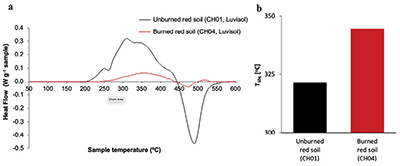 |
| Figure 5. Thermogravimetry analysis (TGA) curves and differential scanning calorimetry (DSC) parameter T50q (Temperature when the 50 % of the energy is released) from the red soils from Chiapas (unburned and burned Luvisols). |
3.2. Soil characteristics in ancient burning site at Coyote Quarry
3.2.1. Macromorphological characteristics
The Selva-depresión profile was found beneath jungle vegetation in a depression. It measures 30 cm thick and comprises three different types of horizons: O, A, and AC (Figure 6a, 6b). The O horizon (0–4 cm) consisted of leaves, branches, and roots that decreased in size with depth. The A (4–14 cm) and AC horizons (14–30 cm) were dark brown with a granular structure and a high root density. The percentage of rock fragments is more than 50%, being more abundant in the AC horizon. At the bottom of the profile, a 1 cm clay layer was in direct contact with the limestone.
The Negra Gorda profile was in a modern soil karstic pocket constituted by Ah, AB1, and AB2 horizons (Figure 6c, 6d). The Ah horizon (0–30 cm) showed a dark brown color, a granular structure, high root density, and high content of limestone fragments. The AB1 (30–70 cm) and AB2 horizons (70–100 cm) exhibited a very dark brown-reddish color, less content of rock fragments and abundant Fe-Mn concretions.
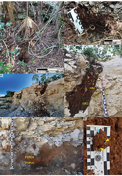 |
| Figure 6. Coyote Quarry sampling sites. a) Selva-depresión landscape and b) soil profile. c) Coyote Quarry west wall with d) Negra Gorda soil karstic pocket. e) Collapsed cave with PSOP1 and PSOP2 pedosediments. f) Pedosediment from the collapsed cave, yellow arrows indicate charcoal fragments and the blue arrow a burned shell fragment. Photos by Sergey Sedov and Jaime Díaz. |
The pedosediments from the collapsed cave (PSPO1 & PSPO2) were dark reddish brown (Figure 6e). They showed a mix of clay material, broken terrestrial shells, some charcoals, and limestone fragments (gravel size) frequently charred. Both exhibited a strong reaction to HCl. PSPO1 contained roots and was looser and less dense than PSPO2, which was more compact and contained abundant charred shells and burned limestone fragments.
3.2.2. Micromorphological features
The A horizon at Selva-depresión showed a clay-reddish groundmass with a granular structure composed of rounded and subangular aggregates. Some aggregates were pigmented with humus (Figures 7a, 7b). Fresh vegetal remains, shell fragments, small limestone grains, and iron nodules were identified. The three horizons of the Negra Gorda pocket also exhibited a clayey-reddish groundmass with a granular to subangular blocky structure. The vegetal remains were common and were fresh or decomposed at different levels or even with coprolite infillings. Different-sized anorthic Fe nodules were abundant in the entire profile; they were dispersed in the groundmass. In the Ah horizon, few carbonate fragments were detected. Charcoal fragments were common in the AB1 horizon (Figure 7c). In both AB1 and AB2 horizons, rounded black soil fragments were common (Figure 7d), with a mean size of 2 cm in diameter; besides these black fragments, reddish or dark brown soil fragments were also present, in most cases fractured.
The micromorphological analysis revealed that pedosediments (PSPO1 & PSPO2) from the collapsed cave were a mixture of clayey-reddish soil material with a sub-angular blocky structure, abundant burned shells (Figure 7f), rounded-reddish soil fragments (see Figure 7h in Sedov et al., 2023), and abundant limestone fragments, which exhibited rounded or angular shapes. Most of these rocks were charred, showing a dark black color using plane-polarized light, and recrystallized calcite crystals with a triangular shape seen by cross-polarized light (Figure 7e).
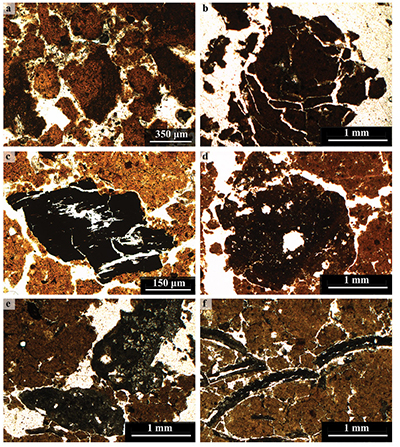 |
| Figure 7. Micromorphological features of soil and pedosediments of Coyote Quarry. a) Granular structure with a clay-reddish groundmass and some aggregates are pigmented with humus (darker color) and b) a clay-rich subangular aggregate from Selva-depresión Ah horizon. c) Charcoal fragment and d) dark pedosediments into the soil clayey matrix of the AB1 horizon in Negra Gorda profile. e) Charred limestones fragments and f) burned shells in the PSPO2 pedosediments. |
3.2.3. Physical and chemical characteristics
The soil texture of the Selva-depresión profile was very clayey, and both horizons (A and AC) exhibited almost the same particle size distribution, with more than 94% clay, about 5% silt, and only 0.2% sand (Figure 8). Horizons of the Negra Gorda karstic pocket showed a clayey texture, where the clay fraction was up to 55.8% in the Ah horizon (which has a high percentage of silt 43.3%) and more than 90 % in both AB horizons (Figure 8). Sand fraction was less than 3.5 % in the whole profile. The cave pedosediments (PSPO1 & PSPO2) exhibited a more heterogeneous texture. They contained mainly clay 74.6–87%, 3–18.2% of silt, and 7.2–10 % of sand (Figure 8). However, these materials showed a slightly higher portion of sand than the other soil profiles studied in the Coyote Quarry.
According to soil color measurements of the Selva-drepresión profile, the A horizon was more luminous, slightly more reddish, and slightly more yellowish than the AC horizon. The soil color of the Negra Gorda profile was similar for its three horizons. For the pedosediments in the cave, these two materials showed a higher luminosity value than the previous soil profiles, whereas the redness and yellowness exhibited slightly higher values (Figure 8).
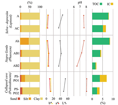 |
| Figure 8. Physical-chemical characteristics of soil and pedosediments from Coyote Quarry. From left to right: texture, color parameters (a*, b*, and L*), pH, total organic carbon and inorganic carbon. |
The pH of the Selva-depresión and the Negra Gorda soil profiles was near to neutrality condition, meanwhile, the pedosediments in the collapsed cave showed a basic pH with values between 8.1–8.0 (Figure 8).
In the Selva-depresión and in the Negra Gorda profiles, the TOC content was greater in the Ah horizons than in the lower horizons (Figure 8). In contrast, the IC content was higher for the AC horizon in the Selva-depresión, while in the Negra Gorda, the content was low in the whole profile. The collapsed cave pedosediments showed similar proportions of IC and TOC.
3.2.4. Thermal analysis
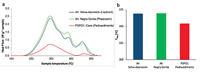
The TGA curves behavior for the Ah soil horizons from the Selva-drepresión and Negra Gorda profiles were similar, but they differ in relation to the cave pedosediments PSPO1 curve (Figure 9a). The Selva-depresión and Negra Gorda curves exhibited three different exothermic peaks around 350º C, 430 ºC, and 515 ºC. The higher proportion of organic compounds corresponded to thermo-labile organic matter, represented by the largest area below the curves (200–375 ºC). On the other hand, the TGA curve for the cave pedosediments PSPO1 only exhibited two exothermic peaks, at 346 ºC and 510 ºC, with lower areas below the curve than the previous one. In this case, similar to the other two samples, the thermo-labile organic matter represented the higher proportion of the organic compounds. In contrast, the thermo-recalcitrant and highly-recalcitrant compounds were present but in a lower proportion. Regarding the thermal parameter T50q (Figure 9b), Ah soil horizons from the Selva-depresión and Negra Gorda profiles showed higher T50q values (around 370 ºC) than the cave pedosediments PSPO1 with a T50q value of 354 ºC.
3.2.5. Radiocarbon dates
The radiocarbon date of the AB1 soil horizon in the Negra Gorda profile was 750 +/- 40 BP (uncalibrated age; Table 1). In contrast, the charcoals and terrestrial mollusks from PSPO1 dates varied between 3530 to 3850 +/- 40 BP (uncalibrated ages; Table 1).
- Discussion
4.1. Fire effects on Chiapas soils as a reference of a recent burning
The slash-and-burn practices might strongly affect soil properties (Santín and Doerr, 2016), as shown in Chiapas burned samples. The changes observed there correspond to unequivocal fire effects: a) the darkening of the topsoil due to the incomplete combustion of organic materials allowing charcoal formation, and the TOC decrease in the mineral soil due to organic matter volatilization in form of CO2 (Giovannini et al., 1988; Ketterings and Bigham, 2000; Badía and Martí, 2003); b) the intense reddening of the red soil (Figure 2) attributed to the mineralogical transformation of iron oxides at high temperatures (>600ºC) causing the change in soil matrix color (Ulery and Graham, 1993; Ketterings et al., 2000; Ketterings and Bigham, 2000); c) the high increase of sand fraction (Figure 4) attributed to the thermal fusion of clay particles and transformation of Fe and Al oxyhydroxides of mineral compounds during severe burnings (>500 ºC), generated sand-sized clayey aggregates with very high stability (Ulery and Graham, 1993; Ketterings et al., 2000; Certini, 2005; Mataix-Solera et al., 2011; Santín and Doerr, 2016); d) the increment of IC and pH (Figure 4) due to the complete combustion of biomass at high temperatures that transform plants calcium oxalate into calcium carbonates which are the main components of ashes accompanied by high contents of Ca, Mg, and K (Ulery et al., 1993; Arocena and Opio, 2003; Canti and Brochier, 2017; Agbeshie et al., 2022). On the other hand, the quality of the organic matter changes with the increase in temperature (Knicker et al., 2008). In the Chiapas unburned red soil sample, the TGA and DSC analyses reveal a modification of soil organic matter recalcitrance after the slash and burn events. In addition, the unburned red soil endothermic peak at 475 ºC (Figure 5), can be associated with the kaolinite content in the sample, which is transformed at higher temperatures, which explains the lower endothermic peak observed in the burned red soil (Figure 5). This probably results from unprotected mineral fraction by organic matter (already charred and eroded). Thus, minerals are more susceptible to the effects of high temperatures during burning.
The morphological features, observed in both macro and micro scales, are also relevant as several changes are detected after burning. These changes are related to the structure, where the size and consistency of subangular blocky aggregates diminish (Figures 2, 3e, 3f), and the redness of the groundmass with the presence of ashes, charcoal fragments, and rhomboidal calcite crystals (Figures 3c, 3d). Similar changes were reported in a prescribed fire by Moreno-Roso et al. (2023) in areas with a high soil burn severity.
 |
| Figure 9. Thermogravimetry analysis (TGA) curves and differential scanning calorimetry (DSC) parameter T50q (Temperature when the 50 % of the energy is released) from the soils and pedosediments of Coyote Quarry. |
On the other hand, using the observed organic matter thermal modifications in the soils from Chiapas as a model to identify the transformations in the Coyote Quarry materials, we suggest that the T50q parameter (Figure 9b) results in temperature values between 350-370 ºC that are even higher than those of the Chiapas red burned soil, associated to the presence of organic matter with a major energy release (Merino et al., 2015). Additionally, the TGA curves of soils and pedosediments in the Coyote Quarry show the presence of an exothermic peak (around 510–515 ºC) inside the highly recalcitrant organic matter zone (Figure 9a). These results can be associated with pyrogenic carbon remains in the soils and pedosediments from ancient burning events in the area. However, the dominance of thermo-labile organic matter in the TGA curves can also be explained by the incorporation of different pedosediments and new soil organic matter along the time in conjunction with the regeneration of the tropical forest vegetation after the ancient burning. These are common processes in a dynamic karstic landscape where soil and pedosediments constantly change due to pedoturbations. Consequently, the TGA and DSC analyses support the existence of fire signals within the karstic depressions and the cave resulting from eroded soils affected by past burning events.
4.2 Evidence of ancient burnings in the karstic zone of Quintana Roo: How did the ancient Mayas affect the landscape?
Although the slash-and-burn practice is considered a “controlled fire,” the effects on Chiapas soils were heterogeneous, resulting in patches with different soil burn severities (SBS). These different SBS result from the environmental variations and fire characteristics in the same burned area (Hubbert et al., 2006; Girona-García et al., 2019). Therefore, SBS is determined by several factors such as vegetation type and characteristics, soil type, soil moisture, soil structure, soil organic matter, landscape geomorphology, fire intensity (related to the energy release and temperature), fire residence time (heating duration), and atmospheric conditions (DeBano et al., 1998; Neary et al., 1999; Certini, 2005; Doerr and Cerdà, 2005; Badía et al., 2017; Doerr et al., 2023). Another variable that might influence fire impacts on soil is the burning execution. Slash-and-burn shifting cultivation techniques can vary from culture to culture or even inside the same Maya culture over time. For example, Night and Diemont (2013) indicated differences between traditional Maya and contemporaneous slash-and-burn practices in the Maya area. Meanwhile, the latter requires an annual “hot burn,” in the traditional system, low-intensity burns in small areas of the field are occasionally induced throughout the year, generating charcoal and ashes, which increase soil fertility and preserve organic matter. The “hot burn” is performed only once in 25 years over the entire field (Night and Diemont, 2013). On the other hand, Thomaz et al. (2014) mentioned that higher quantities of fuels are accumulated during longer fallow periods; slash-and-burn practice leaves the fuel closer to the topsoil, raising the heat transfer and the impact on the soil. Therefore, in a geoarchaeological context, it is difficult to know all these conditions at the moment of the burning. However, favored by soil memory, we have traces of ancient burnings from which we can infer fire effects on soils and estimate some of these conditions.
Most of the fire evidence produced after slash-and-burn in Chiapas soils cannot be permanent over time; most of the features are erased and overlapped by natural and anthropogenic processes, such as pedogenesis, erosion, and changes on slash-and-burn regimes (DeBano et al., 1998; Dussol et al., 2021), especially in these dynamic and heterogeneous tropical karstic systems, where the land cover is considered to have a reduced soil memory (Sedov et al., 2023). Additionally, this landscape has been used and modified by humans in different historical periods. However, karstic depressions are outstanding sinkholes for burned features preservation in soils from this kind of environment (Cabadas-Báez et al., 2010; Sedov et al., 2023). Therefore, we found well-preserved macroscopic and microscopic charcoals, burned shells, and charred limestones in soils and pedosediments deposits at the Coyote Quarry (Figures 7c, 7d, 7e, 7f). Actually, micro-charcoals in different environments have been used as evidence of local fires as in agricultural soils in Russia (Mergelov et al., 2020), France (Carcaillet, 1998; Ponomarenko et al., 2019), and lacustrine systems in the Mexican Caribbean coast (Correa-Metrio et al., 2023). Although the reduced soil memory of the karstic pedogenetic records, the use of micromorphology in the study of burned features in conjunction with radiocarbon dates offers information about anthropogenic influence on the environment such as in other archaeological contexts (Mallol et al., 2007; Huisman et al., 2019; Sedov et al., 2023).
The radiocarbon date of soil inside the modern karstic pocket, Negra Gorda profile, corresponds to the Late Classic period of Maya culture history (Table 1). In contrast, dates obtained from the terrestrial mollusk and charcoals from PSPO1 (Table 1) in the collapsed cave correspond to the limit between the Archaic and Pre-Classic periods (Sedov et al., 2023). Our finding of charcoals directly associated with burned shells and charred rocks implies the occurrence of anthropogenic burnings in the region. We correlate this fire evidence to the start of slash-and-burn practices by Mayas (Brenner et al., 2003). The huge pressure applied by this civilization on this delicate environment triggered extensive soil erosion throughout the region; however, in the Pre-Classic period, the most intense anthropogenic erosion occurred (Brenner et al., 2002; Beach et al., 2015; Dunning et al., 2023).
The lateral soil movement is the most common erosive process in the mountainous areas (Sedov et al., 2008). In contrast, the vertical soil movement, or “soil piping,” is the dominant direction of erosional processes in this northern part of the Maya region, controlled by the geomorphology of a karstic platform with a high occurrence of vertical dissolution fissures (Sedov et al., 2008; White and Culver, 2012; Sedov et al., 2023). The presence of charcoal fragments, burned shells, and charred rocks of centimetric size on these karstic depressions confirms the piping process because vertical transportation of charcoals >1–2 mm is usually limited (Carcaillet and Thinon, 1996; Tinner et al., 2006; Mergelov et al., 2020). Therefore, it is highly possible that these charred materials came from a nearby burned site (Tinner et al., 2006; Mergelov et al., 2020) or directly from the surface above the cave (Sedov et al., 2023). The surface soils in the quarry (Selva-depresión profile) and in the karstic pocket (Negra Gorda) show the presence of micro-charcoals (Fig. 7c), which indicate the effects of previous fires. Micro-charcoals found in the karstic depressions at the Coyote Quarry resulted from the mechanical fragmentation during transportation and post-depositional processes of larger charcoal particles (Chrzazvez et al., 2014). In contrast to macro-charcoals, micro-charcoals vertical movement is dominated by soil structure and porosity, and their low concentration in soil can be related to a few or only one burn event or to easier removal of these smaller charcoal fragments (Chrzazvez et al., 2014; Dussol et al., 2021). Micro-charcoals can travel long distances and are deposited in lacustrine sediments, offering regional and local fire history context (Clark, 1988; Magne et al., 2019). Furthermore, our findings directly correlate with lacustrine micro-charcoals records and palynological archives from other studies (Brenner et al., 2002; Schüpbach et al., 2015; Correa-Metrio et al., 2023). For example, Correa-Metrio et al. (2023) found in the charcoal record of La Encantada lagoon, near the Bay of Chetumal (in the Mexican Maya Lowlands), evidence of high-frequency local fire events from 5200 to 2700 cal yr. BP and an increase of palynological taxa linked with anthropic activities. Thus, they associated these records with the beginning of burning for landscape transformation in the area.
According to pollen records and the thick unit of clay combined with sediment layers with a high organic content in Maya Lowlands lakes, a tropical forest loss started during the Early and Middle Pre-Classic when Maya people began their development across the Yucatán Peninsula more than 3000 14C year BP (Brenner et al., 2002). Besides, other authors (Beach et al., 2015) indicate that these environmental changes had a direct relationship with Maya burnings. However, other regional paleo-climatic studies also found a dry period that started 3000 years ago, and this signal can overlap the anthropic effect (Brenner et al., 2002). Likewise, Schüpbach et al. (2015) detected a peak of fire activity at 3700 cal years BP from the study of lacustrine charcoal sediment and molecular fire proxies in the Maya lowlands of Petén, Guatemala, related to early agricultural activities but the authors did not exclude the possible influence of the dry climate conditions on vegetation ignition. Our findings agree with Piperno (2006) paleo-ecological research, which found that slash-and-burn practices near to the southwest Mexico lowlands forest began in the Late Archaic period (4000 years BP). Therefore, our evidence of early burning events can be associated with Maya land cultivation beginning in the Yucatán Peninsula.
- Conclusions
This study of the impact of slash-and-burn agriculture in Chiapas can be used as a model of how a recent burning transforms specific soil properties. After the burning, the following changes were detected: darkening of the topsoil observed in the field, in the laboratory, and under the microscope; reddening of the clayey groundmass, also confirmed by colorimetric methods; formation of bigger red-clayey aggregates. Likewise, in thin sections, ashes were frequent and commonly filling pores, as well as a few charcoal fragments. According to physical-chemical analyses, soils showed a high increase in the sand fraction due to the formation of bigger red-clayey aggregates, a decrease in the TOC content, and an increase in pH and IC.
Soils and pedosediments studied in Yucatán, as an ancient human impact case, gave interesting results. This warm and humid karstic landscape has been occupied and modified for thousands of years. Anthropic, sedimentary, and pedogenetic processes have caused pedoturbation in the region. However, as demonstrated in this and other studies, karstic sinkholes represent an outstanding reservoir for eroded surficial soils (pedosediments) and stable burned features such as charcoals, burned shells, and charred limestone fragments. The association of these burned materials and their radiocarbon dates led us to relate this evidence to the beginning of slash-and-burn agriculture by Mayas in the Yucatán Peninsula between the Archaic and the Early Pre-Classic periods. Nevertheless, more work is needed to search these burned features inside other karstic depressions and into soils affected by recent burning at the Yucatán Peninsula to reconstruct the early Maya burning history and support this soil record with other paleoenvironmental proxies.
Authors contributions
Conceptualization: Sedov, S., Solleiro-Rebolledo, E.; Data analysis or acquisition: Sedov, S., Solleiro-Rebolledo, E., Moreno-Roso, S., Chávez-Vergara, B., Merino, A.; Methodological/technical development: Moreno-Roso, S., Chávez-Vergara, B.; Drafting the original manuscript: Moreno-Roso, S.; Drafting the corrected and edited manuscript: Moreno-Roso, S., Solleiro-Rebolledo, E., Sedov, S., Chávez-Vergara, B., Merino, A.; Graphic design: Moreno-Roso, S.; Fieldwork: Sedov, S., Solleiro-Rebolledo, E.; Interpretation: Moreno-Roso, S., Solleiro-Rebolledo, E., Sedov, S., Chávez-Vergara, B., Merino, A.; Funding: Sedov, S.
Funding
This work has been funded by UNAM PAPIIT, Project IN108622, “Rendzic Leptosols of the karstic geosystems in southern Mexico: Genesis and evolution in relation to the natural and anthropic landscape change” (S. Sedov). SM-R acknowledges the CONAHCYT Scholarship (Nº 863828).
Acknowledgments
We highly appreciate the work done by Jaime Díaz, René Alcalá, Ofelia Beltrán, Arturo Atilano, Silvia Martínez, Veronica Piñeiro, Eva Seijas, Daisy Valera, Héctor Cabadas-Baéz, Araceli Bohorquez, Aldo, and Iván.
Conflict of interest
The authors declare that this research was conducted in the absence of any commercial or financial relationships that could be construed as a potential conflict of interest.
Handling editor
Avto Goguitchaichvili.
References
Abney, R.B., Berhe, A.A., 2018, Pyrogenic carbon erosion: implications for stock and persistence of pyrogenic carbon in soil: Frontiers in Earth Science, 6, 1–16. https://doi.org/10.3389/feart.2018.00026
Agbeshie, A.A., Abugre, S., Atta-Darkwa, T., Awuah, R., 2022, A review of the effects of forest fire on soil properties: Journal of Forestry Research, 33(5), 1419–1441. https://doi.org/10.1007/s11676-022-01475-4
Alcañiz, M., Outeiro. L., Francos, M., Úbeda, X., 2018, Effects of prescribed fires on soil properties: A review: Science of The Total Environment, 613-614, 944-957. https://doi.org/10.1016/j.scitotenv.2017.09.144
Alperson-Afil, N., 2012, Archaeology of fire: methodological aspects of reconstructing fire history of prehistoric archaeological sites: Earth-Science Reviews, 113(3–4), 111–119. https://doi.org/10.1016/j.earscirev.2012.03.012
Andrade-Velázquez, M., Medrano-Pérez, O.R., 2020, Precipitation patterns in Usumacinta and Grijalva Basins (southern Mexico) under a changing climate: Revista Bio Ciencias, 7, 1–22. https://doi.org/10.15741/revbio.07.e905
Andreani, L., Gloaguen, R., 2016, Geomorphic analysis of transient landscapes in the Sierra Madre de Chiapas and Maya Mountains (northern Central America): implications for the North American-Caribbean-Cocos plate boundary: Earth Surface Dynamics, 4(1), 71–102. https://doi.org/10.5194/esurf-4-71-2016
Arocena, J.M., Opio, C., 2003, Prescribed fire-induced changes in properties of sub-boreal forest soils: Geoderma, 113(1–2), 1–16. https://doi.org/10.1016/S0016-7061(02)00312-9
Arroyo-Kalin, M., 2012, Slash-burn-and-churn: landscape history and crop cultivation in pre-Columbian Amazonia: Quaternary International, Long-term perspectives on human occupation of tropical rainforests, 249, 4–18. https://doi.org/10.1016/j.quaint.2011.08.004
Badía, D., López-García, S., Martí, C., Ortíz-Perpiñá, O., Girona-García, A., Casanova-Gascón, J., 2017, Burn effects on soil properties associated to heat transfer under contrasting moisture content: Science of The Total Environment, 601–602, 1119–1128. https://doi.org/10.1016/j.scitotenv.2017.05.254
Badía, D., Martí, C., 2003, Plant ash and heat intensity effects on chemical and physical properties of two contrasting soils: Arid Land Research and Management, 17(1), 23–41. https://doi.org/10.1080/15324980301595
Barros, N., Salgado, J., Villanueva, M., Rodriquez-Añón, J., Proupin, J., Feijóo, S., Martín-Pastor, M., 2010, Application of DSC–TG and NMR to study the soil organic matter: Journal of Thermal Analysis and Calorimetry, 104(1), 53–60. https://doi.org/10.1007/s10973-010-1163-4
Beach, T., Luzzadder-Beach, S., Cook, D., Dunning, N., Kennett, D J., Krause, S., Terry, R., Trein, D., Valdez, F., 2015, Ancient Maya impacts on the Earth’s surface: an early Anthropocene analog?: Quaternary Science Reviews, 124, 1–30. https://doi.org/10.1016/j.quascirev.2015.05.028
Bowman, D.M.J.S., O’Brien, J.A., Goldammer, J.G., 2013, Pyrogeography and the global quest for sustainable fire management: Annual Review of Environment and Resources, 38(1), 57–80. https://doi.org/10.1146/annurev-environ-082212-134049
Brenner, M., Hodell, D.A., Curtis, J.H., Rosenmeier, M.F., Anselmetti, F.S., Ariztegui, D., 2003, Paleolimnological approaches for inferring past climate change, in The Maya Region: recent advances and methodological limitations, The Lowland Maya Area: New York, New York, United States of America (USA), Food Products, 45–75.
Brenner, M., Rosenmeier, M.F., Hodell, D.A., Curtis, J.H., 2002, Paleolimnology of the Maya lowlands: long-term perspectives on interactions among climate, environment, and humans: Ancient Mesoamerica, 13(1), 141–157. https://doi.org/10.1017/S0956536102131063
Cabadas-Báez, H., Solleiro-Rebolledo, E., Sedov, S., Pi-Puig, T., Gama-Castro, J., 2010, Pedosediments of karstic sinkholes in the eolianites of NE Yucatán: a record of Late Quaternary soil development, geomorphic processes and landscape stability: Geomorphology, Reconstruction of landscape change in Quaternary environments, 122(3-4), 323–337. https://doi.org/10.1016/j.geomorph.2010.03.002
Cancelo-González, J., Cachaldora, C., Díaz-Fierros, F., Prieto, B., 2014, Colourimetric variations in burnt granitic forest soils in relation to fire severity: Ecological Indicators, 46, 92–100. https://doi.org/10.1016/j.ecolind.2014.05.037
Canti, M.G., Brochier, J.É., 2017, Plant Ash, in Nicasio, C., Stoops, G. (eds.), Archaeological Soil and Sediment Micromorphology: Hoboken, New Jersey, John Wiley & Sons, Ltd, 147–154. https://doi.org/10.1002/9781118941065.ch17
Carcaillet, C., 1998, A spatially precise study of Holocene fire history, climate and human impact within the Maurienne valley, North French Alps: Journal of Ecology, 86(3), 384–396. https://doi.org/10.1046/j.1365-2745.1998.00267.x
Carcaillet, C., Thinon, M., 1996, Pedoanthracological contribution to the study of the evolution of the upper treeline in the Maurienne valley (North French Alps): methodology and preliminary data: Review of Palaeobotany and Palynology, 91(1), 399–416. https://doi.org/10.1016/0034-6667(95)00060-7
Certini, G., 2005, Effects of fire on properties of forest soils: A review: Oecologia, 143(1), 1–10. https://doi.org/10.1007/s00442-004-1788-8
Chrzazvez, J., Théry-Parisot, I., Fiorucci, G., Terral, J.F., Thibaut, B., 2014, Impact of post-depositional processes on charcoal fragmentation and archaeobotanical implications: experimental approach combining charcoal analysis and biomechanics: Journal of Archaeological Science, 44, 30–42. https://doi.org/10.1016/j.jas.2014.01.006
Commission Internationale de l’Eclairage (CIE), 1986, Colorimetry. 2nd Edition, Publication CIE No. 15.2, Commission Internationale de l’Eclairage, Vienna.
Clark, J.D., Harris, J.W.K., 1985, Fire and its roles in early hominid lifeways: African Archaeological Review, 3(1), 3–27. https://doi.org/10.1007/BF01117453
Clark, J.S., 1988, Particle motion and the theory of charcoal analysis: source area, transport, deposition, and sampling: Quaternary Research, 30(1), 67–80. https://doi.org/10.1016/0033-5894(88)90088-9
Correa-Metrio, A., Cordero-Oviedo, C., Gámez-Núñez, E., Olivares-Casillas, G., Escobar, J., Curtis, J.H., Pérez, L., Blaauw, M., Bernal, J.P., 2023, The evolution of the Maya coastal landscape in the Mexican Caribbean during the last 6200 years: Quaternary Science Reviews, 314, 108-214. https://doi.org/10.1016/j.quascirev.2023.108214
DeBano, L.F., Neary, D.G., Ffolliott, P.F., 1998, Fire’s effects on ecosystems: New York, J. Wiley, 333 p.
Dell’Abate, M.T., Benedetti, A., Trinchera, A., Dazzi, C., 2002, Humic substances along the profile of two Typic Haploxerert: Geoderma, 107(3), 281–296. https://doi.org/10.1016/S0016-7061(01)00153-7
Dietze, E., Theuerkauf, M., Bloom, K., Brauer, A., Dörfler, W., Feeser, I., Feurdean, A., Gedminienė, L., Giesecke, T., Jahns, S., Karpińska-Kołaczek, M., Kołaczek, P., Lamentowicz, M., Latałowa, M., Marcisz, K., Obremska, M., Pędziszewska, A., Poska, A., Rehfeld, K., Stančikaitė, M., Stivrins, N., Święta-Musznicka, J., Szal, M., Vassiljev, J., Veski, S., Wacnik, A., Weisbrodt, D., Wiethold, J., Vannière, B., Słowiński, M., 2018, Holocene fire activity during low-natural flammability periods reveals scale-dependent cultural human-fire relationships in Europe: Quaternary Science Reviews, 201, 44–56. https://doi.org/10.1016/j.quascirev.2018.10.005
Doerr, S.H., Cerdà, A., 2005, Fire effects on soil system functioning: new insights and future challenges: International Journal of Wildland Fire, 14(4), 339–342. https://doi.org/10.1071/WF05094
Doerr, S.H., Santín, C., Mataix-Solera, J., 2023, Fire effects on soil, in Goss, M.J., Oliver, M. (eds.), Encyclopedia of Soils in the Environment (Second Edition), Oxford, Academic Press, 448–457. https://doi.org/10.1016/B978-0-12-822974-3.00106-3
Dunning, N.P., Beach, T., Cook, D., Luzzadder-Beach, S., 2023, Maya Lowlands: geoarchaeological perspectives on environmental change, in Gilbert, A.S., Goldberg, P., Mandel, R.D., Aldeias, V. (eds.), Encyclopedia of Geoarchaeology, Encyclopedia of Earth Sciences Series: Cham, Germany, Springer International Publishing, 1–10. https://doi.org/10.1007/978-3-030-44600-0_265-2
Dussol, L., Vannière, B., Purdue, L., Orange, F., Testé, M., Castanet, C., Garnier, A., Lemonnier, E., Théry-Parisot, I., 2021, How to highlight slash-and-burn agriculture in ancient soils? A modern baseline of agrarian fire imprint in the Guatemalan lowlands using charcoal particle analysis: Journal of Archaeological Science: Reports, 35, 102725. https://doi.org/10.1016/j.jasrep.2020.102725
Eckmeier, E., Gerlach, R., Skjemstad, J.O., Ehrmann, O., Schmidt, M.W.I., 2007a, Only small changes in soil organic carbon and charcoal concentrations found one year after experimental slash-and-burn in a temperate deciduous forest: Biogeosciences Discussions, 4(1), 595–614. https://doi.org/10.5194/bgd-4-595-2007
Eckmeier, E., Rösch, M., Ehrmann, O., Schmidt, M.W.I., Schier, W., Gerlach, R., 2007b, Conversion of biomass to charcoal and the carbon mass balance from a slash-and-burn experiment in a temperate deciduous forest: Holocene, 17(4), 539–542. https://doi.org/10.1177/0959683607077041
Espinasa-Pereña, R., 2007, El Karst de México. Mapa NA III 3, en Coll-Hurtado, A. (coord.), Nuevo Atlas Nacional de México: México, Universidad Nacional Autónoma de México, Instituto de Geografía.
Faust, B.B., 2001, Maya environmental successes and failures in the Yucatán Peninsula: Environmental Science & Policy, 4(4-5), 153–169. https://doi.org/10.1016/S1462-9011(01)00026-0
Fernández, J.M., Plante, A.F., Leifeld, J., Rasmussen, C., 2011, Methodological considerations for using thermal analysis in the characterization of soil organic matter: Journal of Thermal Analysis and Calorimetry, 104(1), 389–398. https://doi.org/10.1007/s10973-010-1145-6
Flores-Delgadillo, L., Alcalá-Martínez, J.R., 2010, Manual de procedimientos analíticos, laboratorio de física de suelos: Universidad Nacional Autónoma de México, Instituto de Geología, Departamento de Edafología, 56 p.
Fragoso-Servón, P., Pereira-Corona, A., Bautista, F., 2019, The karst and its neighbors: digital map of geomorphic environments in Quintana Roo, México: Journal of Cave and Karst Studies, 81, 113–122. https://doi.org/10.4311/2018ES0112
García, E., 2004, Modificaciones al Sistema de Clasificación Climática de Köppen, 5th ed: México, Universidad Nacional Autónoma de México, Instituto de Geografía, 90 p.
Garcia-Molina, G., 1994, Structural evolution of SE Mexico (Chiapas-Tabasco-Campeche) offshore and onshore: Texas, United States, Rice University, PhD dissertation, 161 p.
Garduño-Monroy, V.H., Macías, J.L., Molina-Garza, R.S., 2015, Geodynamic setting and pre-volcanic geology of active volcanism in chiapas, in Scolamacchia, T., Macías, J.L. (eds.), Active Volcanoes of Chiapas (Mexico): El Chichón and Tacaná, Active Volcanoes of the World: Berlin, Heidelberg, Springer Berlin Heidelberg, 1–23. https://doi.org/10.1007/978-3-642-25890-9_1
Giovannini, G., Lucchesi, S., Giachetti, M., 1988, Effect of heating on some physical and chemical parameters related to soil aggregation and erodibility: Soil Science, 146(4), 255–261.
Girona-García, A., Badías-Villas, D., Jiménez-Morillo, N.T., González-Pérez, J.A., 2019, Changes in soil organic matter composition after Scots pine afforestation in a native European beech forest revealed by analytical pyrolysis (Py-GC/MS): Science of The Total Environment, 691, 1155-1161. https://doi.org/10.1016/j.scitotenv.2019.07.229
González, A.H., Sandoval, C.R., Mata, A.T., Sanvicente, M., Acevez, E., 2008, The Arrival of Humans on the Yucatán Peninsula: Evidence from Submerged Caves in the State of Quintana Roo, Mexico: Current Research in the Pleistocene, 25, 1–22.
Gowlett, J.A.J., 2016, The discovery of fire by humans: a long and convoluted process: Philosophical Transactions of the Royal Society B: Biological Sciences, 371(1696), 20150164. https://doi.org/10.1098/rstb.2015.0164
Gowlett, J.A.J., Harris, J.W.K., Walton, D., Wood, B.A., 1981, Early archaeological sites, hominid remains and traces of fire from Chesowanja, Kenya: Nature, 294(5837), 125–129. https://doi.org/10.1038/294125a0
Hering, F., Stinnesbeck, W., Folmeister, J., Frey, E., Stinnesbeck, S., Avilés, J., Aceves-Núñez, E., González, A., Terrazas-Mata, A., Benavente, M.E., Rojas, C., Velázquez-Morlet, A., Frank, N., Zell, P., Becker, J., 2018, The Chan Hol cave near Tulum (Quintana Roo, Mexico): evidence for long-lasting human presence during the early to middle Holocene: Journal of Quaternary Science, 33(4), 444–454. https://doi.org/10.1002/jqs.3025
Hobley, E.U., Le Gay Brereton, A.J., Wilson, B., 2017, Forest burning affects quality and quantity of soil organic matter: Science of The Total Environment, 575, 41-49. https://doi.org/10.1016/j.scitotenv.2016.09.231
Hubbert, K.R., Preisler, H.K., Wohlgemuth, P.M., Graham, R.C., Narog, M.G., 2006, Prescribed Burning Effects on Soil Physical Properties and Soil Water Repellency in a Steep Chaparral Watershed, Southern California, USA: Geoderma 130, 284–298. https://doi.org/10.1016/j.geoderma.2005.02.001
Huffman, E.W.D., 1977, Performance of a new automatic carbon dioxide coulometer: Microchemical Journal, 22(4), 567–573. https://doi.org/10.1016/0026-265X(77)90128-X
Huisman, D.J., Niekus, M.J., Peeters, J.H., Geerts, R.C., Müller, A., 2019, Deciphering the complexity of a ‘simple’ mesolithic phenomenon: Indicators for construction, use and taphonomy of pit hearths in Kampen (the Netherlands): Journal of Archaeological Science, 109, 1–12. https://doi.org/10.1016/j.jas.2019.104987
Instituto Nacional de Estadística y Geografía (INEGI), 2007a, Carta edafológica serie II Tenosique E15-9:, escala 1:250 000, México, Instituto Nacional de Estadística y Geografía, 1 mapa.
Instituto Nacional de Estadística y Geografía (INEGI), 2007b, Carta edafológica serie II Cozumel F16-11:, escala 1:250 000, México, Instituto Nacional de Estadística y Geografía, 1 mapa.
Instituto Nacional de Estadística y Geografía (INEGI), 2019a, Carta de uso del suelo y vegetación serie VI Tenosique E15-9:, escala 1:250 000, México, Instituto Nacional de Estadística y Geografía, 1 mapa.
Instituto Nacional de Estadística y Geografía (INEGI), 2019b, Carta de uso del suelo y vegetación serie VI Cozumel F16-11:, escala 1:250 000, México, Instituto Nacional de Estadística y Geografía, 1 mapa.
James, S.R., Dennell, R.W., Gilbert, A.S., Lewis, H.T., Gowlett, J.A.J., Lynch, T.F., McGrew, W.C., Peters, C.R., Pope, G.G., Stahl, A.B., 1989, Hominid use of fire in the Lower and Middle Pleistocene: a review of the evidence [and Comments and Replies]: Current Anthropology, 30(1), 1–26. https://www.jstor.org/stable/2743299
Johnson, K.D., Terry, R.E., Jackson, M.W., Golden, C., 2007, Ancient soil resources of the Usumacinta River Region, Guatemala: Journal of Archaeological Science, 34(7), 1117–1129. https://doi.org/10.1016/j.jas.2006.10.004
Jones, J.G., 1994, Pollen evidence for early settlement and agriculture in northern Belize: Palynology, 18, 205–211. https://www.jstor.org/stable/3687764
Ketterings, Q.M., Bigham, J.M., 2000, Soil color as an indicator of slash-and-burn fire severity and soil fertility in Sumatra, Indonesia: Soil Science Society of America Journal, 64(5), 1826–1833. https://doi.org/10.2136/sssaj2000.6451826x
Ketterings, Q.M., Bigham, J.M., Laperche, V., 2000, Changes in soil mineralogy and texture caused by slash-and-burn fires in Sumatra, Indonesia: Soil Science Society of America Journal, 64(3), 1108–1117. https://doi.org/10.2136/sssaj2000.6431108x
Knicker, H., 2023, Black carbon, pyrogenic carbon, in Goss, M.J., Oliver, M. (eds.), Encyclopedia of Soils in the Environment (Second Edition): Oxford, Academic Press, 432–447. https://doi.org/10.1016/B978-0-12-822974-3.00201-9
Knicker, H., Hilscher, A., González-Vila, F.J., Almendros, G., 2008, A new conceptual model for the structural properties of char produced during vegetation fires: Organic Geochemistry, 39(8), 935–939. https://doi.org/10.1016/j.orggeochem.2008.03.021
López‐Martínez, R., Solleiro‐Rebolledo, E., Chávez‐Vergara, B., Díaz‐Ortega, J., Merino, A., Trabanino-García, F.A., Velázquez‐Morlet, A., Río‐Lara, O., Martos‐López, L.A., Terrazas‐Mata, A., 2020, Early Holocene charcoal accumulations in the Aktun Ha cenote: evidence of fire used by the first settlers of the Yucatán Peninsula, Mexico: Geoarchaeology, 35(6), 819–833. https://doi.org/10.1002/gea.21797
Lopez-Ramos, E., 1975, Geological Summary of the Yucatán Peninsula, in Nairn, A.E.M., Stehli, F.G. (eds.), The Gulf of Mexico and the Caribbean: Boston, Massachusetts, Springer US, 257–282. https://doi.org/10.1007/978-1-4684-8535-6_7
Magne, G., Brossier, B., Gandouin, E., Paradis, L., Drobyshev, I., Kryshen, A., Hély, C., Alleaume, S., Ali, A.A., 2019, Lacustrine charcoal peaks provide an accurate record of surface wildfires in a North European boreal forest: The Holocene, 30(3), 380–388. https://doi.org/10.1177/0959683619887420
Mallol, C., Marlowe, F.W., Wood, B.M., Porter, C.C., 2007, Earth, wind, and fire: ethnoarchaeological signals of Hadza fires: Journal of Archaeological Science, 34(12), 2035–2052. https://doi.org/10.1016/j.jas.2007.02.002
Mataix-Solera, J., Cerdà, A., Arcenegui, V., Jordán, A., Zavala, L.M., 2011, Fire effects on soil aggregation: A review: Earth-Science Reviews, 109(1), 44–60. https://doi.org/10.1016/j.earscirev.2011.08.002
McMichael, C.H., Bush, M.B., Piperno, D.R., Silman, M.R., Zimmerman, A.R., Anderson, C., 2012, Spatial and temporal scales of pre-Columbian disturbance associated with western Amazonian lakes: The Holocene, 22(2), 131–141. https://doi.org/10.1177/0959683611414932
Meneses-Rocha, J.J., 2001, Tectonic evolution of the Ixtapa graben, an example of a strike-slip basin in southeastern Mexico: Implications for regional petroleum systems, in C. Bartolini, R.T. Buffler, Cantú-Chapa, A. (eds.), The western Gulf of Mexico Basin: Tectonics, sedimentary basins, and petroleum systems: American Association of Petroleum Geologists 75,183-216.
Mergelov, N., Petrov, D., Zazovskaya, E., Dolgikh, A., Golyeva, A., Matskovsky, V., Bichurin, R., Turchinskaya, S., Belyaev, V., Goryachkin, S., 2020, Soils in karst sinkholes record the Holocene history of local forest fires at the North of European Russia: Forests, 11(12), 1268. https://doi.org/10.3390/f11121268
Merino, A., Chávez-Vergara, B., Salgado, J., Fonturbel, M.T., García-Oliva, F., Vega, J.A., 2015, Variability in the composition of charred litter generated by wildfire in different ecosystems: CATENA, 133, 52–63. https://doi.org/10.1016/j.catena.2015.04.016
Moreno-Roso, S., Chávez-Vergara, B., Solleiro-Rebolledo, E., Quintero-Gradilla, S., Merino, A., Ruiz-Rojas, M., 2023, Soil burn severities evaluation using micromorphology and morphometry traits after a prescribed burn in a managed forest: Spanish Journal of Soil Science, 13:11488. https://doi.org/10.3389/sjss.2023.11488
Morin-Rivat, J., Biwolé, A., Gorel, A.P., Vleminckx, J., Gillet, J.F., Bourland, N., Hardy, O.J., Smith, A.L., Daïnou, K., Dedry, L., Beeckman, H., Doucet, J.L., 2016, High spatial resolution of late-Holocene human activities in the moist forests of central Africa using soil charcoal and charred botanical remains: The Holocene, 26(12), 1954–1967. https://doi.org/10.1177/0959683616646184
Neary, D.G., Klopatek, C.C., DeBano, L.F., Folliott, P.F., 1999, Fire effects on belowground sustainability: a review and synthesis: Forest Ecology and Management, 122(1–2), 51–71. https://doi.org/10.1016/S0378-1127(99)00032-8
Nicosia, C., Stoops, G. (eds.), 2017, Archaeological soil and sediment micromorphology: Hoboken, New Jersey, Wiley, 496 p.
Nigh, R., Diemont, S.A., 2013, The Maya milpa: fire and the legacy of living soil: Frontiers in Ecology and the Environment, 11(s1), 45–54. https://doi.org/10.1890/120344
Palm, C.A., Vosti, S.A., Sanchez, P.A., Ericksen, P.J. (eds.), 2005, Slash-and-burn agriculture: the search for alternatives: New York, New York, Columbia University Press, 463 p.
Piperno, D.R., 2006, Quaternary environmental history and agricultural impact on vegetation in Central America: Annals of the Missouri Botanical Garden, 93(2), 274–296. https://doi.org/10.3417/0026-6493(2006)93[274:QEHAAI]2.0.CO;2
Pohl, M.D., Pope, K.O., Jones, J.G., Jacob, J.S., Piperno, D.R., deFrance, S.D., Lentz, D.L., Gifford, J.A., Danforth, M.E., Josserand, J.K., 1996, Early agriculture in the Maya Lowlands: Latin American Antiquity, 7(4), 355–372. https://doi.org/10.2307/972264
Pohl, M.E.D., Piperno, D.R., Pope, K.O., Jones, J.G., 2007, Microfossil evidence for pre-Columbian maize dispersals in the neotropics from San Andrés, Tabasco, Mexico: Proceedings of the National Academy of Sciences, 104(16), 6870-6875. https://doi.org/10.1073/pnas.0701425104
Ponomarenko, E., Tomson, P., Ershova, E., Bakumenko, V., 2019, A multi-proxy analysis of sandy soils in historical slash-and-burn sites: A case study from southern Estonia: Quaternary International, 516, 190–206. https://doi.org/10.1016/j.quaint.2018.10.016
Pope, K.O., Pohl, M.E., Jones, J.G., Lentz, D.L., von Nagy, C., Vega, F.J., Quitmyer, I.R., 2001, Origin and environmental setting of ancient agriculture in the lowlands of Mesoamerica: Science, 292(5520), 1370–1373. https://doi.org/10.1126/science.292.5520.1370
Pyne, S.J., 2020, From Pleistocene to Pyrocene: fire replaces ice: Earth’s Future, 8(11), e2020EF001722. https://doi.org/10.1029/2020EF001722
Roebroeks, W., MacDonald, K., Scherjon, F., Bakels, C., Kindler, L., Nikulina, A., Pop, E., Gaudzinski-Windheuser, S., 2021, Landscape modification by Last Interglacial Neanderthals: Science Advances, 7(51), 1–13. https://doi.org/10.1126/sciadv.abj5567
Santín, C., Doerr, S.H., 2016, Fire effects on soils: The human dimension: Philosophical Transactions of the Royal Society B: Biological Sciences, 371, 20150171, 1–10. https://doi.org/10.1098/rstb.2015.0171
Schüpbach, S., Kirchgeorg, T., Colombaroli, D., Beffa, G., Radaelli, M., Kehrwald, N.M., Barbante, C., 2015, Combining charcoal sediment and molecular markers to infer a Holocene fire history in the Maya Lowlands of Petén, Guatemala: Quaternary Science Reviews, 115, 123–131. https://doi.org/10.1016/j.quascirev.2015.03.004
Sedov, S., Rivera-Uria, M.Y., Ibarra-Arzave, G., García-Ramírez, P., Solleiro-Rebolledo, E., Cabadas-Báez, H.V., Valera-Fernández, D., Díaz-Ortega, J., Guillén-Domínguez, K.A., Moreno-Roso, S., Fedick, S.L., Leonard, D., Golden, C., Morell-Hart, S., Liendo-Stuardo, R.R., 2023, Soil toposequences, soil erosion, and ancient Maya land use adaptations to pedodiversity in the tropical karstic landscapes of southern Mexico: Frontiers in Earth Science, 11, 1239301. https://doi.org/10.3389/feart.2023.1239301
Sedov, S., Solleiro-Rebolledo, E., Fedick, S.L., Pi-Puig, T., Vallejo-Gómez, E., Flores-Delgadillo, M.L., 2008, Micromorphology of a Soil Catena in Yucatán: pedogenesis and Geomorphological Processes in a Tropical Karst Landscape, in Kapur, S., Mermut, A., Stoops, G. (eds.), New Trends in Soil Micromorphology, Berlin, Heidelberg, Springer, 19–37. https://doi.org/10.1007/978-3-540-79134-8_3
Singh, N., Abiven, S., Maestrini, B., Bird, J.A., Torn, M.S., Schmidt, M.W.I., 2014, Transformation and stabilization of pyrogenic organic matter in a temperate forest field experiment: Global Change Biology, 20(5), 1629–1642. https://doi.org/10.1111/gcb.12459
Stoops, G., Marcelino, V., Mees, F., (eds.) 2018, Interpretation of micromorphological features of soils and regoliths, second edition: Amsterdam, Elsevier Science, 982 p. https://doi.org/10.1016/C2009-0-1
Terefe, T., Sancho, I.M., Miguel, V.G., Serrano, R.E., 2005, Relationship between soil color and temperature in the surface horizon of Mediterranean soils: a laboratory study: Soil Science, 170(7), 495–503. https://doi.org/10.1097/01.ss.0000175341.22540.93
Thomaz, E., Antoneli, V., Doerr, S.H., 2014, Effects of fire on the physicochemical properties of soil in a slash-and-burn agriculture: Catena, 122, 209–215. https://doi.org/10.1016/j.catena.2014.06.016
Thompson, J.C., Wright, D.K., Ivory, S.J., Choi, J.H., Nightingale, S., Mackay, A., Schilt, F., Otárola-Castillo, E., Mercader, J., Forman, S.L., ni, O., Blome, M.W., O’DriscPietsch, T., Cohen, A.S., Arrowsmith, J.R., Welling, M., Davis, J., Schiery, B., Kaliba, P., Malijaoll, C.A., Mentzer, S.M., Miller, C., Heo, S., Choi, J., Tembo, J., Mapemba, F., Simengwa, D., Gomani-Chindebvu, E., 2021, Early human impacts and ecosystem reorganization in southern-central Africa: Science Advances, 7(19), 1–13. https://doi.org/10.1126/sciadv.abf9776
Tinner, W., Hofstetter, S., Zeugin, F., Conedera, M., Wohlgemuth, T., Zimmermann, L., Zweifel, R., 2006, Long-distance transport of macroscopic charcoal by an intensive crown fire in the Swiss Alps - implications for fire history reconstruction: The Holocene, 16(2), 287–292. https://doi.org/10.1191/0959683606hl925rr
Ulery, A.L., Graham, R.C., 1993, Forest fire effects on soil color and texture: Soil Science Society of America Journal, 57(1), 135–140. https://doi.org/10.2136/sssaj1993.03615995005700010026x
Ulery, A.L., Graham, R.C., Amrhein, C., 1993, Wood-ash composition and soil pH following intense burning: Soil Science, 156(5), 358–364. https://doi.org/10.1097/00010694-199311000-00008
Wahl, D., Byrne, R., Schreiner, T., Hansen, R., 2006, Holocene vegetation change in the northern Peten and its implications for Maya Prehistory: Quaternary Research, 65(3), 380–389. https://doi.org/10.1016/j.yqres.2005.10.004
Ward, W.C., 1985, Part II Quaternary geology of northeastern Yucatán Peninsula, in Ward, W.C., Weidie, A.E., Black, E. (eds.), Geology and hydrogeology of the Yucatán and Quaternary Geology of Northeastern Yucatán Peninsula: New Orleans, U.S.A., New Orleans Geological Society.
Weidie A.E., 1985, Geology of Yucatán platform, in Ward W.C., Weidie, A.E., Black.E. (eds.), Geology and hydrogeology of the Yucatán and Quaternary Geology of Northeastern Yucatán Peninsula: New Orleans, U.S.A., New Orleans Geological Society.
White, W.B., Culver, D.C. (eds.), 2012, Encyclopedia of caves, second edition: Waltham, Massachusetts, Academic Press, 945 p.
Wilhelmy, H., 1989, Welt und Umwelt der Maya. Aufstieg und Untergang einer Hochkultur: München, Zürich.
Peer Reviewing under the responsibility of Universidad Nacional Autónoma de México.
This is an open access article under the CC BY-NC-SA license(https://creativecommons.org/licenses/by-nc-sa/4.0/)